
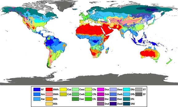
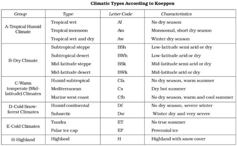
Koppen’s Climate Classification
The most widely adopted system for classifying world climates is the empirical scheme developed by Wladimir Köppen. His system is highly regarded for its scientific precision and its strong correlation between vegetation patterns and climate.
- Basis of Classification: Köppen relied on mean annual and mean monthly temperature and precipitation data, making it an empirical and quantitative classification system.
- Key Insight: He recognised that the natural vegetation of a region is the best indicator of its climate, hence linking climatology with ecology.
- Structure of Classification:
- Köppen identified five major climatic groups.
- Four were based on temperature, while one was based on precipitation.
- He employed a combination of capital and small letters to denote major groups, sub-types, and variations in climate.
Köppen’s Major Climatic Groups
- A – Tropical Climates: Hot and humid throughout the year.
- B – Dry Climates: Arid and semi-arid regions where evaporation exceeds precipitation.
- C – Temperate Climates: Moderate climates with distinct seasonal variations.
- D – Continental Climates: Severe winters and short summers, found in higher latitudes.
- E – Polar Climates: Extremely cold conditions with ice and tundra vegetation.
On the basis of distribution of seasonal rainfall the above types of humidity regions were further divided into following subdivisions:
- Y = Heavy rainfall in all seasons
- s = Scarcity of rainfall in summer season
- w = Scarcity of rainfall in winter season
- d = Scarcity of rainfall in all seasons
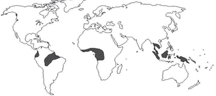
Hot and Wet Equatorial Climate
The hot and wet equatorial climate is one of the most distinctive climatic types of the world, found between 5° and 10° latitudes north and south of the equator. It dominates the lowlands of the Amazon Basin (South America), the Congo Basin (Africa), Malaysia, Indonesia, and parts of Southeast Asia. In regions slightly away from the equator, the onshore trade winds modify this climate, often blending it with monsoonal features, creating a hybrid type of equatorial-monsoon climate.
Climatic Characteristics
Temperature:
- Temperatures remain uniformly high throughout the year, with monthly averages above 18°C and an annual mean close to 26–27°C.
- The diurnal range of temperature is greater than the annual range, since daily variations are more pronounced than seasonal ones.
- Cloudiness, frequent thunderstorms, and heavy precipitation help moderate extremes of heat, ensuring sultry but not scorching conditions.
Precipitation:
- Annual rainfall exceeds 200–250 cm, making it one of the wettest regions on Earth.
- Rainfall is well distributed throughout the year, with no distinct dry season.
- Convectional rainfall dominates due to intense heating and rapid uplift of moist air. In mountainous areas, orographic rainfall is also common.
- Double rainfall maxima coincide with the equinoxes (April and October), corresponding to the vertical sun overhead.
Humidity:
- Relative Humidity is consistently high (>80%), giving the climate a muggy, oppressive character.
- Evapotranspiration is intense, and cloud cover is a near-permanent feature of the skies.
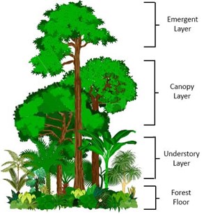
Natural Vegetation
The natural vegetation is the Tropical Evergreen Rainforest, often referred to as the “Lungs of the Planet” because of their vast contribution to the global oxygen cycle.
Characteristics:
- Dense multi-layered canopy cover, preventing sunlight from reaching the forest floor.
- Continuous evergreen foliage with no distinct seasonal shedding of leaves.
- Extraordinary biodiversity, with species richness unmatched by any other biome. Trees rarely grow in pure stands; instead, there is a mosaic of different species.
Typical Flora:
- Timber species: Mahogany, Ebony, Rosewood.
- Creepers and climbers: Lianas, epiphytes, orchids, ferns.
- Tall grasses like Lalang in open clearings.
- In some regions, a secondary forest known as Belukar emerges where the primary forest is cleared.
Soils:
- Due to rapid decomposition of leaf litter in the hot and wet conditions, the forest floor is often surprisingly bare.
- Despite heavy vegetation, soils are often leached, lateritic, and poor in nutrients, which poses a challenge for sustained agriculture.
Economic Activities
The equatorial climate, despite its abundance of resources, poses unique challenges for human habitation and economic development.
Agriculture:
- Practised through shifting cultivation, locally called by different names:
- Ladang (Malaysia), Taungya (Burma), Tamrai (Thailand), Caingin (Philippines), Humah (Java), Chena (Sri Lanka), Milpa (Central America and Africa), and Jhum (Northeast India).
- Crops include coconut, sugarcane, coffee, tea, tobacco, spices, and sago.
Commercial Crops:
- Cocoa cultivation thrives in Ghana, Côte d’Ivoire, Nigeria.
- Rubber and oil palm plantations dominate in Malaysia and Indonesia, forming the backbone of their economies.
Forestry and Resources:
- Rich in tropical hardwoods, but dense forests, lack of pure stands, and difficult transportation make large-scale lumbering challenging.
- Cobalt mining in Congo and gold mining in the Amazon Basin of Brazil and Peru are important economic activities.
Livestock Farming:
- Severely constrained by the presence of the tsetse fly, which transmits Nagana, a deadly disease affecting cattle.
Tribal Populations:
- Indigenous communities like the Pygmies of the Congo Basin and the Orang Asli of Malaysia still practise traditional ways of living such as hunting, gathering, and shifting cultivation.
Significance of the Equatorial Climate
- It supports the world’s richest biodiversity hotspots, crucial for ecological balance.
- Acts as a global carbon sink and regulator of the Earth’s climate.
- Provides economically valuable resources such as timber, rubber, oil palm, and cocoa, contributing significantly to global trade.
- Offers insight into the adaptation strategies of human societies, from shifting cultivation to modern plantation economies.
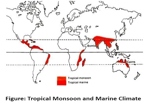
Tropical Monsoon Climate
The Tropical Monsoon Climate is one of the most distinctive and influential climatic types of the world, lying roughly between 5° and 30° latitudes north and south of the Equator. It is best developed in the Indian subcontinent, but also extends across Myanmar (Burma), Thailand, Laos, Cambodia, Vietnam, South China, and northern Australia.
The hallmark of this climate is the complete seasonal reversal of winds, driven by the shifting of pressure belts and the monsoon mechanism. During summer, the Southwest Monsoon winds bring torrential rainfall, while in winter, the Northeast Monsoon winds create dry and cool conditions.
Climatic Characteristics
Temperature:
- Mean monthly temperature remains above 18°C throughout the year.
- Summers are extremely hot, with maximum temperatures often rising above 40–45°C.
- Average summer temperatures hover around 30°C, while winter averages are around 20–25°C.
- The diurnal range is moderate, but seasonal differences are marked due to alternating wet and dry seasons.
Seasonal Cycle:
- Cool, Dry Season (October – February): Pleasant temperatures with low humidity.
- Hot, Dry Season (March – mid-June): Scorching heat, dust storms, and pre-monsoon showers in some regions.
- Rainy Season (mid-June – September): Dominated by the Southwest Monsoon, bringing heavy and concentrated rainfall.
- Rainfall: Mean annual rainfall is about 150 cm, but it shows strong temporal and spatial variations.
- Example: Cherrapunji and Mawsynram (Meghalaya, India) receive over 1000 cm, while parts of the Deccan Plateau receive less than 50 cm due to the rain-shadow effect.
Natural Vegetation
- Dominated by Tropical Deciduous (Monsoon) Forests, which shed their leaves in the dry season to conserve moisture.
- Trees are generally broad-leaved hardwoods, with Teak, Sal, Rosewood, and Shisham being common examples.
- Forests are less luxuriant compared to equatorial evergreen rainforests, with fewer species and more open canopy.
- In areas of high rainfall, semi-evergreen forests thrive, while in drier regions, vegetation grades into thorny scrub and savannah grasslands.
Economic Activities
Agriculture:
- Agriculture forms the backbone of the economy due to fertile alluvial soils and abundant rainfall.
- Wet Paddy Cultivation is the dominant agricultural activity, especially in lowlands.
- Cash Crops:
- Lowland: Sugarcane, Jute, Indigo, Cotton.
- Highland plantations: Tea, Coffee, Rubber, and Spices (India, Sri Lanka, Southeast Asia).
- Irrigation enables intensive farming, allowing multiple cropping in fertile river valleys.
- Shifting cultivation (slash-and-burn) is still practised in Northeast India (Jhum) and Southeast Asian countries.
Animal Husbandry:
- Cattle and sheep rearing are common, though productivity is often affected by seasonal feed availability.
Population Support:
- This climate supports one of the highest population densities in the world, particularly in the Indian subcontinent, due to fertile soils and agricultural prosperity.
Significance
- The Tropical Monsoon Climate has shaped the civilizations, cultures, and economies of South and Southeast Asia.
- It provides the foundation for wet-rice agriculture, sustaining millions of people.
- The seasonal monsoon winds not only influence agriculture but also regulate water resources, hydropower, and ecosystems.
- However, the climate is also marked by uncertainty of rainfall, leading to droughts, floods, and crop failures, making it one of the most vulnerable regions to climate variability and change.
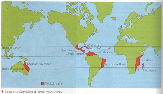
Tropical Marine Climate
The Tropical Marine Climate is found along the eastern coasts of tropical lands under the constant influence of the onshore Trade Winds throughout the year. This climate is typically experienced in regions such as Central America, the West Indies, northeastern Australia, the Philippines, parts of East Africa, Madagascar, the Guinea Coast, and eastern Brazil.
It is also known as the Trade Wind Coastal Climate and represents a transitional form between the hot, wet equatorial climate and the tropical monsoon climate.
Climatic Characteristics
Temperature:
- The region experiences high temperatures throughout the year, averaging around 25°C to 27°C.
- Diurnal and annual temperature ranges are small due to the strong maritime influence.
Rainfall:
- Rainfall is abundant, averaging between 150–250 cm annually, with no marked dry season.
- Both orographic rainfall (caused by uplands along coasts) and convectional rainfall (afternoon showers) are common.
- Rainfall tends to be heavier in the summer months when the trade winds are strongest.
Storms and Hazards:
- The region is highly prone to severe tropical cyclones, hurricanes, and typhoons, particularly during the late summer and autumn.
- These storms often bring destructive winds, torrential rainfall, and storm surges.
Natural Vegetation
- The warm and moist climate favours luxuriant vegetation.
- Typical vegetation includes:
- Tropical Rainforests in wetter parts.
- Mangroves and Coastal Vegetation along the shorelines.
- Mixed vegetation with hardwoods, coconut palms, and fruit-bearing trees.
- Unlike equatorial forests, tree species may not be as diverse, but they still support dense canopies and evergreen characteristics.
Economic Activities
Agriculture:
- Fertile coastal plains support plantation crops such as coconuts, sugarcane, bananas, pineapples, and spices.
- Cash crops like cocoa, tobacco, and coffee are also cultivated.
Fishing and Marine Economy:
- Proximity to warm seas encourages fishing, pearl diving, and other marine-based livelihoods.
Tourism:
- Many regions with tropical marine climates (Caribbean, Philippines, northeastern Australia) have developed tourism industries due to their attractive beaches and warm climate.
Significance
The Tropical Marine Climate is a crucial climatic type supporting dense populations and diverse economies. Its dependable rainfall and fertile soils sustain plantation agriculture, while its coastal position promotes trade, tourism, and fishing. However, cyclones and hurricanes pose recurring threats, making disaster management and climate adaptation essential for sustainable living in these regions.
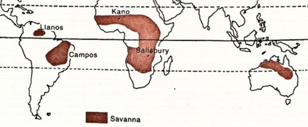
Savanna or Sudan Climate
The Savanna Climate, also known as the Sudan Climate, represents a transitional type of climate found between the evergreen equatorial forests on one side and the arid hot deserts on the other. It is typically confined between the Tropic of Cancer and the Tropic of Capricorn, hence lying completely within the tropical zone.
This climatic type is best developed in Africa (Sudan, East and Southern Africa), but also occurs in South America (Llanos of the Orinoco Basin, Campos of the Brazilian Highlands), Australia, and parts of India (Deccan Plateau and rain-shadow regions).
Climatic Characteristics
Temperature:
- The mean annual temperature is above 18°C throughout the year.
- Characterised by high day temperatures, but also marked by large diurnal ranges due to clear skies.
Rainfall:
- The Savanna climate experiences a distinct seasonal rhythm with a wet summer and a dry winter.
- Average annual rainfall ranges between 80–160 cm 【UPSC 2012】.
- Rainfall is concentrated in summer months when the overhead sun and convection currents dominate.
- Winters are dry under the influence of the trade winds, making the region prone to alternate floods and droughts.
Winds:
- Controlled by the Trade Winds which bring rains to the eastern coastal margins but lose their moisture as they move inland.
- The Harmattan Winds (locally called Doctor Winds) are dry and dusty winds blowing from the interior of Africa towards the Atlantic coast of Guinea. They provide temporary relief from hot and humid conditions by enhancing evaporation and cooling.
Natural Vegetation
The Savanna is often described as a “parkland” or “bush-veld” landscape, where tall grasses grow alongside scattered deciduous trees.
Grasslands:
- Dominated by tall grasses like elephant grass, which have deep roots and remain dormant during the dry season.
- Towards the desert margins, tall grasses gradually give way to thorny scrub vegetation.
Trees:
- Trees are typically short, deciduous, and widely spaced.
- Many species, such as Acacia, have broad trunks and water-storing adaptations to withstand long dry seasons.
- Some trees are umbrella-shaped, a unique adaptation to reduce wind resistance and evaporation.
Regional Variations:
- In Australia, scrublands are represented by Mallee, Mulga, and Spinifex grasses.
- As rainfall decreases polewards, tree height and density diminish significantly.
Wildlife and Human Activities
Wildlife:
- The Savanna is famously called the “Big Game Country” due to its extraordinary concentration of large mammals.
- Herbivores: elephants, giraffes, zebras, antelopes, wildebeests.
- Carnivores: lions, cheetahs, leopards, hyenas—forming a classic predator-prey ecosystem.
Human Occupation:
- The Savanna is home to several pastoral and tribal communities.
- Masai (Kenya and Tanzania) – renowned cattle herders.
- Hausa (Nigeria) – agriculturists and traders.
- Human activities include shifting cultivation, pastoralism, and increasingly, commercial plantations and game tourism.
Significance
The Savanna Climate occupies one of the most dynamic ecological zones of the world. It acts as a buffer between humid equatorial forests and arid deserts, supporting unique biodiversity, traditional pastoral societies, and important agricultural systems. However, the region faces serious challenges such as seasonal droughts, soil degradation, and wildlife loss due to poaching and habitat destruction.
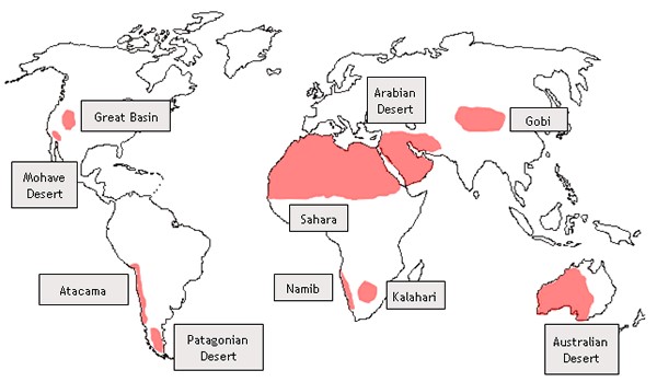
Desert Climate
Deserts are regions marked by extremely low and unreliable rainfall, intense aridity, and distinctive vegetation adapted to survive harsh conditions. These arid regions may be classified into two broad types: Hot Deserts of the subtropics (e.g., Sahara, Thar, Atacama) and Temperate or Mid-Latitude Deserts (e.g., Gobi, Patagonian Desert). Together, deserts cover nearly one-third of the Earth’s land surface and exert a profound influence on regional climate, biodiversity, and human settlement patterns.
Hot Desert Climate (Trade Wind Deserts)
The major hot deserts of the world are concentrated on the western margins of continents between 15°–30° N and S latitudes. Their formation is closely linked to the descending limbs of the Hadley Cell and the subtropical high-pressure belt.
- Examples: Sahara (North Africa), Great Australian Desert, Arabian Desert, Iranian Desert, Thar (India-Pakistan), Kalahari (Southern Africa), Namib (Southwest Africa), Mojave and Sonoran (North America), Atacama (South America).
Climatic Conditions
Temperature:
- High throughout the year, with summer averages around 30°C.
- Interior deserts record extreme heat in summers and cold winters due to lack of maritime influence.
- Diurnal temperature range is very high – days are scorching hot while nights can be freezing; frost is common in winters.
Rainfall:
- Scarce and unreliable, generally less than 25 cm annually.
- Coastal deserts (e.g., Atacama, Namib) are even drier due to cold ocean currents which suppress rainfall.
Causes of Aridity:
- Subtropical high-pressure belt (descending air inhibits rainfall).
- Offshore trade winds which are dry when they reach land.
- Cold ocean currents (e.g., Humboldt, Benguela, Canary) that increase atmospheric stability and prevent convection.
Mid-Latitude Desert Climate
These deserts occur between 30°–50° N and S latitudes, often in the interior of continents or in rain-shadow zones behind high mountain ranges.
- Examples: Gobi Desert (Mongolia & China), Patagonian Desert (Argentina), Great Basin Desert (USA), Taklamakan Desert (China).
Climatic Conditions
- Temperature: Less extreme than hot deserts, but still marked by high annual ranges due to continentality. Winters can be very cold.
- Rainfall: Generally below 25 cm annually, often brought by occasional depressions or summer convectional storms.
- Causes of Aridity:
- Continentality – far from oceans (e.g., Gobi Desert).
- Rain-shadow effect – leeward slopes of high mountains (e.g., Patagonian Desert lies behind the Andes).
Vegetation of Desert Climate
The vegetation is sparse, xerophytic (drought-resistant), and adapted to extreme aridity.
- Plants have long roots to tap groundwater.
- Leaves are either absent or modified into spines, thorns, or waxy coatings to reduce transpiration.
- Vegetation mainly consists of scrubs, succulents (e.g., cacti), thorny bushes, and scattered drought-resistant grasses.
- In desert fringes, ephemeral plants bloom briefly after rare rains, carpeting the land with flowers before withering away.
Economic Activities
Despite their hostile environment, deserts are resource-rich and support unique human adaptations.
Mining & Resources:
- Great Australian Desert – gold (Kalgoorlie, Coolgardie).
- Kalahari Desert – diamonds and copper.
- Atacama Desert – sodium nitrate, copper.
- North American Deserts – silver (Mexico), uranium (Utah), copper (Nevada).
- Sahara & Arabian Deserts – world’s largest oil reserves (Saudi Arabia, Iraq, Iran, Kuwait, Libya, Algeria).
Tribal Populations:
Bedouins (Arabia), Tuaregs (Sahara), Bushmen (Kalahari), Bindibu (Australia), Gobi Mongols (Gobi) – known for nomadic herding, camel rearing, and adaptation to desert ecology.
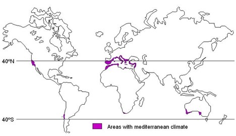
Warm Temperate Western Margin (Mediterranean) Climate
The Mediterranean climate, often described as one of the most pleasant climates of the world, is confined to the western margins of continents between 30° and 45° latitudes north and south of the Equator. Its occurrence is primarily due to the seasonal shifting of pressure and wind belts, which bring about contrasting dry summers and wet winters. This climate is best developed in the regions surrounding the Mediterranean Sea, but also occurs in central Chile, coastal California, the south-western tip of Africa, and parts of southern and south-western Australia.
Climatic Characteristics
Temperature:
- Summers are warm and dry with an average of 25°C, while winters are mild and below 10°C. The sea exerts a moderating influence, making the climate highly equable.
Rainfall:
- Annual precipitation ranges between 35–90 cm, concentrated largely in the winter months due to the influence of onshore westerlies. Summers remain dry under the dominance of offshore trade winds.
Local Winds:
- Sirocco: Hot, dry, and dusty wind from the Sahara, affecting southern Europe. Locally called Chili (Tunisia), Ghibli (Libya), Leveche (Spain), Khamsin (Egypt), and Gharbi (Adriatic & Aegean Seas).
- Mistral: A violent, cold wind descending through the Rhone Valley in France, intensified by funneling between the Alps and the Central Massif.
- Bora: A cold north-easterly wind affecting the Adriatic Sea.
- Tramontane and Gregale: Other regional cold winds shaping Mediterranean weather.
Vegetation
- The natural vegetation is sclerophyllous, consisting of shrubs and small trees adapted to summer drought.
- Distinct regional names include: Maquis (South France), Macchia (Italy), Chaparral (California), Mallee (Australia).
- Forests include pines, firs, cedars, and in some areas, the majestic Redwoods or Giant Sequoias of California.
- Bushes and thorny shrubs dominate much of the landscape.
Economic Activities
- The region is called the “World’s Orchard Lands” due to the large-scale cultivation of citrus fruits such as Sunkist oranges (California), Seville oranges (Spain), and Jaffa oranges (Israel).
- Viticulture (wine production) is a traditional Mediterranean occupation. Renowned wines include Sherry (Spain), Port (Portugal), Chianti (Italy), and Champagne, Bordeaux, Burgundy (France).
- Cultivation of nut-bearing trees like chestnuts, walnuts, almonds, and hazelnuts.
- Sheep and goat rearing in uplands is common; transhumance (seasonal migration between highland and lowland pastures) is widely practiced.
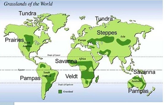
Temperate Continental (Steppe) Climate
The Steppe Climate, also known as Temperate Continental Climate, occupies the interior of continents between 40°–55° latitudes in both hemispheres. These regions lie in the belt of westerlies, but their remoteness from maritime influence produces a distinctly dry climate.
- Regional Names: Steppe (Eurasia), Pustaz (Hungary), Prairies (North America), Pampas (Argentina & Uruguay), Bush-Veld (Northern South Africa), High-Veld (Southern South Africa), Downs (Australia), Canterbury Plains (New Zealand).
Climatic Characteristics
Temperature:
- Summers are warm to hot, often exceeding 30°C.
- Winters are cold with snow, particularly severe in northern hemisphere steppes.
- In the southern hemisphere, maritime influence moderates extremes, making winters milder.
Rainfall:
- Annual rainfall varies between 25–75 cm, most of which is received in summer due to convectional sources.
- Winter precipitation occurs due to occasional depressions of the westerlies.
- Steppes near deserts are markedly dry, while those near coasts (southern hemisphere) receive more rainfall due to warm ocean currents.
Local Winds:
- In the Prairies, a hot local wind called Chinook or Snow-Eater melts snow rapidly in winter, aiding livestock grazing.
Vegetation
- Vegetation is dominated by treeless grasslands, with grasses that are short, wiry, and sparse in drier interiors, but taller and more luxuriant in wetter margins.
- Grasslands are highly nutritious and suitable for cattle ranching and sheep rearing.
- Poleward steppes gradually transform into wooded steppes, with conifers appearing in cooler zones.
Economic Activities
- Known as the “Granaries of the World”, steppe regions support extensive mechanized wheat cultivation, particularly in the Prairies and Pampas.
- Pastoral farming and ranching dominate in the drier steppes (e.g., Central Asia).
- Mixed farming, including barley, rye, oats, and maize cultivation, is common in wetter margins.
Both the Mediterranean Climate and Steppe Climate represent unique ecological and economic zones. While Mediterranean regions are synonymous with orchards, vineyards, and evergreen shrubs, the Steppe lands are the world’s major food baskets, producing surplus grain for global consumption.
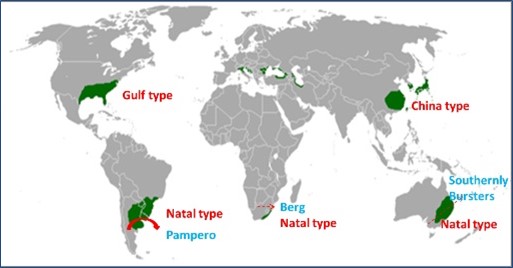
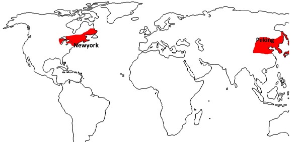
Warm Temperate Eastern Margin Climate (China Type)
The Warm Temperate Eastern Margin Climate, popularly called the China Type Climate, is a modified form of the monsoonal system. It occurs on the eastern margins of continents in the warm temperate latitudes (25°–40° N and S). The distinguishing feature of this climate is the dual control of both monsoonal and maritime influences, producing warm, moist summers and cool, dry winters.
It is best developed in Central and North China, southern Japan, Korea, the Gulf States of the USA, Eastern Australia, Southern Brazil, Paraguay, Uruguay, and Northern Argentina.
Climatic Characteristics
Temperature:
- Summers are hot and moist, while winters are cool and dry.
- Due to strong maritime influence, the annual temperature range is smaller than that of continental interiors.
Rainfall:
- Average rainfall ranges between 60–150 cm, fairly well distributed throughout the year.
- Summer rains are received from convectional thunderstorms and orographic uplift, while winter rains often result from depressions associated with westerlies.
- Late summer is marked by violent storms like typhoons in East Asia and hurricanes/tornadoes in the Gulf States of the USA.
Local Storms and Disturbances:
- Typhoons in East Asia (China, Japan, Korea).
- Hurricanes and tornadoes in the Gulf States of the USA.
- Southerly Burster (cold wind) in Australia.
- Pampero (cold dry wind) in Argentina and Uruguay.
- Berg winds in South Africa, often bringing rainfall to Natal.
Regional Subdivisions
1. China Type (East Asia):
- Found in Central & North China and South Japan.
- Distinct temperate monsoonal climate with large annual temperature range.
- Summer and winter rainfall; frequent typhoons in late summer.
2. Gulf Type (Southeastern USA):
- Modified monsoonal climate with no distinct dry season.
- Characterized by hurricanes and tornadoes.
3. Natal Type (Southern Hemisphere):
- Found in Natal (South Africa), Eastern Australia, Southern Brazil, Paraguay, Uruguay, and Northern Argentina.
- Dominated by strong maritime influence, with rainfall spread more evenly across the year.
Vegetation
- Lowlands: Dense, lush vegetation with evergreen broad-leaved forests and deciduous hardwoods (e.g., oak, camphor).
- Highlands: Presence of conifers like pines and cypresses.
- Australia: Eucalyptus forests dominate.
- Due to the absence of long dry or cold seasons, perennial plant growth is uninterrupted, leading to a rich and diverse floral cover.
Economic Activities
Agriculture:
- One of the world’s most productive agricultural regions.
- Rice cultivation dominates the lowlands of East Asia (China, Japan, Korea) due to warm, wet summers.
- Other important crops: sugarcane, cotton, tobacco, maize, tea, and jute.
- In the Gulf States (USA), agriculture includes rice, maize, and cash crops.
Plantation Crops:
- Tea in East Asia; sugarcane in the Gulf Type regions; maize and tobacco in both hemispheres.
Forestry:
- Rich timber resources: oak and camphor (China, Japan), eucalyptus (Australia), lowland deciduous forests (USA).
Animal Husbandry:
- Dairy farming is common, supported by grasslands and fodder crops.
The Warm Temperate Eastern Margin Climate (China Type) combines the rainy summers of the tropics with the cool, dry winters of the temperate regions, producing a highly favorable environment for diverse agriculture and dense population settlements.
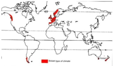
Cool Temperate Western Margin Climate (British Type / Marine West Coast Climate)
The Cool Temperate Western Margin Climate, popularly known as the British Type Climate or Marine West Coast Climate, is found between 40° and 65° latitudes in both hemispheres. Its best development is observed in North-West Europe (Britain, France, Germany, Norway, Denmark), British Columbia (USA), Southern Chile, Tasmania, and New Zealand. The term “British Type” arises because the climate of Britain is a classic example of this category.
This climate is directly influenced by the permanent westerlies, North Atlantic Drift (in Europe), and frequent frontal cyclonic activity, making it one of the most moderate and equable climates in the world.
Climatic Characteristics
Temperature:
- Characterised by mild winters and cool summers due to strong maritime influence.
- The mean annual temperature ranges between 5°C and 15°C, rarely experiencing extremes.
- Winters are short and comparatively mild because of the warming influence of oceanic currents such as the North Atlantic Drift in Europe.
Rainfall:
- Precipitation is well-distributed throughout the year, ranging between 50 cm and 250 cm annually.
- Slight maxima occur during autumn and winter, mainly due to cyclonic activity associated with the westerlies.
- Rainfall is received from frontal depressions and is often accompanied by gusty winds and storms.
Seasonal Distinction:
- Winter: Mild and short, moderated by warm ocean currents.
- Spring: Comparatively drier, transitional season.
- Summer: Long, warm, and sunny with moderate rainfall.
- Autumn: Notable for stormy weather, gusty winds, and abundant rainfall.
- This distinct four-season cycle is one of the defining features of the temperate regions.
Vegetation
The vegetation of the Marine West Coast Climate reflects the cool, moist environment:
- Deciduous forests dominate the lowlands, with trees like oak, beech, elm, birch, poplar, alder, aspen, and willow.
- At higher altitudes, coniferous trees such as firs, pines, and spruces replace deciduous vegetation.
- The region is also known for valuable hardwoods that support the timber and furniture industries.
- Grasslands and meadows thrive in areas cleared of forests, supporting dairy and livestock farming.
Economic Activities
Agriculture and Farming:
- Mixed farming is the dominant agricultural practice, combining crop cultivation and livestock rearing.
- Crops include wheat, barley, oats, potatoes, sugar beet, and vegetables.
- The region is one of the world’s leading centers of advanced dairy farming, producing butter, cheese, and milk.
Horticulture and Market Gardening:
- Particularly developed around urban centers in North-Western Europe to supply fresh fruits, vegetables, and flowers.
Sheep and Livestock Rearing:
- Sheep are reared in hilly regions such as the Scottish Highlands and New Zealand’s highlands, producing wool and mutton.
Forestry:
- Extensive exploitation of deciduous and coniferous forests provides valuable timber and pulp for the paper industry.
Fishing Industry:
- Important in countries like Britain, Norway, and Canada (British Columbia) due to the abundance of fish in the cold, nutrient-rich waters influenced by ocean currents.
The Cool Temperate Western Margin Climate or Marine West Coast Climate stands out for its equable temperatures, evenly distributed rainfall, and strong maritime influence. It is the most densely populated part of the temperate world due to its highly favorable conditions for agriculture, forestry, animal husbandry, and fishing. The climate is also historically significant, as it nurtured the growth of industrial and urban societies in Europe, laying the foundations for modern economic and social development.
Cool Temperate Eastern Margin Climate (Laurentian Type)
The Laurentian Climate is an intermediate type between the British (Marine West Coast) and the Siberian (Continental) climates. It is confined to two main regions:
- North-Eastern North America: Eastern Canada, North-East USA, and Newfoundland.
- Eastern Coastlands of Asia: Eastern Siberia, North China, Manchuria, Korea, and Northern Japan.
In the Southern Hemisphere, this type of climate is absent due to the lack of large continuous landmasses in the mid-latitudes comparable to Eurasia and North America.
Climatic Features
Temperature:
- A combination of continental and maritime influences.
- Winters are cold and dry with temperatures falling well below freezing.
- Summers are warm and moist, sometimes as hot as the tropics.
- The presence of cold Arctic currents moderates summer temperatures.
Rainfall:
- Annual rainfall ranges between 75–150 cm, fairly well distributed.
- North America: Uniform rainfall due to the influence of the Atlantic Ocean and the Great Lakes. Summers see convectional showers, winters snowfall.
- Asia: Rainfall is less uniform; resembles the monsoonal regime of India. Japan gets rainfall from the South-East Monsoon in summer and North-West Monsoon in winter.
Vegetation
- Coniferous forests north of 50°N latitude.
- Deciduous forests (oak, maple, beech, birch) south of 50°N latitude.
- Vegetation diversity reflects the transitional nature of this climate.
Economic Life
- Lumbering is the dominant occupation, given the vast forest resources.
- Agriculture is less developed due to harsh winters and a short growing season.
- Fishing is significant, particularly in the Grand Banks of Newfoundland, one of the world’s richest fishing grounds.
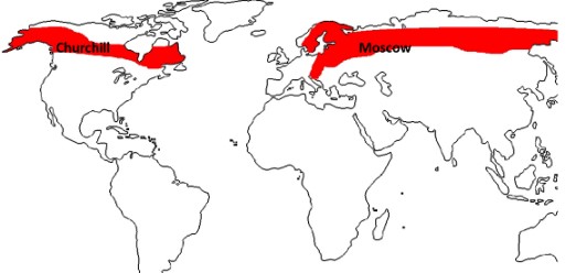
Cool Temperate Continental Climate (Siberian Type)
The Siberian Climate, also called Cool Temperate Continental Climate, is found only in the Northern Hemisphere due to the presence of massive landmasses. It extends across:
- North America: Alaska, large parts of Canada into Labrador.
- Europe and Asia: Spanning from Scandinavia to Siberia, roughly between 50°–70° N latitudes.
Climatic Features
Temperature:
- Short, warm summers (20–25°C).
- Long, bitterly cold winters (-30°C to -40°C).
- Subject to violent polar winds, such as Canadian Blizzards and Eurasian Buran.
Precipitation:
- Very low, mostly in the form of snowfall.
- Climate is essentially dry year-round.
Vegetation
- Taiga or Boreal Forests dominate the region, with trees adapted to harsh conditions.
- Coniferous adaptations: conical shapes, needle-like leaves, thick bark to resist frost.
- Podzolized soils limit fertility.
- In tundra-like margins, only mosses, lichens, dwarf willows, and hardy grasses grow.
Economic Life
- Lumbering is the backbone, providing vast quantities of softwood (conifers) used in paper, pulp, and construction.
- Logs transported downstream on rivers to industrial centers.
- Agriculture is limited, confined to hardy crops like rye, barley, oats, and potatoes during the short growing season.
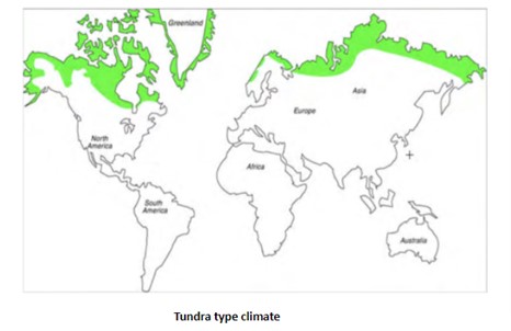
Arctic or Polar Climate (Tundra Type)
The Polar or Tundra Climate is found north of the Arctic Circle in the Northern Hemisphere and across Antarctica in the Southern Hemisphere. It represents the harshest climate zone on Earth, marked by extreme cold, minimal precipitation, and very short summers.
Climatic Features
Temperature:
- Winters are long and extremely cold, often plunging below -37°C.
- Summers are brief and cool, with temperatures rarely exceeding 10°C.
Precipitation:
- Very low, usually less than 25 cm annually.
- Mostly in the form of snow or freezing rain.
- Slight summer maxima occur, sometimes as sleet or rain.
Vegetation
- Tundra vegetation is highly stunted due to permafrost.
- Dominated by mosses, lichens, dwarf shrubs, reindeer moss, and hardy grasses.
- No tall trees, as roots cannot penetrate frozen subsoil.
- During the short summer, snowmelt creates a burst of growth called “Arctic Prairies”, with small flowering plants blooming briefly.
Economic Life
- Human habitation is sparse, limited to indigenous tribes like the Eskimos (Inuit), Lapps (Sami), and Samoyeds, who practice fishing, hunting, and reindeer herding.
- Housing includes igloos in winter and skin tents in summer.
- Mineral resources (oil, natural gas, and coal in Arctic Russia, Canada, and Alaska) are increasingly exploited.