
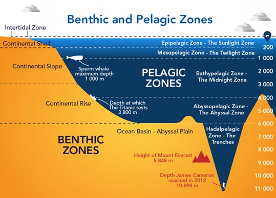
Vertical Zones of the Ocean
1. Epipelagic Zone (Sunlight Zone)
- Depth: Surface to ~200 m.
- Characteristics: Receives maximum sunlight penetration, allowing photosynthesis. This makes it the most biologically productive zone.
- Life: Plankton, tuna, dolphins, and whales thrive here. Upwelling currents bring nutrients to support rich ecosystems.
2. Mesopelagic Zone (Twilight Zone)
- Depth: 200–1,000 m.
- Characteristics: Light diminishes sharply; photosynthesis ceases. Temperatures drop steadily.
- Life: Organisms adapt with bioluminescence (light-producing ability) to survive in semi-darkness. Squid, lanternfish, and deep-diving predators are common.
3. Bathypelagic Zone (Midnight Zone)
- Depth: 1,000–4,000 m.
- Characteristics: Absolute darkness, near-freezing temperatures, and crushing pressures dominate.
- Geological Features: Includes abyssal plains and trenches formed by tectonic forces.
- Life: Species like giant squids, anglerfish, and other highly specialised creatures survive here.
4. Abyssopelagic Zone (Abyssal Zone)
- Depth: 4,000–6,000 m.
- Characteristics: Pitch-dark, extremely cold, and nutrient-poor environment.
- Geological Features: Dominated by abyssal plains, ridges, and slow accumulation of sediments.
- Life: Sparse but includes tube worms, crustaceans, and extremophile bacteria.
5. Hadalpelagic Zone (Hadal Zone)
- Depth: Beyond 6,000 m, in oceanic trenches.
- Characteristics: The deepest, most extreme environment on Earth.
- Geological Features: Includes subduction zones, deep trenches, and hydrothermal vents.
- Life: Unique extremophiles adapted to immense pressure and near-freezing conditions. These organisms survive on detritus falling from upper layers or on chemosynthesis near hydrothermal vents.
Significance of Ocean Relief and Zonation
- Climate Regulation: Ocean basins influence circulation of currents, which transport heat and moisture across the globe.
- Biodiversity Hotspots: From the coral-rich neritic zones to the mysterious hadal depths, each zone sustains unique ecosystems.
- Navigation and Economy: Continental shelves aid shipping and fishing, while trenches and ridges impact submarine navigation and undersea cables.
- Resource Distribution: Oceans store enormous mineral, energy, and biological resources vital for the global economy.
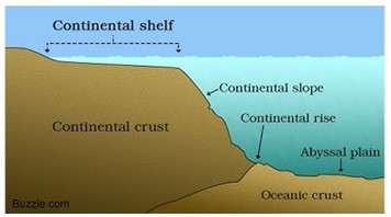
Major Ocean Relief Features
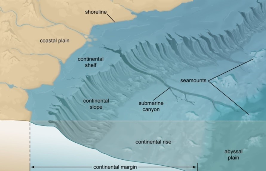
The ocean floor, though hidden beneath vast stretches of water, is far from flat. It exhibits a variety of relief features shaped by tectonic activity, volcanism, erosion, and deposition. Broadly, the oceanic relief can be divided into four major features: continental shelf, continental slope, continental rise, and abyssal plain (deep-sea plain). Together, these features not only define the structure of ocean basins but also influence marine ecosystems, navigation, fisheries, and resource distribution.
1. Continental Shelf
- The continental shelf is the gently sloping seaward extension of a continent, with a gradient of 1° or less. It usually terminates at a sharp decline known as the shelf break.
- Extent: They occupy 7.5% of the total ocean area, forming shallow seas and gulfs.
- Examples: The Sunda Shelf (Southeast Asia), Grand Banks near Newfoundland, and the shelf between Australia and New Guinea are well-known examples.
Formation of Continental Shelves
Continental shelves are formed due to:
- Submergence of continental margins after sea-level rise.
- Sedimentary deposits brought down by rivers and glaciers.
- Marine processes like wave erosion and deposition.
Types of Shelves
- Glaciated Shelf: e.g., Greenland shelf.
- Coral Reef Shelf: e.g., Queensland (Australia).
- River-formed Shelf: e.g., Nile Delta shelf.
- Shelf with dendritic valleys: e.g., Hudson River mouth.
- Shelf along young mountain belts: e.g., Hawaiian Islands.
Width and Depth
- Average width: 70–80 km.
- Depth varies from 30 m (shallowest) to 600 m (deepest).
- Siberian Shelf in the Arctic is the largest in the world, stretching nearly 1,500 km into the sea.
- Shelves are absent or very narrow along convergent boundaries (e.g., Chilean coast).
Importance of Continental Shelves
- Petroleum & Natural Gas: Nearly 20% of global oil and gas reserves are located here.
- Minerals: Source of placer deposits, phosphorites, and polymetallic nodules.
- Fisheries: Continental shelves are the richest fishing grounds due to nutrient upwelling (e.g., Grand Banks of Newfoundland, North Sea).
- Economic Use: Shallow waters facilitate navigation, port development, and offshore industries.
2. Continental Slope
- The continental slope connects the continental shelf with the deep ocean basins.
- Gradient: 2°–5°, steeper than the shelf.
- Depth: Extends from about 200 m to 3,000 m.
- It marks the true edge of continents and often contains submarine canyons and trenches carved by turbidity currents.
- The slope eventually merges into the continental rise.
3. Continental Rise
- The continental rise is the zone where the slope loses its steepness and merges into the abyssal plain.
- Gradient: 0.5°–1°, making it gentler than the slope.
- It consists of thick accumulations of sediments transported by rivers, glaciers, and ocean currents.
- Often referred to as the transition zone between the continental slope and the deep-sea floor.
4. Deep-Sea Plain (Abyssal Plain)
- The abyssal plains are the flattest, smoothest, and most extensive regions of the ocean floor, covering nearly 40% of the ocean basins.
- Depth: Between 3,000–6,000 m.
- Formed by terrigenous (land-derived) and shallow-water sediments that bury underlying irregularities.
- Despite appearing flat, abyssal plains may host features like seamounts, guyots, abyssal hills, and deep trenches.
Significance of Major Ocean Relief Features
- Climate Regulation: Continental shelves and slopes influence ocean currents, which regulate global climate.
- Biodiversity Hotspots: Shallow shelves sustain coral reefs, fisheries, and marine ecosystems.
- Resource Potential: Rich in hydrocarbons, minerals, and fisheries, making them economically vital.
- Navigation and Ports: Shallow shelves and continental margins allow safe harbour construction and shipping routes.
- Scientific Importance: Provide insights into plate tectonics, marine geology, and past climatic conditions.
Minor Ocean Relief Features
Beyond the four major ocean relief features (continental shelf, slope, rise, and abyssal plain), the ocean floor also contains several minor relief features that add to its complexity. These features—formed due to tectonic activity, volcanism, erosion, and deposition—are critical for understanding plate tectonics, navigation, fisheries, and marine biodiversity.
The minor relief features include ridges, abyssal hills, trenches, submarine canyons, island arcs, atolls, banks, shoals, and reefs.
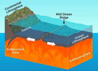
1. Oceanic Deeps or Trenches
- Trenches are narrow, elongated depressions on the ocean floor, usually 3–5 km deeper than surrounding seabed.
- Origin: They are of tectonic origin, formed along convergent plate boundaries during ocean-ocean or ocean-continent subduction.
- Association: Linked with active volcanoes and strong earthquakes (e.g., Japan, Philippines, Andes).
- Location: Found along the fringes of deep-sea plains, near continental slopes and island arcs.
- Global Distribution: Majority occur in the Pacific Ocean, followed by the Atlantic and Indian Oceans. In the Pacific, trenches almost form a continuous ring (Ring of Fire).
- Example: The Mariana Trench (near Guam, Pacific Ocean) is the deepest part of the world’s oceans, plunging over 11 km.
2. Mid-Oceanic Ridges (Submarine Ridges)
- These are continuous underwater mountain ranges formed along divergent plate boundaries.
- Structure: A mid-oceanic ridge is composed of two mountain chains separated by a rift valley (depression).
- Extent: Stretching for about 75,000 km, they form the largest mountain system on Earth.
- Elevation: Peaks rise up to 2,500 m, with some emerging above sea level (e.g., Iceland).
- Examples:
- Mid-Atlantic Ridge (between Europe/Africa and the Americas).
- East Pacific Rise.
- Significance: Sites of seafloor spreading, volcanism, and hydrothermal vents, supporting unique ecosystems.
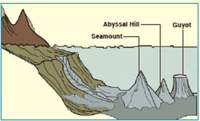
3. Abyssal Hills (Seamounts and Guyots)
Seamounts:
- Volcanic mountains rising from the seafloor with pointed summits but not reaching the surface.
- Height: 3,000–4,500 m.
- Example: Emperor Seamount chain, extension of Hawaiian Islands.
Guyots:
- Flat-topped seamounts formed due to erosion of peaks by waves and currents before subsiding below sea level.
- Common in the Pacific Ocean.
Importance:
- Many are associated with coral reefs, biodiversity hotspots, and mineral deposits.
4. Submarine Canyons
- Submarine canyons are deep, steep-sided valleys cutting across the continental shelf, slope, and rise, often extending to abyssal plains.
- Formation: Created mainly by erosion of sediments brought by rivers and turbidity currents.
- Scale: They are often larger and deeper than canyons on land.
Types of Submarine Canyons
- Shelf-edge canyons: Begin at the edge of shelves, e.g., Oceanographer Canyon (New England).
- River-mouth canyons: Extend from river mouths, e.g., Indus Canyon.
- Dendritic canyons: Branch-like patterns cut into shelves/slopes, e.g., Southern California canyons.
- Examples: Hudson Canyon (USA), Bering Sea canyons (largest in the world).
- Significance: Act as conduits for sediment transport and enhance marine productivity.
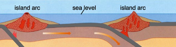
5. Island Arcs
- Curved chains of volcanic islands formed along subduction zones (ocean-ocean convergence) or hotspots.
- Examples:
- Japan Islands.
- Philippines.
- Aleutian Islands (Alaska).
- Significance: Mark regions of intense seismic and volcanic activity and are densely populated due to fertile soils.
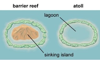
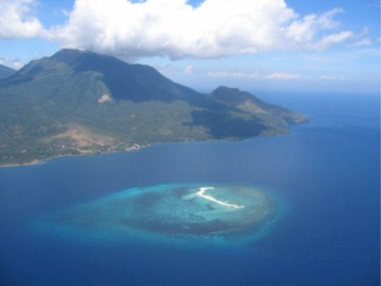
6. Atolls and Coral Reefs
- Atolls: Ring-shaped low islands of coral reefs surrounding a central lagoon. Found mainly in tropical oceans.
- Lagoon may contain sea water, brackish water, or even highly saline water.
- Example: Lakshadweep Islands (India), Marshall Islands (Pacific).
- Atolls: Ring-shaped low islands of coral reefs surrounding a central lagoon. Found mainly in tropical oceans.
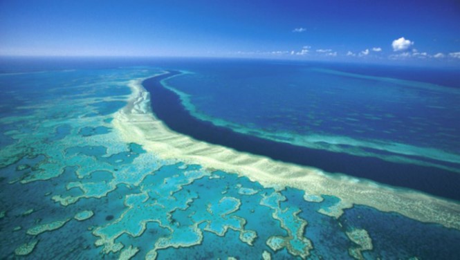
- Coral Reefs: Organic deposits formed by living or dead corals.
- The Great Barrier Reef (Australia) is the largest coral reef system in the world.
- Reefs are hazardous to navigation but are biodiversity hotspots.
- Coral Reefs: Organic deposits formed by living or dead corals.
7. Banks, Shoals, and Reefs
Banks
- Flat-topped elevations on continental margins formed by erosion and deposition.
- Depth: Shallow but navigable.
- Richest fishing grounds due to nutrient upwelling.
- Examples: Dogger Bank (North Sea), Grand Bank (Newfoundland).
Shoals
- Detached elevations with very shallow water, often protruding above the surface.
- Dangerous for navigation due to hidden underwater hazards.
Reefs
- Rocky or coral ridges projecting near or above the sea surface.
- Found abundantly in the Pacific Ocean.
- Significant for marine biodiversity, coastal protection, and tourism, but risky for ships.
Significance of Minor Ocean Relief Features
- Marine Biodiversity: Reefs, atolls, and seamounts are biodiversity hotspots.
- Economic Resources: Trenches, ridges, and banks are rich in minerals, hydrocarbons, and fisheries.
- Navigation: Features like shoals and reefs pose hazards, requiring accurate marine charts.
- Plate Tectonics: Trenches, ridges, and island arcs provide evidence of seafloor spreading and subduction.
- Climate & Ecology: Submarine canyons and upwelling zones enhance nutrient cycling and global fisheries.
Ocean Movements – Ocean Currents and Tides
The oceans, which cover more than 71% of the Earth’s surface, are not static water bodies. They are constantly in motion, driven by a variety of forces operating both at the surface and in the deep layers. These movements are collectively classified as waves, tides, and currents, each of which plays a critical role in shaping global climate, marine ecosystems, and human activities such as navigation and fisheries.
Waves and Tidal Waves
- Waves are formed primarily due to friction between wind and the surface water layer. Their height and energy depend on the velocity, duration, and fetch (distance of uninterrupted wind flow).
- Ordinary waves die out quickly upon reaching the shore or shallow waters, but special categories of waves such as tsunamis, storm surges, and tidal waves have much larger wavelengths, travel long distances, and exert significant influence on coastal regions.
- Tsunamis result from undersea earthquakes, volcanic eruptions, or landslides. Storm surges are associated with cyclones, while tides are long-period waves generated by the gravitational pull of the Moon and Sun.
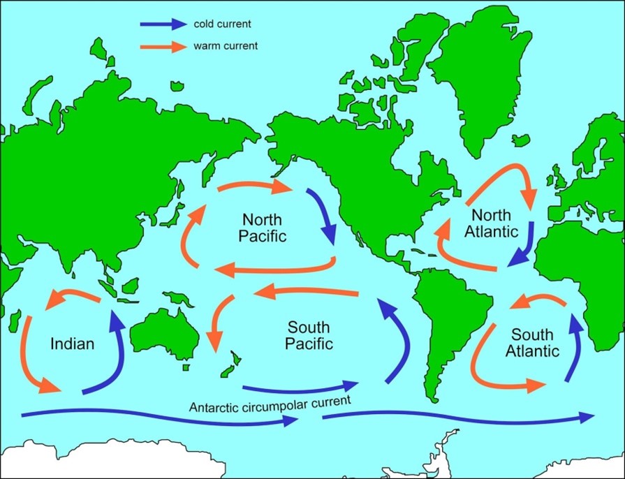
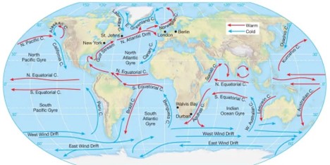
Ocean Currents
Among oceanic movements, currents are the most significant because they involve the large-scale, continuous, and directed movement of water masses. Ocean currents are like rivers within the sea, transporting not only water but also heat, nutrients, and marine organisms, thereby exerting a profound impact on global climate, weather patterns, and economies.
Definition: Ocean currents may be described as a regular mass of water flowing along a defined path and direction under the influence of various forces. They may be surface currents or deep water currents, and warm or cold currents depending on their origin and flow.
Forces Influencing Ocean Currents
Ocean currents are controlled by a combination of primary forces (which initiate motion) and secondary forces (which modify flow).
1. Primary Forces
- Heating by Solar Energy: Differential insolation creates temperature contrasts, leading to variations in density. Near the equator, heating causes water to expand and form a gentle slope (up to 8 cm higher than mid-latitudes). Gravity then pulls this water downslope, setting up currents.
- Wind (Atmospheric Circulation): The frictional drag of prevailing winds initiates large-scale horizontal currents. Winds also decide the magnitude and direction of currents, which further follow the pattern of atmospheric circulation. For example, the monsoon winds cause the seasonal reversal of currents in the Indian Ocean, a phenomenon unique in the world.
- Gravity: Acts to equalize differences in sea level, aiding water flow from higher to lower levels.
- Coriolis Force: Deflects currents to the right in the Northern Hemisphere and to the left in the Southern Hemisphere, giving rise to circular ocean gyres.
2. Secondary Forces
- Temperature and Salinity Differences: Variations in temperature and salinity create density gradients that produce both horizontal and vertical currents.
- Colder and saltier water is denser and tends to sink, while warmer and fresher water
- This process drives the thermohaline circulation, also called the “global conveyor belt,” which regulates Earth’s long-term climate.
- Temperature and Salinity Differences: Variations in temperature and salinity create density gradients that produce both horizontal and vertical currents.
Indian Ocean Currents
Unlike other oceans, the Indian Ocean currents are unique because of the monsoonal reversal of winds, which causes seasonal changes in circulation in the north Indian Ocean.
Winter Circulation (Northeast Monsoon)
- Both North Equatorial Current and South Equatorial Current flow westwards.
- A Counter-Equatorial Current develops eastwards.
- The northeast monsoon winds drive anticlockwise circulation in both the Bay of Bengal and Arabian Sea.
Summer Circulation (Southwest Monsoon)
- The North Equatorial Current disappears, and strong southwest monsoon winds push water eastwards.
- Circulation becomes clockwise in the northern Indian Ocean.
- This reversal is critical for the Indian Monsoon system.
Southern Indian Ocean Currents
- The South Equatorial Current flows westwards, splitting into:
- Agulhas Current (Warm): east of Madagascar, later merging with West Wind Drift.
- Mozambique Current (Warm): between Mozambique and Madagascar.
- At Madagascar’s southern tip, they unite into the Agulhas Current, later merging with the West Wind Drift.
- A branch of the West Wind Drift flows northward along western Australia as the West Australian Current (Cold).
- The South Equatorial Current flows westwards, splitting into:
Type of Current | Ocean Current | Key Features |
Warm Currents | East Madagascar Current | – Southward-flowing along the eastern coast of Madagascar.– Merges with the Mozambique Current to form the Agulhas Current. |
Mozambique Current | – Flows southward through the Mozambique Channel (between Madagascar and mainland Africa).– Joins the East Madagascar Current to form the Agulhas Current. | |
Agulhas Current | – Fast-flowing southwestward current along the east coast of South Africa.– Formed by the confluence of the Mozambique and East Madagascar Currents. | |
Cold Currents | West Australian Current | – Slow northward flow along the western coast of Australia.– Shows lower marine productivity than other eastern boundary currents (e.g., Humboldt, Benguela) due to weak upwelling.– Interaction with the warm Leeuwin Current further suppresses nutrient upwelling. |
South Indian Current | – Eastward current across the southern Indian Ocean.– Connects the Agulhas Current with the West Australian Current, forming part of the Indian Ocean gyre. | |
Somali Current | – Unique seasonal current that reverses direction and temperature.– Flows northward as a cold current during the southwest monsoon (June–September).– Flows southward as a warm current during the northeast monsoon (November–February). |
Effects of Ocean Currents
1. Desert Formation
- Cold currents along west coasts (e.g., Benguela, Peru) produce arid climates by suppressing convection, aiding in desert formation like the Atacama, Namib, and Kalahari.
2. Rainfall Distribution
- Warm currents bring rainfall to coastal and interior regions (e.g., North Atlantic Drift → British climate).
- Cold currents often cause fog and drizzle instead of rainfall.
3. Tropical Cyclones
- Warm currents create pools of warm water that fuel tropical cyclones. Example: Bay of Bengal cyclones intensify due to warm currents.
4. Fisheries
- Mixing zones of warm and cold currents are the richest fishing grounds (e.g., Grand Banks, Japan coast).
- Nutrient upwelling sustains plankton growth, the base of marine food chains.
5. Climate Moderation
- Warm currents moderate the harsh winters of high latitudes (e.g., NW Europe).
- Cold currents bring cooling to tropical coasts (e.g., Canary Current → Iberian Peninsula).
6. Navigation
- Ocean currents affect shipping routes.
- Example: Ships from Mexico to the Philippines use the North Equatorial Current (east to west), while the return route uses the Counter-Equatorial Current (west to east).
- Historically, sailing ships relied heavily on these currents, though modern vessels are less dependent.
Ocean currents act as global conveyors of heat, nutrients, and energy, linking the oceans, atmosphere, and continents into a single integrated system. While they moderate climates, sustain fisheries, and aid navigation, they also create arid deserts, trigger cyclones, and generate foggy hazards.
Tides: Mechanics, Types, and Geographical Significance
Tides are the periodic rise and fall of sea level driven primarily by the Moon’s gravity, secondarily by the Sun’s gravity, and modulated by the Earth–Moon–Sun geometry and Earth’s rotation. Their behavior varies widely by coastline shape, basin depth, and shelf width, making tidal analysis both spatially and temporally complex.
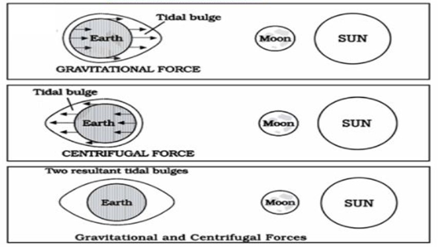
Origin of Tides
- The moon’s gravitational pull is the primary factor, while the sun’s gravitational force plays a secondary role.
- The centrifugal force generated due to Earth’s rotation acts opposite to gravitational pull, balancing the forces and generating tidal bulges.
Why Two Tidal Bulges?
- On the side of Earth nearest to the moon, the moon’s gravity exceeds centrifugal force, pulling water towards it → first tidal bulge.
- On the opposite side, the moon’s gravitational pull is weaker, and centrifugal force dominates, pushing water away from the moon → second tidal bulge.
Thus, Earth experiences two high tides and two low tides in roughly 24 hours.
Factors Influencing Tides
The nature, height, and intensity of tides are not uniform across the globe. They are shaped by a combination of astronomical, geographical, and local factors.
1. Relative Position of the Moon and Earth
- Since the moon is the nearest celestial body to Earth, its gravitational pull is the dominant force behind tides.
- When the moon is closer to Earth, its gravitational effect increases, creating higher tidal ranges.
2. Position of the Sun
- Although the sun is much farther away, its immense size also contributes to tidal forces.
- When the sun and moon align in a straight line with Earth, their gravitational pull combines, producing exceptionally high tides (spring tides).
3. Unequal Distribution of Land and Water
- Continents obstruct the free movement of tidal waves. As a result, the oceanic tides are unevenly distributed, and their characteristics vary depending on the geography of coastlines.
4. Irregular Configuration of Ocean Basins
- The shape of bays, gulfs, and estuaries can greatly amplify tidal effects.
- Funnel-shaped coasts, such as the Bay of Fundy in Canada, experience the world’s highest tidal range (15–16 metres) due to the funnelling effect.
5. Local Factors
- Coastal topography, depth of the water, and interaction with ocean currents influence the timing and height of tides.
- Shallow seas amplify tidal ranges, while deeper seas often reduce them.
Types of Tides
Tides can be classified based on their frequency, celestial alignment, and distances between celestial bodies.
Based on Frequency
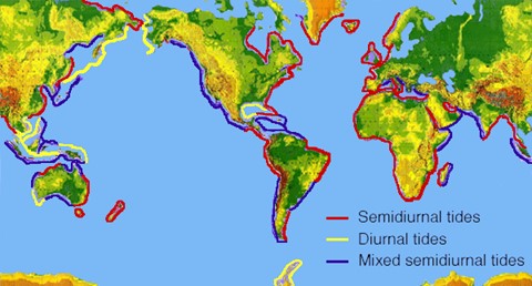
1. Semi-Diurnal Tides
- The most common tidal type worldwide.
- Characterized by two high tides and two low tides each day, almost equal in height.
- Occurs at an interval of 12 hours and 25 minutes, corresponding to the moon’s eastward motion.
- Example: The port of Southampton, where complex interactions between the North Sea and the English Channel produce multiple tidal highs and lows daily.
2. Diurnal Tides
- Characterized by only one high tide and one low tide per day.
- This phenomenon is caused by continental interference in tidal forces, which disrupts the regular semi-diurnal pattern.
- Example: The Gulf of Mexico, where diurnal tides dominate.
3. Mixed Tides
- Resemble semi-diurnal tides but with unequal successive highs and lows.
- This mixed pattern is particularly common along tectonically active coastlines.
- Example: The Pacific coast of North America and many Pacific islands.
Based on Sun-Moon-Earth Alignment
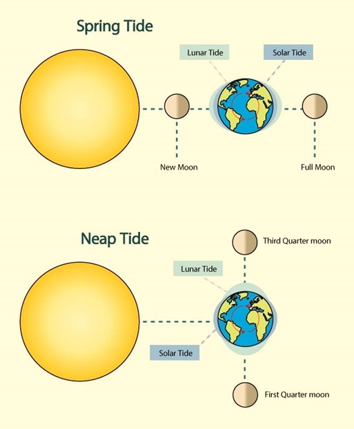
1. Spring Tides
- Occur when the Earth, moon, and sun are aligned in a straight line (syzygy).
- Gravitational forces of the moon and sun reinforce each other, leading to the highest tidal ranges.
- These tides occur twice a month, during the new moon and full moon phases.
2. Neap Tides
- Occur when the sun and moon are positioned at right angles to Earth.
- The gravitational pulls partially counteract each other, producing the lowest tidal ranges.
- These tides also occur twice a month, roughly midway between spring tides.
Based on Earth-Moon-Sun Distances
- Perigean Tides: When the moon is at perigee (closest to Earth), tidal ranges are unusually high.
- Apogean Tides: When the moon is at apogee (farthest from Earth), tidal ranges are weaker.
- Perihelion Tides: Around 3rd January, when Earth is closest to the sun (perihelion), tides are stronger.
- Aphelion Tides: Around 4th July, when Earth is farthest from the sun (aphelion), tidal ranges are weaker.
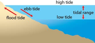
Ebb and Flood Tides
- Ebb Tide: The period when the water level falls between high tide and low tide.
- Flood Tide: The period when the water level rises between low tide and high tide.
- It is important to note that tidal intervals are not exactly 12 hours but about 12 hours 25 minutes, due to the moon’s eastward movement.
Importance of Tides
Tides, which result from the gravitational pull of the moon and the sun on the earth, play a vital role in shaping human activities and the natural environment. Since the relative positions of the earth, moon, and sun are accurately predictable, tidal patterns can be forecast well in advance. This makes tides highly significant for navigation, fishing, coastal economies, and even power generation.
Navigation and Harbours
One of the most important contributions of tides is in facilitating navigation. Many harbours, particularly those located near river mouths and estuaries, often have shallow sandbars at their entrances, which make ship movement difficult. High tides raise the water level close to the shores, enabling vessels to enter or leave ports more easily. This is particularly useful for large ships and ocean-going vessels.
Several important ports of the world owe their prominence to tidal advantages. For instance, the Port of London and Haldia Port in Kolkata are classic examples of tidal ports that became successful due to the tidal nature of the Thames and Hooghly rivers, respectively. In addition, tides help in making certain rivers navigable for ocean-going ships, thereby enhancing inland–sea connectivity.
Economic and Environmental Significance
Beyond navigation, tides contribute to economic and ecological processes:
- Tidal Energy: The immense force of moving seawater is harnessed to generate tidal power, which is a renewable and eco-friendly source of electricity. Countries such as Canada, France, Russia, and China have developed large-scale tidal power projects. In India, a 3 MW tidal power project was built at Durgaduani in the Sundarbans, West Bengal.
- Tidal Currents and Estuarine Health: The rise and fall of tides create tidal currents. During high tides, seawater flows into estuaries, while low tides reverse the direction. This movement helps in the circulation of nutrients and oxygen, prevents silting of sediments, and removes pollutants from river estuaries. Such processes are essential for maintaining the health of aquatic ecosystems.
- Fishing Activities: Tides also have a direct impact on fishing. High tides bring large shoals of fish closer to the shore, making it easier for fishermen to catch them. Fishing communities in coastal regions traditionally plan their activities in accordance with tidal timings.
Characteristics of Tides
The behaviour and intensity of tides are influenced by several geographical and physical factors.
- On the surface of the earth, horizontal tidal forces (such as barriers and funnel effects) often play a greater role than vertical forces (the direct gravitational pull of the moon and sun) in shaping tidal bulges.
- Continental Shelves: When tidal waves strike wide continental shelves, they rise higher due to the barrier effect. Conversely, when tidal waves hit mid-oceanic islands, their heights are significantly reduced due to the absence of barriers.
- Bays and Estuaries: The shape of bays and estuaries along a coastline magnifies tidal intensity. Funnel-shaped bays act like amplifiers of tides. For example, the Bay of Fundy in Nova Scotia, Canada, experiences the highest tidal range in the world, reaching up to 15–16 metres.
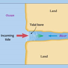
- Tidal Currents: When tides are channelled into bays, gulfs, or estuaries, the water moves inward and outward in rhythmic cycles, creating what is known as tidal currents. In some cases, this results in a tidal bore, which is one of the most dramatic tidal phenomena.
Tidal Bore
A tidal bore occurs when a strong tide enters a narrow and shallow estuary of a river. As the tidal wave moves upstream, it collides with the flowing river water and encounters resistance from the friction of the riverbed, creating a steep, vertical wall of water rushing inland. This wall-like crest of water produces a thunderous sound, which is why it is termed a “bore”.
- Occurrence: Tidal bores are associated with flood tides and almost never occur during ebb tides or neap tides. They generally take place in regions with a large tidal range (over 6 metres) between high and low water levels.
- Global Examples: Some of the most famous tidal bores are seen in the Qiantang River in China, which is considered the most powerful, and the Amazon River in Brazil, where the wide but shallow mouth and presence of low-lying islands create strong tidal surges.
- India: In India, tidal bores are commonly observed in the Hooghly River, significantly impacting navigation and local fishing practices.
Impact of Tidal Bores
While tides are generally stable and predictable, tidal bores are less predictable and can be hazardous. Their impacts include:
- Navigation Hazards: Powerful tidal bores can severely disrupt shipping and navigation in estuarine zones. Strong bores are capable of capsizing boats and ships of considerable size, posing risks to human life and trade.
- Ecological Effects: The violent movement of water during a tidal bore can disrupt estuarine ecosystems. Aquatic animals caught in the front edge of the wave may be killed or buried under sediments. This creates opportunities for carnivores and scavengers, which often follow behind tidal bores in search of stranded prey.
- Fishing Communities: Tidal bores interfere with fishing activities in estuaries and gulfs, leading to economic challenges for local fishing communities.
Thus, while tidal bores are spectacular natural phenomena, they are also dangerous and ecologically disruptive, requiring careful observation and management in regions prone to their occurrence.
Tides embody the intricate relationship between celestial mechanics and ocean dynamics. They are not only a physical expression of the Earth–Moon–Sun gravitational interaction, but also a powerful force shaping human livelihood, coastal ecosystems, global fisheries, energy production, and even military strategy.