
Interior of Earth, Plate Tectonics and Related Phenomenon
Earth’s Internal Structure
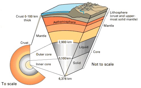
The Earth’s internal structure is composed of three main concentric layers: the Crust, Mantle, and Core. Each layer differs in thickness, composition, density, and physical properties, making Earth a dynamic planet where processes such as plate tectonics, volcanism, and geomagnetic activity originate.
1. Crust – The Outermost Solid Layer
The crust is the Earth’s outermost, rigid shell, forming less than 1% of Earth’s total volume but playing a vital role in sustaining life and shaping the surface. It is brittle, thin, and divided into continental crust and oceanic crust. Together with the uppermost mantle, it forms the lithosphere.
Continental Crust
- Average Thickness: ~30–40 km (up to 70 km under mountain ranges like the Himalayas).
- Density: ~2.7 g/cm³.
- Composition: Dominated by granitic rocks, rich in silica (Si) and aluminium (Al), collectively called SIAL.
- Conrad Discontinuity: The boundary between the upper and lower continental crust.
- Characteristic: Older, thicker, and less dense than oceanic crust, hence “floating higher” on the mantle.
Oceanic Crust
- Average Thickness: ~5–10 km.
- Density: ~3.0 g/cm³ (denser than continental crust).
- Composition: Mainly basaltic rocks, rich in silica (Si), magnesium (Mg), and iron (Fe), collectively known as SIMA.
- Formation: Created at mid-ocean ridges by rapid cooling of magma, leading to younger and denser rocks.
- Characteristic: Constantly recycled into the mantle at subduction zones, unlike the older continental crust.
Comparison: Oceanic vs Continental Crust
- Composition: Oceanic crust has mafic minerals (e.g., olivine and pyroxene), while continental crust has felsic minerals (e.g., quartz and feldspar).
- Density Difference: Mafic minerals are compact and heavy → higher density; felsic minerals are lighter → lower density.
- Formation Process: Oceanic crust forms rapidly at ridges; continental crust evolves slowly with lighter materials.
Element | Oceanic Crust (% by Mass) | Continental Crust (% by Mass) |
Oxygen (O) | 43.00% | 46.60% |
Silicon (Si) | 21.00% | 27.70% |
Aluminum (Al) | 8.00% | 8.10% |
Iron (Fe) | 7.00% | 5.00% |
Magnesium (Mg) | 7.00% | 2.10% |
Calcium (Ca) | 11.00% | 3.60% |
Sodium (Na) | 3.50% | 2.80% |
Potassium (K) | — | 2.60% |
Other Elements | 1.50% | 1.50% |
2. Mantle – The Layer of Convection and Dynamics
The mantle extends from the Mohorovičić Discontinuity (Moho) to about 2,900 km depth, making up ~84% of Earth’s total volume. It consists of ultramafic silicate rocks rich in iron (Fe) and magnesium (Mg).
Asthenosphere (Upper Mantle: ~100–200 km depth)
- Semi-fluid, ductile, and viscous in nature.
- Acts as the source of magma for volcanic eruptions.
- Plays a key role in plate tectonics, as lithospheric plates float and move over it.
- Hotter and more deformable compared to the rigid lithosphere.
Lithosphere
- Composed of the crust + uppermost rigid mantle.
- Divided into tectonic plates, which drift over the asthenosphere.
- Thickness: ~10–200 km (thicker under continents, thinner beneath oceans).
Lower Mantle (Extending to ~2,900 km)
- Located below the asthenosphere.
- Remains solid under high pressure and temperature, despite partial plasticity.
- Heat transfer occurs mainly by convection currents, driving plate movements.
- Repetti Discontinuity separates the upper and lower mantle.
3. Core – The Metallic Heart of Earth
The core begins at a depth of ~2,900 km and extends to the Earth’s center (~6,371 km). It is composed primarily of iron (Fe) and nickel (Ni), hence called the NiFe layer.
Outer Core
- State: Liquid, due to extreme heat (~4,000–5,000°C).
- Role: The motion of molten iron generates Earth’s geomagnetic field through the geodynamo effect.
- Boundary: Separated from the mantle by the Gutenberg Discontinuity.
Inner Core
- State: Solid, despite very high temperatures (~5,000–6,000°C), because immense pressure prevents melting.
- Boundary: Separated from the outer core by the Lehmann Discontinuity.
- Interesting Fact: The inner core may be slowly solidifying over time as Earth cools.
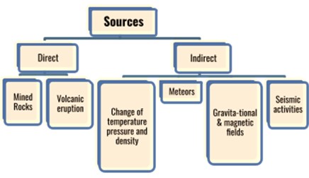
Sources of Knowledge about Earth’s Interior
Since direct observation is limited, geologists rely on both direct and indirect methods:
a)Direct Sources
- Surface rocks exposed by erosion.
- Volcanic eruptions that bring mantle material to the surface.
- Deep drilling projects (e.g., Kola Superdeep Borehole, ~12 km deep).
- Mining activities reaching several kilometers underground.
b) Indirect Sources
- Seismic waves (P-waves and S-waves) revealing differences in density and state of matter.
- Gravitational studies, showing uneven distribution of mass inside Earth.
- Magnetic field studies, indicating the presence of a metallic, fluid outer core.
- Meteors, assumed to have a composition similar to Earth’s interior, provide valuable clues.
The crust, mantle, and core together form a complex system that drives Earth’s dynamic processes. From the brittle crust supporting life to the convecting mantle driving plate tectonics, and the metallic core sustaining Earth’s magnetic shield, each layer plays a crucial role in making Earth unique and habitable. For UPSC, understanding this structure is essential not only for geography and geology but also for linking concepts like earthquakes, volcanism, climate, and life-supporting conditions on our planet.
Isostasy:
Isostasy is the concept of gravitational equilibrium between the Earth’s crust and the denser mantle beneath it. It implies that the Earth’s crust behaves like a floating body, similar to an iceberg floating on water, where elevation is determined by density and thickness. This principle helps explain why continents stand higher than oceans and why mountain systems are supported by deep roots.
Key Models of Isostasy
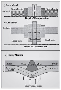
1. Pratt’s Model (Variable Density Concept)
- Proposed by John Henry Pratt (1855).
- Assumes that the crust has uniform thickness below sea level but variable density.
- Less dense crustal blocks (granite-rich continents) rise higher, while denser blocks (basalt-rich oceans) sink lower.
- Example: Continental crust (lighter, granitic) floats higher than oceanic crust (denser, basaltic).
2. Airy’s Model (Variable Thickness Concept)
- Proposed by George Airy (1855).
- Assumes the crust has uniform density but variable thickness.
- Mountains are compensated by deep crustal roots penetrating the mantle, while plains have shallow roots.
- Example: The Himalayas possess deep roots beneath them to balance their great elevation.
3. Vening Meinesz Model (Flexural Isostasy)
- Introduced by Dutch geophysicist Felix Vening Meinesz (20th century).
- Views the lithosphere as a flexible plate instead of rigid blocks.
- Large loads (mountains, ice sheets, volcanoes) cause the lithosphere to bend and adjust regionally.
- Example: The bending of the lithosphere beneath the massive Himalayan range or under ice sheets in Greenland.
Significance in Geography: Isostasy explains mountain building, subsidence of ocean basins, post-glacial rebound, and helps in understanding tectonic processes.
Rocks: Types, Features, and Geological Processes
Rocks are naturally occurring solid aggregates made up of one or more minerals or mineraloids, forming the fundamental building blocks of the Earth’s crust. Unlike minerals, which have a definite chemical composition and crystalline structure, rocks exhibit wide variations in colour, hardness, texture, mineral composition, and density.
The study of rocks is known as Petrology, a sub-discipline of geology that helps in understanding the origin, structure, and composition of the Earth’s crust. Rocks not only record the geological history of our planet but also act as reservoirs of natural resources such as metallic ores, coal, petroleum, groundwater, and building materials.
On the basis of their origin, rocks are broadly divided into three major types:
- Igneous Rocks – Formed through the cooling and solidification of molten magma or lava.
- Sedimentary Rocks – Created by the deposition, compaction, and cementation of sediments.
- Metamorphic Rocks – Produced when existing rocks undergo transformation under high heat, pressure, or chemical processes.
These types are interconnected through the Rock Cycle, a continuous process where one rock type can change into another depending on geological conditions.
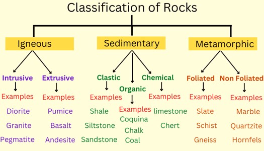
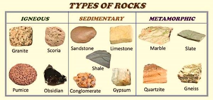
1. Igneous Rocks – The Primary Rocks
Igneous rocks are regarded as the original or primary rocks since they form directly from magma (molten material beneath the Earth’s surface) or lava (molten material extruded onto the surface). The cooling rate plays a decisive role in determining crystal size:
- Intrusive/Plutonic Rocks: Slow cooling beneath the surface produces large, coarse crystals.
- Extrusive/Volcanic Rocks: Rapid cooling on the surface results in fine-grained or glassy textures.
Types of Magma and Associated Rocks
Type of Magma | Silica Content | Characteristics | Colour & Density | Examples of Rocks |
Felsic Magma | ~70% silica | Highly viscous, rich in silica, potassium, and sodium; low in iron & magnesium | Light-coloured, less dense | Granite (intrusive), Rhyolite (extrusive) |
Intermediate Magma | 55–65% silica | Moderate viscosity, balanced composition of silica and ferromagnesian minerals | Medium colour (grey/greenish) | Diorite (intrusive), Andesite (extrusive) |
Mafic Magma | 45–55% silica | Low viscosity, rich in iron and magnesium; flows easily | Dark-coloured, denser than felsic | Gabbro (intrusive), Basalt (extrusive, oceanic crust) |
Ultramafic Magma | <45% silica | Very low viscosity, extremely rich in magnesium and iron, very high melting point | Dark green to black, very dense | Peridotite, Komatiite |
Classification
A. Intrusive (Plutonic) Igneous Rocks – Coarse-grained, formed inside the crust.
- Granite – Rich in quartz and feldspar; widely used in architecture and construction.
- Gabbro – Dense, dark-coloured, makes up much of the oceanic crust.
- Pegmatite – Exceptionally large crystals; source of rare minerals like tourmaline.
B. Extrusive (Volcanic) Igneous Rocks – Fine-grained, formed on the surface.
- Basalt – The most abundant volcanic rock; covers ocean floors.
- Andesite – Found in volcanic arcs near subduction zones.
- Rhyolite – High silica, light-coloured, associated with explosive eruptions.
Key Features
- Hard and compact due to crystalline texture.
- Non-fossiliferous since they originate from molten material.
- Impermeable and resistant to water infiltration.
- Durable and resistant to chemical weathering.
Chemical Composition-Based Types
- Acidic Rocks: Rich in silica, light-coloured (e.g., granite).
- Basic Rocks: Rich in Mg and Fe, darker in colour (e.g., basalt).
- Felsic Rocks: Dominated by feldspar and quartz.
- Mafic Rocks: Iron- and magnesium-rich, darker and denser.
- Ultramafic Rocks: Extremely rich in Mg and Fe (e.g., peridotite).
2. Sedimentary Rocks – Records of Earth’s Past
Sedimentary rocks are secondary rocks formed by the deposition, compaction, and cementation of sediments. These sediments may originate from mechanical weathering, biological remains, or chemical precipitation. Though they form only a small portion of Earth’s volume, they cover nearly three-fourths of the Earth’s surface, making them crucial in understanding Earth’s history.
Type | Rock | Description |
A. Mechanically Formed (Clastic Rocks)Composed of weathered rock fragments | Sandstone | Sand-sized particles; often reservoir of oil and gas |
Conglomerate | Rounded pebbles bound together | |
Shale | Fine-grained; derived from clay and mud | |
B. Organically Formed RocksDerived from biological remains | Limestone | From shells and corals; key raw material in cement industry |
Chalk | From calcareous marine organisms | |
Coal | From compacted plant remains; vital fossil fuel | |
C. Chemically Formed RocksCreated by mineral precipitation | Rock Salt | From evaporation of saline water |
Chert/Flint | Silica-based, fine-grained |
Key Features
- Stratification: Distinct layers or strata.
- Fossil-rich: Preserve remains of plants and animals, vital for paleontology.
- Porous and permeable: Important aquifers and hydrocarbon reservoirs.
- Relatively soft: Easier to erode compared to igneous and metamorphic rocks.
3. Metamorphic Rocks – Rocks of Transformation
Metamorphic rocks are formed when pre-existing igneous or sedimentary rocks undergo transformation under extreme heat, pressure, or chemically active fluids. This process, called metamorphism, alters their mineral structure and texture, making them denser, harder, and more compact.
Type | Rock | Description |
A. Foliated Metamorphic RocksExhibit banding or layering | Slate | Derived from shale; fine-grained; used in roofing |
Schist | Rich in mica; strongly foliated | |
Gneiss | Alternating light and dark mineral bands | |
B. Non-Foliated Metamorphic RocksNo banding; uniform texture | Marble | From limestone; calcite-rich; widely used in art and construction |
Quartzite | From sandstone; very hard and durable |
Key Features
- Crystalline and compact
- Harder than parent rocks.
- Varied colours due to mineral content.
- Rarely fossiliferous due to extreme metamorphism.
Metamorphic Processes
- Dynamic Metamorphism: Due to pressure along fault zones.
- Thermal Metamorphism: Caused by high temperatures near magma.
- Contact Metamorphism: Localised changes from igneous intrusions.
- Regional Metamorphism: Large-scale changes during mountain building (orogeny).
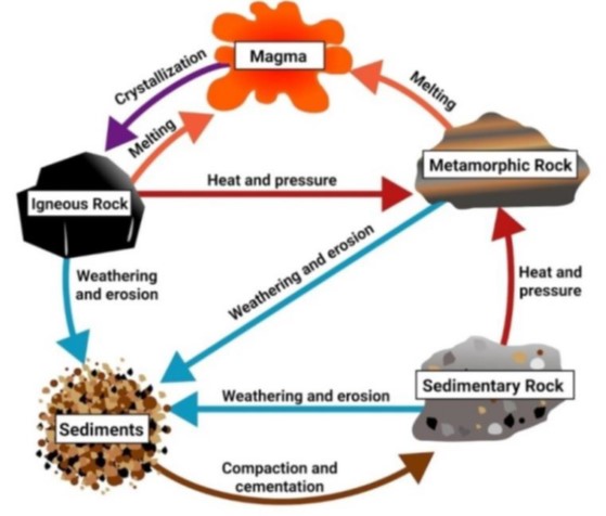
The Rock Cycle
The rock cycle is a dynamic and continuous geological process that explains how the three major rock types—igneous, sedimentary, and metamorphic—are interconnected and transformed through Earth’s internal and external forces. It highlights the cyclical nature of rock formation, destruction, and reformation, driven by processes such as heat, pressure, erosion, and volcanism.
Key Stages of the Rock Cycle
1. Weathering and Erosion
- Rocks exposed at the Earth’s surface are broken down by physical, chemical, and biological agents.
- The resulting sediments (sand, clay, gravel, silt) are transported by wind, rivers, glaciers, or waves.
2. Sedimentation and Lithification
- Sediments accumulate in layers in basins such as riverbeds, lakes, or oceans.
- Over time, compaction and cementation (lithification) transform these loose particles into sedimentary rocks like sandstone, shale, or limestone.
3. Metamorphism
- When sedimentary or igneous rocks are subjected to intense heat, pressure, or chemically active fluids, they undergo mineralogical and structural changes.
- This process produces metamorphic rocks such as gneiss, marble, or schist.
4. Melting
- Metamorphic or igneous rocks may be driven deep into the Earth’s mantle, where they melt due to high temperature and pressure, forming magma.
5. Cooling and Solidification
- Magma that reaches the surface as lava or remains beneath the crust cools and solidifies, crystallising into igneous rocks like granite (intrusive) or basalt (extrusive).
Oceans and Continents Distribution
Continental Drift Theory
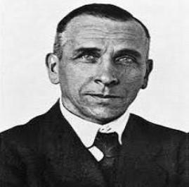
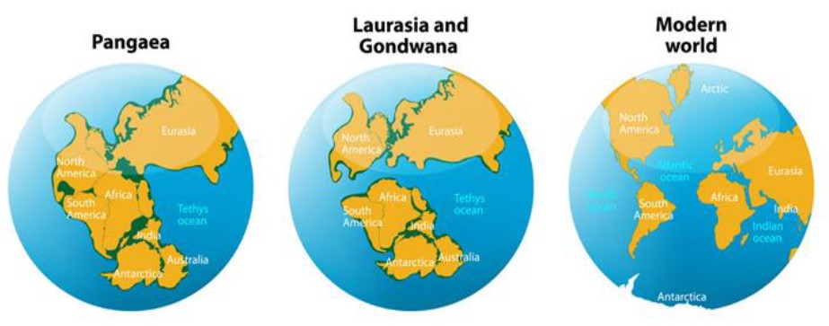
In 1912, German meteorologist Alfred Wegener proposed the Continental Drift Theory, which revolutionized geological thought. He suggested that the Earth’s continents were once joined together as a single massive landmass called Pangaea, surrounded by a global ocean known as Panthalassa. Over geological time, this supercontinent began to break apart and drift to their present positions.
Key Propositions of Wegener’s Continental Drift Theory
1. The Supercontinent Cycle
- According to Wegener, the Earth’s continents were once joined together in a single vast supercontinent called Pangaea (Greek for “all Earth”). This colossal landmass existed about 200–250 million years ago (Mesozoic Era).
- Pangaea was surrounded by a global ocean known as Panthalassa, which covered the rest of the Earth’s surface.
- Around 200 million years ago, Pangaea began to break apart due to internal geological forces, giving rise to two major landmasses:
- Laurasia in the Northern Hemisphere, comprising present-day North America, Europe, and Asia (excluding India).
- Gondwanaland in the Southern Hemisphere, comprising South America, Africa, Antarctica, Australia, Madagascar, and the Indian subcontinent.
- Over millions of years, these two super landmasses continued to fragment and drift into their current positions, forming the modern distribution of continents.
This idea was revolutionary because it implied that continental positions are not permanent but are part of a dynamic Earth system.
2. Continental Movement
- Wegener strongly emphasized that continents are not static; instead, they have been slowly drifting across the Earth’s surface over geological time.
- He proposed that continents move horizontally, ploughing through the denser oceanic crust, much like icebergs floating in the sea.
- This drift explained why certain continents (e.g., Africa and South America) fit together like a jigsaw puzzle and why similar rocks, fossils, and geological features are found on distant continents.
- Though Wegener did not have the correct mechanism (later explained by plate tectonics and mantle convection currents), his core idea of continental mobility laid the foundation for modern geology.
Evidence Supporting Continental Drift
1. The Jigsaw Fit of Continents
- The coastlines of South America and Africa fit together remarkably well, resembling a jigsaw puzzle.
- This strongly suggests that these continents were once joined.
2. Geological Similarities
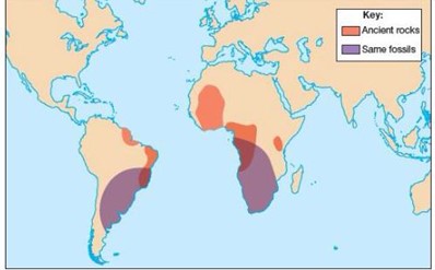
- Rocks of the Same Age: A 2-billion-year-old rock formation in Brazil shows striking similarity with rocks in western Africa, implying they were once part of the same crustal block.
- Tillite Evidence: Tillites (sedimentary rocks from glacial deposits) found in India, Africa, Madagascar, and Antarctica suggest a common glacial history under Gondwanaland.
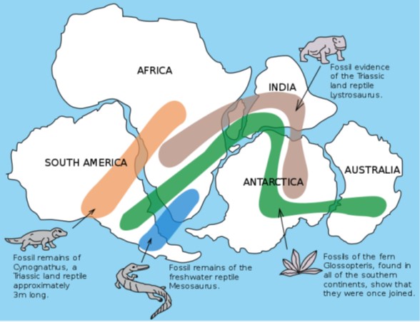
3. Fossil Distribution
- `merica, Africa, and Australia.
4. Placer Deposits
- The Ghanaian coast has placer deposits of gold, despite the absence of local gold-bearing rocks.
- This suggests geological continuity with Brazilian plateaus, where similar gold-bearing veins exist.
Drawbacks of Continental Drift Theory
1. Too general with silly and sometimes illogical evidences.
- Buoyancy and Gravity act in opposite directions.
- The Earth would have stopped rotation if then tidal force exerted by sun and moon is strong enough to rift the continents.
2. It doesn’t explain why drift initiated only in Mesozoic era and not before.
- The continental drift theory was unable to provide then strong reason for continent movement.
- This issue was eliminated by the later studies.
Post-Drift Theories and Mechanisms
While Alfred Wegener’s Continental Drift Theory (1912) was revolutionary, it lacked a convincing mechanism for the movement of continents. Later, in the mid-20th century, several scientists refined and strengthened his ideas by proposing scientifically sound mechanisms. Two major post-drift explanations are the Convection Current Theory and the Seafloor Spreading Hypothesis, which together laid the foundation for the Plate Tectonics Theory.
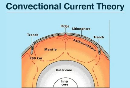
1. Convection Current Theory (Arthur Holmes, 1930s)

In the 1930s, British geologist Arthur Holmes proposed that convection currents in the Earth’s mantle acted as the driving force behind the drifting of continents. His theory gave a realistic physical explanation that was missing in Wegener’s hypothesis.
Mechanism
- Heat Generation: Radioactive isotopes (e.g., uranium, thorium, potassium) within the Earth’s mantle undergo radioactive decay, releasing enormous amounts of heat.
- Mantle Convection: This heat reduces the density of mantle material, causing it to rise towards the lithosphere. Upon cooling, it becomes denser and sinks back toward the deeper mantle, creating a continuous cyclical flow pattern.
- Plate Movement: These convection currents act like a conveyor belt, dragging overlying tectonic plates (continents and oceanic crust) along with them.
Significance
- Holmes’ theory provided the first scientifically credible mechanism for continental drift.
- It explained mountain building, volcanic activity, and earthquakes as surface expressions of mantle convection.
- This concept later became a cornerstone in the development of Plate Tectonics (1960s).
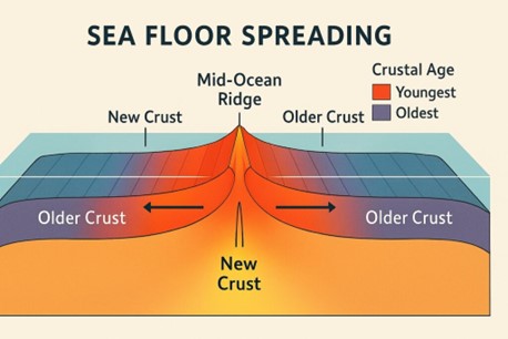
2. Seafloor Spreading Hypothesis (Harry Hess, 1960s)
In the early 1960s, American geologist Harry Hess proposed the theory of Seafloor Spreading, which provided direct evidence for continental drift and explained the creation and destruction of oceanic crust.
Hess’s Hypothesis
- New Crust Formation: Magma from the mantle rises through fractures at mid-ocean ridges (divergent boundaries), solidifying into new basaltic crust.
- Expansion of the Ocean Floor: As new crust is added, older crust is pushed outward, causing the ocean floor to spread like a conveyor belt.
- Destruction of Oceanic Crust: At deep-sea trenches (convergent boundaries), older oceanic crust subducts into the mantle and is recycled. This balances crust creation with destruction, ensuring Earth’s surface does not expand.
Driving Mechanism
- The heat generated by radioactive decay powers mantle convection, which in turn drives:
- Rising currents at mid-ocean ridges (divergence).
- Sinking currents at subduction zones (convergence).
- The heat generated by radioactive decay powers mantle convection, which in turn drives:
Evidence Supporting Seafloor Spreading
- Volcanic Activity: Continuous eruptions along mid-ocean ridges form new basaltic crust.
- Age of Oceanic Rocks: Oceanic crust is youngest at ridges and becomes progressively older away from them.
- Magnetic Striping: Symmetrical patterns of magnetic polarity reversals are preserved in rocks on either side of mid-ocean ridges, proving periodic crust formation.
- Thin Sediment Cover: Ocean floors have very thin sediment layers compared to continents, indicating that the oceanic crust is geologically young and constantly renewed.
- Seismic Activity:
- Shallow earthquakes occur along mid-ocean ridges.
- Deep-focus earthquakes occur near trenches, confirming subduction of old crust.
Key Geologic Features of Seafloor Spreading
- Mid-Ocean Ridges: Underwater mountain chains where new crust is created (e.g., Mid-Atlantic Ridge).
- Deep-Sea Trenches: Long, narrow depressions where old crust subducts (e.g., Mariana Trench).
- Magnetic Striping: Symmetrical “zebra-like” bands of normal and reversed polarity across ridges, providing one of the strongest proofs of seafloor spreading.
Plate Tectonics
The Plate Tectonics Theory, developed during the 1960s, is considered one of the most revolutionary ideas in the Earth sciences. It integrates earlier concepts of Continental Drift (Wegener) and Seafloor Spreading (Hess) into a unified framework. According to this theory, the Earth’s lithosphere (outer rigid shell, comprising the crust and upper mantle) is divided into several large and rigid slabs of solid rock, known as tectonic plates. These plates float and move over the semi-fluid asthenosphere beneath, driven by thermal and mechanical forces.
This theory explains the origin of mountain ranges, earthquakes, volcanoes, oceanic trenches, rift valleys, and continental drift, making it the grand unifying theory of geology.
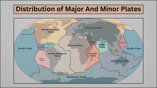
Major and Minor Plates
The Earth’s lithosphere is divided into about seven major plates and more than a dozen minor plates.
Major Plates:
- Pacific Plate
- North American Plate
- South American Plate
- Eurasian Plate
- African Plate
- Indo-Australian Plate (sometimes considered as separate Indian and Australian plates)
- Antarctic Plate
Minor Plates:
- Nazca Plate (off the west coast of South America)
- Cocos Plate (near Central America)
- Arabian Plate
- Philippine Plate
- Caribbean Plate
- Scotia Plate, etc.
These plates interact with each other along their boundaries, giving rise to various geological processes.
Mechanisms of Plate Movement
The movement of tectonic plates is caused by forces originating within the Earth’s mantle:
1. Heat Generation
- The radioactive decay of elements (uranium, thorium, potassium) in the mantle generates enormous heat.
- This heat drives mantle convection currents, which act like conveyor belts, dragging plates along.
2. Ridge Push
- At divergent boundaries (like mid-ocean ridges), newly formed crust exerts a pushing force on older plates, causing them to move outward.
3. Slab Pull
- At convergent boundaries, the denser, subducting oceanic plate sinks into the mantle due to gravity, pulling the rest of the plate with it.
- This is considered the most significant driving force for plate tectonics.
Together, these mechanisms explain why continents drift, oceans expand or shrink, and mountains rise.
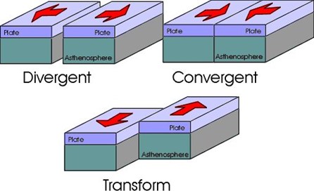
Types of Plate Boundaries
1. Divergent Boundaries (Constructive)
- Plates move away from each other, creating new crust.
- Found at mid-ocean ridges where magma rises to form new basaltic crust.
- Example: Mid-Atlantic Ridge (separating North American and Eurasian Plates).
2. Convergent Boundaries (Destructive)
- Plates move towards each other, resulting in subduction or collision.
- Types:
- Oceanic–Oceanic Convergence: One oceanic plate subducts beneath another, forming island arcs (e.g., Aleutian Islands).
- Oceanic–Continental Convergence: The denser oceanic plate subducts beneath the continental plate, creating fold mountains and volcanic arcs (e.g., Andes Mountains).
- Continental–Continental Convergence: Both buoyant continental plates collide, causing fold mountain building (e.g., Himalayas).
3. Transform Boundaries (Conservative)
- Plates slide past each other horizontally, without creating or destroying crust.
- Example: San Andreas Fault (California, USA).
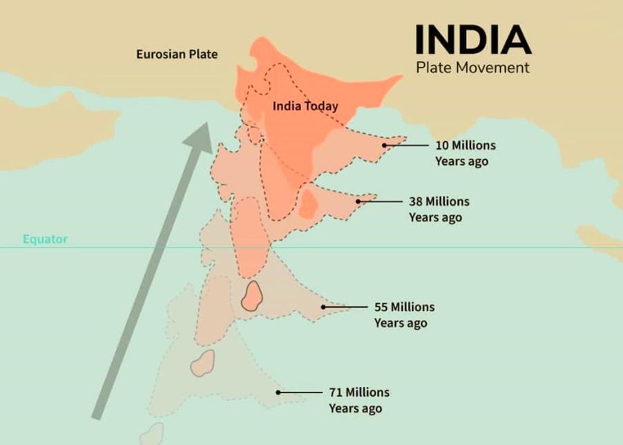
Movement of the Indian Plate
The Indian Plate has a unique geological history:
- Ancient Position: About 225 million years ago, India was an island near the southern hemisphere, lying close to Australia and Antarctica, separated from Asia by the Tethys Sea.
- Northward Journey: Around 200 million years ago, India drifted northwards after the breakup of Gondwanaland.
- Collision with Asia: Around 40–50 million years ago, India collided with the Eurasian Plate, leading to the rapid uplift of the Himalayas and the Tibetan Plateau.
- Present Movement: The Indian Plate continues to move northwards at about 5 cm per year, causing frequent earthquakes and crustal deformations in the Himalayas.
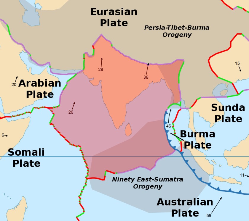
Major Plate Boundaries of the Indian Plate
- Northern Boundary: Convergent with the Eurasian Plate, forming the Himalayas and the Tibetan Plateau.
- Western Boundary: Convergent with the Arabian Plate, associated with seismic activity in the Makran coast and Baluchistan region.
- Eastern Boundary: Convergent with the Burmese Plate, giving rise to the Arakan Yoma ranges and frequent earthquakes in Northeast India.
- Southern Boundary: Divergent with the Australian Plate, marked by spreading along the Indian Ocean Ridge.
Types of Volcanoes and Their Lava
Volcanoes are classified based on their lava composition, structure, eruption style, and geological setting. Each type plays a distinct role in shaping Earth’s surface and influencing the environment.
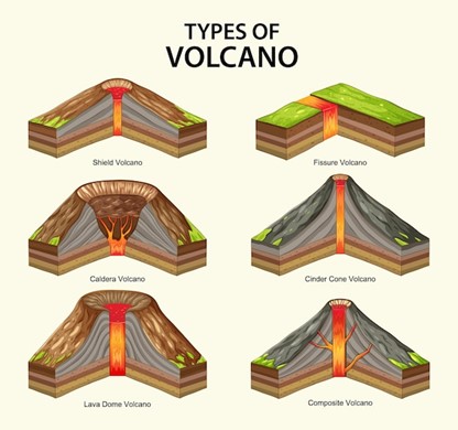
1. Shield Volcanoes
- Lava Type: Predominantly mafic (basaltic), low in silica, very fluid.
- Shape: Broad, gently sloping domes, resembling a warrior’s shield, formed by successive flows of runny lava.
- Eruption Style: Effusive, non-explosive eruptions, where lava spreads over vast distances.
- Significance: Create some of the largest volcanoes on Earth; eruptions are less violent but cover extensive areas.
- Examples:
- Mauna Loa (Hawaii, USA): Largest active volcano in the world.
- Kilauea (Hawaii, USA): Noted for continuous eruptions.
- Skjaldbreiður (Iceland): A classic shield volcano in the North Atlantic.
2. Composite Volcanoes (Stratovolcanoes)
- Lava Type: Intermediate to felsic, high viscosity, and gas-rich.
- Shape: Steep, conical profile, built from alternating layers of lava flows, volcanic ash, and pyroclastic deposits.
- Eruption Style: Highly explosive, producing pyroclastic flows, volcanic bombs, and towering ash clouds.
- Significance: Among the most hazardous volcanoes due to violent eruptions and potential for widespread destruction.
- Examples:
- Mount Fuji (Japan): Iconic stratovolcano with symmetrical cone.
- Mount St. Helens (USA): 1980 eruption reshaped the entire summit.
- Mount Vesuvius (Italy): Destroyed Pompeii in AD 79.
- Mount Etna (Italy): One of the most active volcanoes in Europe.
3. Cinder Cone Volcanoes
- Lava Type: Usually basaltic, but may vary.
- Shape: Small, steep-sided cones, built from loose fragments of ash, cinders, and volcanic bombs.
- Eruption Style: Short-lived, moderately explosive eruptions that eject lava fragments which accumulate around the vent.
- Significance: Typically smaller in size, often form on the flanks of larger volcanoes.
- Examples:
- Parícutin (Mexico): Emerged suddenly in 1943 from a cornfield.
- Sunset Crater (Arizona, USA): Well-preserved cinder cone.
- Lava Butte (Oregon, USA): A young cone within the Cascade Range.
4. Lava Domes (Volcanic Domes)
- Lava Type: Felsic, highly viscous, silica-rich.
- Shape: Mound-like, dome-shaped structures formed by slow extrusion of lava near vents.
- Eruption Style: Effusive but may become dangerous when domes collapse, triggering pyroclastic flows.
- Significance: Often associated with stratovolcanoes, marking late stages of eruption cycles.
- Examples:
- Novarupta (Alaska, USA): Site of the largest eruption of the 20th century.
- Mount St. Helens Lava Dome (USA): Rebuilt after the 1980 eruption.
- Puy de Dôme (France): A classic dome in the Auvergne region.
5. Calderas
- Formation: Result from the collapse of a volcanic summit or magma chamber after massive eruptions.
- Shape: Large circular depressions, often several kilometers wide, sometimes filled with lakes.
- Eruption Style: Associated with supervolcanic eruptions, among the most catastrophic events in Earth’s history.
- Significance: Can alter global climate due to enormous ash and gas emissions.
- Examples:
- Yellowstone Caldera (USA): Located over a mantle plume, source of past super-eruptions.
- Krakatoa (Indonesia): 1883 eruption triggered tsunamis and global climatic effects.
- Santorini (Greece): Linked with the ancient Minoan eruption.
6. Flood Basalt Provinces (Large Igneous Provinces)
- Lava Type: Extremely fluid basaltic lava with low viscosity.
- Shape: Vast, flat-lying plateaus of basalt, covering thousands of square kilometers.
- Eruption Style: Gigantic, prolonged effusive eruptions, releasing massive amounts of gases.
- Significance: Linked with mass extinction events due to climate-altering gas emissions.
- Examples:
- Deccan Traps (India): Formed ~66 million years ago, associated with dinosaur extinction.
- Siberian Traps (Russia): Correlated with the Permian-Triassic extinction.
- Columbia River Basalts (USA): Major basalt province in North America.
7. Mid-Ocean Ridge Volcanoes
- Lava Type: Mafic (basaltic).
- Shape: Long, linear submarine ridges along divergent plate boundaries.
- Eruption Style: Continuous, submarine effusive eruptions that form new oceanic crust.
- Significance: Fundamental to seafloor spreading and plate tectonics.
- Examples:
- Mid-Atlantic Ridge (Atlantic Ocean).
- East Pacific Rise (Pacific Ocean).
- Reykjanes Ridge (near Iceland).
Volcanoes Based on Periodicity of Eruption
1. Active Volcanoes: Currently erupting or have erupted in recent history.
- Examples: Mount Stromboli (Italy – “Lighthouse of the Mediterranean”), Mount St. Helens (USA), Mount Vesuvius (Italy).
2. Dormant Volcanoes: Not erupted recently but may erupt again in the future.
- Example: Mount Kilimanjaro (Tanzania).
3. Extinct Volcanoes: No eruptions in geological history; often filled with lakes.
- Example: Edinburgh’s Arthur’s Seat (UK).
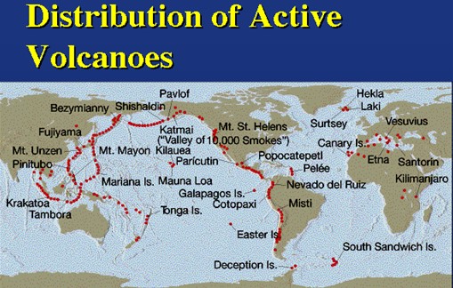
Distribution of Volcanoes
The global distribution of volcanoes closely coincides with seismic activity zones, as both are directly linked to the movement of tectonic plates. Volcanic activity is most prominent along divergent and convergent plate boundaries, though it also occurs at isolated hotspots.
1. Volcanic Zones and Plate Boundaries
- Divergent Boundaries: Found along mid-oceanic ridges, where tectonic plates move apart, allowing magma to rise and form new crust.
- Example: Mid-Atlantic Ridge.
- Divergent Boundaries: Found along mid-oceanic ridges, where tectonic plates move apart, allowing magma to rise and form new crust.
- Convergent Boundaries: Common along subduction zones, where one plate is forced beneath another, generating intense volcanism.
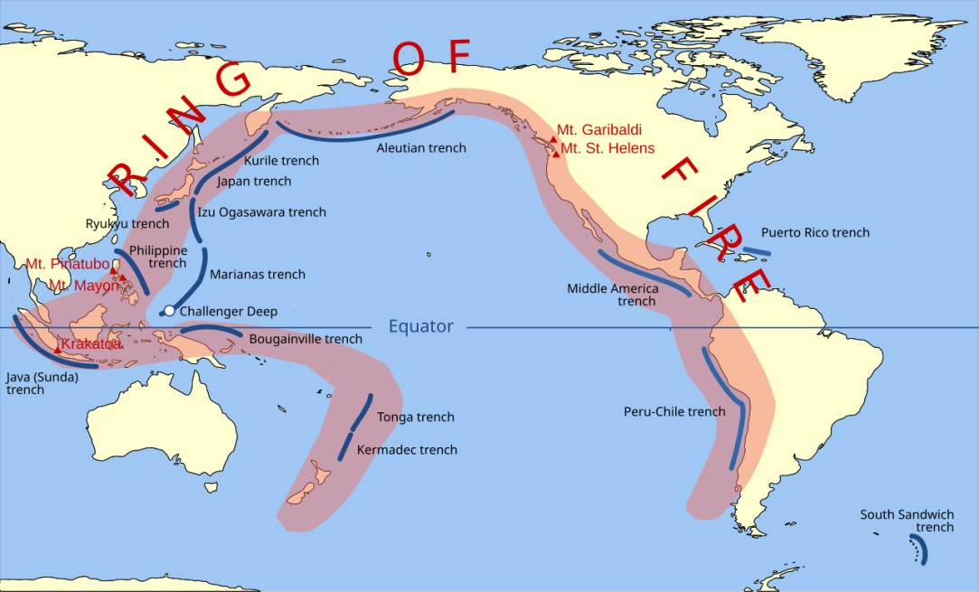
- Example: Pacific Ring of Fire.
- Convergent Boundaries: Common along subduction zones, where one plate is forced beneath another, generating intense volcanism.
2. The Pacific Ring of Fire
- The Ring of Fire is the most significant volcanic belt on Earth, a long chain of active volcanoes, earthquake zones, and subduction trenches surrounding the Pacific Ocean.
- It was formed primarily by the subduction of oceanic plates beneath continental plates.
- Distribution:
- Runs along the western coasts of North and South America,
- Continues along the eastern coasts of Asia, past New Zealand,
- Extends into the northern edge of Antarctica.
- Significance: Accounts for about 75% of the world’s active volcanoes and frequent seismic activity.
3. Earthquake–Volcano Relationship
- Along mid-oceanic ridges, earthquakes generally have shallow foci, associated with magma upwelling.
- Along convergent boundaries (e.g., the Alpine-Himalayan Belt and the Ring of Fire), earthquakes tend to be deep-seated, reflecting intense subduction processes.
4. Hotspot Volcanism
- Hotspots are volcanic regions found away from plate boundaries, where mantle plumes rise from deep within the Earth to create volcanoes.
- These are relatively fixed compared to moving tectonic plates, creating chains of volcanic islands.
- Examples:
- Hawaiian Islands (Pacific Ocean)
- Yellowstone Caldera (USA)
- Reunion Island (Indian Ocean)
Volcanic Landforms
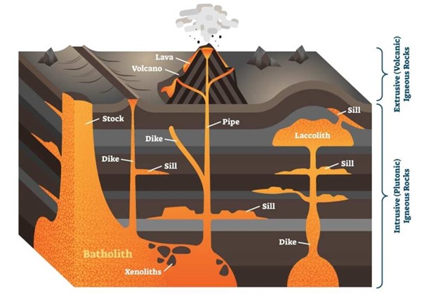
Volcanic landforms are shaped by the cooling, solidification, and emplacement of magma or lava. Depending on whether the molten material cools beneath the surface (intrusive landforms) or at the surface (extrusive landforms), different geological features are formed.
1. Intrusive Landforms
When magma cools and solidifies inside the Earth’s crust, it forms intrusive igneous bodies. These structures are not visible at the surface initially, but they may be exposed later due to erosion and denudation. The main types are:
a) Batholiths
- Definition: Extremely large, dome-shaped bodies of cooled magmatic material, often covering hundreds of square kilometers.
- Composition: Generally granitic in nature.
- Formation: Represent the solidified remnants of ancient magma chambers deep within the crust.
- Significance: Batholiths form the core of many mountain ranges (e.g., the Himalayas, Andes).
b) Laccoliths
- Definition: Dome-shaped intrusive bodies with a flat base and a convex top, connected to the magma source through a conduit.
- Formation: Created when magma intrudes between sedimentary layers, pushing the overlying strata upward.
- Examples: Found in the Karnataka Plateau (India).
c) Lopoliths
- Definition: Saucer-shaped intrusive bodies, formed when magma spreads laterally along weak sedimentary planes.
- Characteristics: Often have a depressed center, unlike laccoliths which are dome-shaped.
d) Phacoliths
- Definition: Lens-shaped, wavy masses of igneous rock found at the crest of anticlines or trough of synclines, typically associated with folded mountain belts.
- Significance: Indicate magma emplacement during crustal folding.
e) Sills and Sheets
- Sills: Thick, tabular intrusive bodies that form parallel to existing bedding planes of sedimentary rocks.
- Sheets: Thinner, horizontal deposits formed in a similar manner.
- Importance: Provide insights into magma intrusion during sediment deposition.
f) Dykes
- Definition: Vertical or steeply inclined walls of igneous rock formed when magma cuts across pre-existing rock layers.
- Appearance: Resemble walls of solidified lava.
- Example: Found extensively in Western Maharashtra, especially in the Deccan Trap region.
Extrusive Volcanic Landforms: These are created when magma erupts and cools above the Earth’s surface.
- Fissure Vents: These are long cracks in the Earth’s crustthat allow lava to flow out in a continuous stream, with minimal explosions.
- Conical Vents:These are the classic volcano shapes with a central vent. Violent eruptions of ash and lava build up around the vent, creating the cone-like form..
- Mid-Ocean Ridges: These underwater mountain rangeserupt frequently due to the constant seafloor spreading. The lava here is less viscous and flows easily, creating vast plains of basalt rock.
- Shield Volcanoes:These are broad, gently sloping volcanoes formed by fluid basaltic lava flows. They erupt less explosively than other types.
- Lava Plateaus: When large volumes of lava erupt and spread out over vast areas, they solidify to form extensive, flat plateaus. Colombia Plateau in the United Statesand the Deccan Plateau in India are examples of lava plateaus.
Calderas: These are large, cauldron-shaped depressions that form when the roof of a magma chamber collapses after a powerful eruption.
Lava Domes: As the name suggests, these are dome-shaped protrusions formed by the slow extrusion of viscous lava that cools and hardens around the vent.
Mantle Plumes and Hotspots
Apart from plate-boundary volcanism, certain volcanic features originate from deep-seated mantle dynamics:
a) Mantle Plumes
- Definition: Columns of hot, buoyant material rising from the deep mantle (D’’ layer near the core–mantle boundary).
- Role: Generate volcanic activity independent of plate boundaries.
- Process: As tectonic plates drift over these stationary plumes, chains of volcanoes are created.
b) Hotspots
- Definition: Volcanic regions fed by mantle plumes, located far from plate margins.
- Examples:
- Hawaiian Islands (Pacific Ocean) – Classic chain formed as the Pacific Plate moved over a plume.
- Yellowstone (USA) – Hotspot beneath continental crust, producing calderas.
- Iceland – A hotspot coinciding with the Mid-Atlantic Ridge.
- Galápagos Islands, Réunion, and Easter Island – Other prominent hotspots.
Role of Asthenosphere and Mantle Dynamics
- The Asthenosphere, lying just beneath the lithosphere, is a partially molten, ductile zone that allows tectonic plates to move.
- The D’’ layer near the core–mantle boundary plays a vital role in heat transfer and mantle convection.
- Mantle plumes originate here, rising upward to cause hotspot volcanism.
Earthquakes: Causes, Waves, and Geological Significance
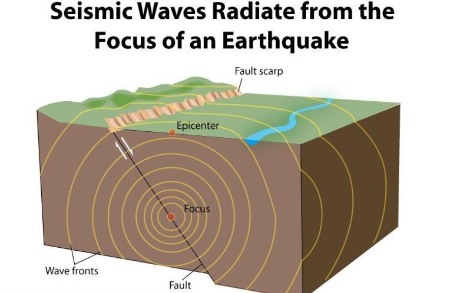
An earthquake is the sudden trembling or vibration of the Earth’s surface, caused by the abrupt release of stored energy in the lithosphere. This energy radiates outward in the form of seismic waves, which travel through the Earth’s interior and along its surface. Nearly all natural earthquakes originate within the upper 200 km of the lithosphere, making them key indicators of tectonic activity and internal Earth dynamics.
- Focus (Hypocentre): The point beneath the Earth’s surface where the earthquake originates.
- Epicentre: The point on the Earth’s surface directly above the focus, which experiences the first shocks and is generally the most affected area.
Seismic Waves
Earthquakes release different types of seismic waves, which differ in speed, motion, and destructive capacity.
1. Body Waves (Interior Waves)
Travel through the Earth’s interior and originate from the focus.
Primary Waves (P-Waves):
- Nature: Longitudinal waves where particles vibrate parallel to the direction of propagation.
- Speed: Fastest seismic waves; the first to be detected by seismographs.
- Medium: Can travel through solids, liquids, and gases.
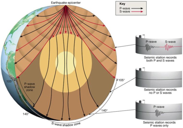
- Special Feature: Create a shadow zone between 105°–145° due to refraction in the liquid outer core.
Secondary Waves (S-Waves):
- Nature: Transverse waves with particles vibrating perpendicular to the direction of propagation.
- Speed: Slower than P-waves.
- Medium: Travel only through solids, blocked by liquids.
- Special Feature: Produce significant ground shaking; create a shadow zone beyond 105°.
2. Surface Waves (Most Destructive)
Travel along the Earth’s surface and cause maximum damage.
Love Waves (L-Waves):
- Move horizontally in a side-to-side fashion.
- Faster than Rayleigh waves, slower than S-waves.
- Cause strong lateral displacement, damaging infrastructure.
Rayleigh Waves (R-Waves):
- Exhibit a rolling motion combining longitudinal and transverse movements.
- Can travel through both solids and liquids.
- Produce a heaving and wave-like motion, often felt as the ground “rippling.”
Relative Speed Order: P-Waves > S-Waves > Love Waves > Rayleigh Waves
Seismic Shadow Zones
Shadow zones are areas where seismographs cannot detect direct seismic waves:
- P-Wave Shadow Zone: Between 105°–145° from the epicentre due to refraction by the liquid outer core.
- S-Wave Shadow Zone: Beyond 105°, since S-waves cannot penetrate the liquid outer core, leaving a much larger shadow area.
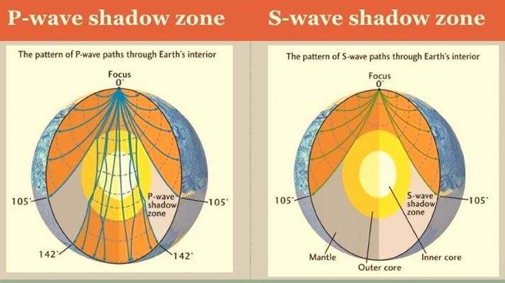
These patterns provided the earliest scientific evidence of the Earth’s layered internal structure.
Scales for Measuring Earthquakes
Earthquakes are measured in terms of both their magnitude (energy released) and intensity (impact on people and structures).
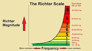
1. Richter Scale (Magnitude Scale)
- Developed in 1935 by Charles F. Richter.
- Measures the magnitude of an earthquake using a logarithmic scale.
- Each whole number increase represents a tenfold increase in wave amplitude and about 31 times more energy release.
- Formula:
M=log10( A/ A0)
- Where A = amplitude of seismic waves and A₀ = reference amplitude.
2. Moment Magnitude Scale (Mw)
- A modern scale that has largely replaced the Richter scale.
- Provides more accurate measurements for large earthquakes, as it considers:
- Fault slip,
- Area of rupture,
- Strength of the rocks involved.
- Widely used in scientific studies and international earthquake reporting.
3. Modified Mercalli Intensity Scale (MMI)
- Measures the intensity of an earthquake based on its effects on people, buildings, and the natural environment.
- Uses Roman numerals from I (not felt) to XII (total destruction).
- Example: The same earthquake may have different MMI values at different locations depending on distance from the epicentre and local geology.
Earthquakes are a direct consequence of plate tectonics and Earth’s internal dynamics. Their study not only helps us understand lithospheric processes but also provides vital insights into the Earth’s internal layers through seismic waves and shadow zones. For UPSC, earthquakes must be studied in connection with plate tectonic theory, seismic zones of India, disaster management strategies, and case studies of recent earthquakes