
Geomorphic Processes and Landforms
The Earth’s surface is shaped by a complex interplay of internal (endogenic) forces and external (exogenic) forces. These forces act over geological time scales, creating, modifying, and wearing down landforms.
- Endogenic Forces (Land-Building Forces): Operate from within the Earth, powered by internal energy sources.
- Exogenic Forces (Land-Wearing Forces): Operate at or near the Earth’s surface, drawing energy from the Sun and atmospheric dynamics.
Together, they constitute geomorphic processes, responsible for the dynamic and ever-changing nature of Earth’s topography.

Weathering
Weathering refers to the mechanical disintegration and chemical decomposition of rocks at or near the Earth’s surface, through the influence of climate, organisms, and environmental factors. It is essentially an in-situ (on-site) process, meaning that rocks are broken down in their original place without significant transportation.
Weathering plays a crucial role in shaping the Earth’s surface, contributing to soil formation, denudation processes, and the preparation of material for erosion, mass wasting, and deposition.
Factors Influencing Weathering
- Geology – Nature of the parent rock, mineral composition, structure, and porosity.
- Climate – Temperature variations, rainfall, humidity, and wind determine the type and intensity of weathering.
- Topography – Slope steepness and altitude influence water infiltration, drainage, and temperature regimes.
- Vegetation – Plant roots, organic acids, and microbial activity accelerate biological and chemical weathering.
Types of Weathering Processes
Weathering is classified into Chemical, Mechanical (Physical), and Biological processes.
1. Chemical Weathering
Chemical weathering alters the mineral composition of rocks due to chemical reactions, often accelerated by water, air, and temperature variations.
Major Processes:
Solution
- Minerals dissolve directly in water or weak acids.
- Example: Calcium carbonate (limestone) dissolving in carbonic acid → forms calcium bicarbonate.
Carbonation
- Atmospheric CO₂ combines with water to form carbonic acid, which reacts with carbonate minerals.
- Common in limestone regions, leading to karst topography (caves, sinkholes). [UPSC-2024]
Hydration
- Minerals absorb water and expand, increasing volume and causing disintegration.
- Example: Anhydrite → Gypsum (CaSO₄ + 2H₂O).
- Repeated hydration leads to granular disintegration and exfoliation.
Oxidation and Reduction
- Oxidation: Addition of oxygen to minerals (e.g., iron-bearing rocks → rust formation).
- Reduction: Occurs in waterlogged zones or below the water table, where oxygen is absent.
- Responsible for colour changes and weakening of rocks.
2. Mechanical or Physical Weathering
Mechanical weathering breaks down rocks into smaller fragments without altering their chemical composition. It relies primarily on temperature variations, pressure release, and mechanical stresses.
Key Processes:
Unloading and Expansion (Exfoliation):
- When overlying materials are removed (erosion), buried rocks expand, leading to sheeting and peeling.
- Creates large, rounded exfoliation domes (e.g., in granite terrains).

Temperature Changes and Expansion:
- Daily heating and cooling cause differential expansion in rock minerals.
- Prominent in arid and high-altitude regions.
Freezing, Thawing, and Frost Wedging:
- In cold regions, water enters cracks, freezes, and expands by ~9%, widening the fractures.
- Repeated cycles create frost wedging → breakage of rocks into angular fragments.
- Common in temperate and polar climates.

Salt Weathering:
- Salts in rocks expand due to hydration, thermal action, and crystallisation.
- Salt crystallisation is particularly destructive in desert climates.
Exfoliation Tor:
- Rounded boulders and rock piles formed by temperature-induced expansion and contraction.
3. Biological Weathering
Biological activity contributes to both mechanical disintegration and chemical decomposition of rocks.
Main Agents:
Organism Growth:
- Burrowing animals (e.g., earthworms, rodents) and insects expose new rock surfaces.
Root Pressure:
- Plant roots penetrate cracks, and as they grow, exert mechanical pressure, causing rocks to split apart.
Organic Matter Decay:
- Decomposition of plant and animal remains produces humic, carbonic, and other organic acids, which chemically weaken rocks.
Significance of Weathering
- Soil Formation: Weathering provides the parent material for soil.
- Landform Development: Prepares rocks for erosion and shapes landscapes.
- Mineral Concentration: Creates secondary mineral deposits (e.g., bauxite from laterisation).
- Ecological Balance: Releases nutrients essential for plant growth.
Erosion, Deposition, and Mass Movements
1.Erosion
Erosion is the process by which rock debris and soil materials are detached, transported, and worn down by geomorphic agents such as running water, glaciers, wind, waves, and groundwater. Unlike weathering, which is in-situ, erosion always involves movement and transportation of material.
Key Features:
- Agents of Erosion: Running water, glaciers, wind, waves, and groundwater.
- Mechanism: Abrasion (scraping of rock surfaces by debris carried in motion), attrition (mutual collision of particles), and hydraulic action (direct pressure exerted by moving agents).
- Relation with Weathering: Weathering prepares rock material for erosion but is not a mandatory prerequisite. Erosion can occur even in unweathered rock.
- Geographical Importance: Responsible for valley formation, canyon cutting, glacial troughs, dune creation, and shoreline shaping.
2.Deposition
Deposition is the laying down or accumulation of sediments transported by geomorphic agents when their energy decreases.
Key Features:
- Sequence: Materials are deposited in reverse order of size – coarser particles settle first, followed by finer particles.
- Agents of Deposition: Running water (alluvial plains, deltas), glaciers (moraines, drumlins), wind (loess, sand dunes), waves (beaches, spits, bars), and groundwater (stalactites, stalagmites).
- Geomorphic Significance: Deposition results in the construction of landforms, balancing the degradational impact of erosion.
3. Mass Movements:
Mass movements, also referred to as mass wasting, are the downslope movement of weathered rock debris, soil, or regolith under the direct influence of gravity. Unlike agents such as rivers, glaciers, or wind, these processes occur without any transporting medium, making them purely gravity-driven geomorphic processes. They act as a vital link between weathering (material preparation) and erosion (material removal and transportation).
Factors Favouring Mass Movements
Several natural and anthropogenic factors control the occurrence and intensity of mass movements:
- Weak and Weathered Materials: Highly weathered, fractured, or loosely consolidated rocks are more prone to slope failure.
- Steep Slopes: Steeper gradients increase gravitational pull, accelerating downslope movement. Mountainous regions are particularly vulnerable.
- Heavy Rainfall and Saturation: Intense or prolonged precipitation saturates soils, reduces cohesion, and increases pore-water pressure, making slopes unstable.
- Lack of Vegetation Cover: Vegetation provides root binding and reduces erosion. Areas with deforestation or sparse cover face higher risks.
- Seismic and Volcanic Activity: Earthquakes shake and destabilize slopes, while volcanic activity introduces loose debris and molten material, triggering avalanches or lahars.
- Human Activities: Road cutting, mining, construction, and reservoir-induced seismicity can destabilize slopes and induce mass movements.
Types of Mass Movements
Mass movements are broadly classified into slow movements (imperceptible but long-term) and rapid movements (sudden, destructive, and hazardous).
1. Slow Mass Movements
These are gradual, continuous, and long-duration movements, often unnoticed in the short term but capable of reshaping landscapes over centuries.
Creep
- The slowest type of mass movement, often occurring on moderately steep, soil-covered slopes.
- Triggered by freeze-thaw cycles, wetting and drying, thermal expansion, or root pressure.
- Over long periods, creep causes tilting of poles, fences, retaining walls, and bending of tree trunks.
Solifluction
- A specialized type of creep observed in cold, periglacial regions with permanently frozen subsoil (permafrost).
- Occurs when the upper active layer of soil thaws during summer, becoming waterlogged and slowly sliding downslope over the frozen sublayer.
- Also found in moist temperate climates, where prolonged rainfall saturates soils, causing slow downslope flow.
2. Rapid Mass Movements
These are sudden, short-lived, and highly destructive movements, common in humid, steep, and tectonically active regions.
Earthflow
- Involves the flow of water-saturated, clay-rich or silty soils down gentle to moderate slopes.
- Typically leaves behind tongue-shaped deposits.
- Often associated with deforestation, construction activity, or heavy rainfall.
Mudflow
- A more fluid and rapid form of earthflow, triggered by intense rainfall, cloudbursts, or volcanic eruptions.
- Moves like a stream of mud and debris down gullies and valleys.
- Lahars, volcanic mudflows, are a classic example (e.g., Mount Pinatubo, Philippines).
Debris Avalanche
- The fastest and most catastrophic type of mass movement, involving rock, soil, and debris rushing downslope at high speeds.
- Confined to narrow valleys or gullies, often resembling snow avalanches in velocity.
- Common triggers: earthquakes, volcanic eruptions, intense rainfall, or sudden slope collapse.
- Highly destructive due to their speed, volume, and energy, often sweeping away settlements and infrastructure.
Types of Rapid Mass Movements
Type | Material Involved | Speed | Key Characteristics |
Earthflow | Clay, silt | Slow | Occurs on low-angle terraces or hillsides; movement is sluggish and tongue-shaped. |
Mudflow | Mud (water-saturated weathered materials) | Rapid | Moves down channels like a stream of mud; triggered by heavy rainfall or cloudbursts. |
Debris Avalanche | Loose rocks, soil, and mixed debris | Very Rapid | Occurs on steep slopes; resembles snow avalanches; highly destructive. |
Landslides
A landslide refers to the rapid and noticeable downslope movement of rock, soil, or debris under the influence of gravity. Unlike mass movements involving saturated materials, landslides typically involve relatively dry debris and are strongly influenced by geology, slope, and climate.
Types of Landslides (Based on Movement of Material)
1. Slump
- Characterised by the slipping of rock debris in a rotational manner, moving backward relative to the slope.
- Involves a curved slip surface, often resulting in step-like landforms.
2. Debris Slide
- Involves the rapid rolling or sliding of unconsolidated debris downslope.
- Unlike slumps, there is no backward rotation of the material.
3. Rockslide
- Refers to the sliding of large rock masses along bedding planes, joints, or fault surfaces.
- Typically occurs in steep and fractured terrains.
4. Rockfall
- The free fall of detached rock blocks from steep cliffs or slopes.
- Material falls vertically or bounces while maintaining some distance from the slope surface.

Regional Vulnerability in India
Himalayas:
- Composed largely of sedimentary rocks and unconsolidated/semi-consolidated deposits.
- Coupled with steep gradients and active tectonics, this makes the Himalayas highly prone to frequent landslides.
Nilgiris (Tamil Nadu):
- Geologically more stable with hard crystalline rocks, but mechanical weathering due to temperature fluctuations weakens slopes.
- The region experiences intense rainfall over short periods, triggering slope failures.
- Hence, the Nilgiris are also recognised as a landslide-prone zone.
Stages of Development
Stage of River | Valley Shape | Channel Pattern | Other Features |
Youth | V-shaped, deep, narrow | Straight, with rapids and waterfalls | Steep slopes, interlocking spurs, gorges, little or no floodplain |
Mature | U-shaped, broader | Meandering, wider channel | Development of floodplains, oxbow lakes, river terraces, lateral erosion |
Old | Wide, shallow valleys | Highly meandering with many oxbow lakes | Extensive floodplains, deltas, braided streams, natural levees, meander scars |
Erosional Landforms by Running Water
Valleys:
- Evolution begins with tiny rills, which deepen into gullies, and eventually develop into broad valleys.
- Types:
- V-Shaped Valleys: Typical of youthful rivers, narrow and steep.
- Gorges: Deep, vertical-sided valleys cut into resistant rock.
- Canyons: Vast, steep-walled valleys, wider at the top than at the bottom, common in arid regions (e.g., Grand Canyon, USA).

Canyons and Gorges of India
Canyon/Gorge | River | State/UT | Nearest City/Town | Nickname / Special Feature |
Gandikota Canyon | Pennar | Andhra Pradesh | Kadapa / Jammalamadugu | “Grand Canyon of India” |
Bhedaghat Marble Rocks | Narmada | Madhya Pradesh | Jabalpur | Marble cliffs & Dhuandhar Falls |
Satanur Gorge | Pennar | Andhra Pradesh | Kadapa | Steep rock walls |
Chambal Ravines | Chambal | Madhya Pradesh, Rajasthan, Uttar Pradesh | Kota, Gwalior, Dholpur | Rugged ravines; linked to bandit history |
Papi Hills Gorge | Godavari | Andhra Pradesh, Telangana | Rajahmundry | Scenic gorge; part of Papikonda National Park |
Mekedatu Gorge | Kaveri | Karnataka | Kanakapura / Bengaluru | “Goat’s Leap” – river through narrow gorge |
Idukki Gorge | Periyar | Kerala | Idukki | Famous for Idukki Dam & natural beauty |
Stok Gorge | Indus | Ladakh | Leh | High-altitude gorge; trekking trails |
Lohit Gorge | Lohit | Arunachal Pradesh | Tezu | Rugged terrain of NE Himalayas |
Araku Valley Gorges | Varaha | Andhra Pradesh | Araku Valley | Picturesque valleys; waterfalls & tribal heritage |
Potholes and Plunge Pools
Potholes are cylindrical depressions formed on rocky streambeds due to the combined action of erosion, abrasion, and hydraulic action.
- As pebbles and boulders get trapped in small depressions, the swirling action of running water rotates them, thereby grinding and drilling the rock surface.
- Over time, these depressions become wider and deeper, contributing to the formation of pothole chains that may eventually merge into larger erosional forms.
- Example in India: Narmada River basin near Jabalpur shows well-developed potholes.

Plunge Pools are deep depressions formed at the base of waterfalls.
- They are created by the hydraulic force of falling water combined with the abrasion of transported sediments.
- The constant turbulence at the waterfall base weakens softer rock layers, leading to the formation of large pools.
- Examples: Plunge pool at Jog Falls (Karnataka) and Dhuandhar Falls (Madhya Pradesh).

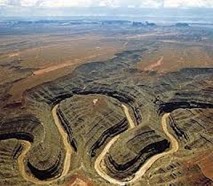
Incised Meanders
- Meanders that are cut deeply into the bedrock due to vertical erosion rather than lateral erosion. They are typical of rivers flowing through hard, resistant rocks.
- Rock Types: Commonly formed in sandstone, limestone, and granite, which resist lateral erosion and force rivers to entrench their meanders.
- Formation Mechanism:
- Rivers begin meandering on a gently sloping plain.
- Due to tectonic uplift or a drop in base level (sea/lake level), the river’s erosive energy is concentrated downwards.
- The result is deeply entrenched meanders cut into the bedrock, often creating canyons and gorges.
- Factors Influencing Incised Meanders:
- Tectonic Uplift: Uplifting land increases vertical erosion.
- Base Level Drop: Fall in sea level or local lake level enhances downward cutting.
- Rock Resistance: Hard rocks limit lateral erosion and enhance vertical entrenchment.
- Examples: Incised meanders of the Chambal River and Yamuna River valleys.
River Terraces
- Step-like surfaces representing former valley floors or floodplains of a river. They are formed when a river erodes vertically into its own floodplain, leaving remnants of older levels along the valley sides.
- Causes of Formation:
- Receding floodwaters after peak flows.
- Climatic fluctuations altering river discharge.
- Tectonic uplift raising land surfaces relative to river base level.
- Sea level changes, particularly for rivers draining into the oceans.
- Types of River Terraces:
- Paired Terraces: Present at the same height on both sides of a river valley, indicating uniform uplift.
- Unpaired Terraces: Found at different elevations on opposite banks or only on one side, indicating unequal uplift or irregular changes in discharge.
- Types of River Terraces:
- Significance:
- Provide evidence of paleo-climatic changes.
- Indicate past phases of river incision and tectonic activity.
- Offer fertile agricultural land due to old alluvial deposits (e.g., Gangetic plains).
- Significance:

Depositional Landforms Formed by Running Water
Running water not only erodes but also acts as a powerful agent of deposition, especially when the velocity of a river decreases and it loses the capacity to transport sediments. These depositional landforms reflect the combined influence of river load, velocity, gradient, and base level conditions.
1. Alluvial Fans
Alluvial fans are cone- or fan-shaped deposits that form where mountain streams, carrying coarse sediments such as gravel and sand, descend abruptly onto flatter plains. The sudden reduction in velocity forces the river to drop its heavy load, spreading sediments outward in a radial pattern.
Channel Pattern:
The streams flowing over fans often change course frequently due to sediment blockages. This results in the development of multiple shifting distributary channels.
Regional Variations:
- Humid Regions → Fans are broad, spread out, and have gentle slopes.
- Arid Regions → Fans are steep, with high cone-shaped deposits due to rapid sediment dumping.
Examples: Kosi River Fan (Bihar), Alluvial fans along the Siwalik foothills.

2. Deltas
Deltas are triangular or fan-shaped depositional landforms formed at river mouths, where rivers meet seas, oceans, or large lakes. Unlike alluvial fans, delta deposits are well-sorted and stratified.
Key Characteristics:
Deposits are arranged in three distinct layers:
- Topset beds → coarse sediments at the surface
- Foreset beds → inclined layers of medium material
- Bottomset beds → fine sediments settling in deeper water
Conditions Favourable for Delta Formation:
- A shallow sea or lake shore at the river mouth
- A long river course carrying medium-sized sediments
- Sheltered coastal conditions with minimal wave or tidal disturbance
- High sediment load, often due to erosion in upper catchments
Examples: Ganga–Brahmaputra Delta (world’s largest), Nile Delta, Mississippi Delta.

3. Floodplains
Floodplains are broad, flat stretches of land on either side of a river channel, built up by the deposition of sediments during floods.
Types of Floodplains:
- Active Floodplain → Located within the present channel zone, regularly replenished with new deposits.
- Inactive Floodplain → Older surfaces, slightly elevated, formed from previous flood deposits.
Special Case: In deltaic regions, floodplains are referred to as delta plains.
Examples: Indo-Gangetic Floodplain, Mississippi Floodplain.

4. Natural Levees and Point Bars
Natural Levees:
Raised embankments of coarse sediments formed along riverbanks during floods, when heavier materials settle closer to the channel.
- Profile: Steeper towards the river and gentler outward.
- Modification: Repeated breaches often break them into smaller mounds.
Examples: Natural levees along the Mississippi and Ganga rivers.
Point Bars (Meander Bars):
Crescent-shaped sand and gravel deposits formed on the inner convex bank of a meander, where water flow slows down.
- The outer concave bank simultaneously undergoes erosion, creating cut banks.
- These features are characteristic of large alluvial rivers.

5. Meanders
Meanders are loop-like bends commonly found in the course of rivers flowing across floodplains.
Mechanism of Formation:
- Erosion on the outer concave bank due to faster current.
- Deposition on the inner convex bank due to slower current.
Favourable Factors:
- Gentle channel gradients
- Presence of abundant, unconsolidated alluvial material
- Influence of the Coriolis force, aiding lateral movement of flow
Evolution:
With time, meanders may become exaggerated. When a loop is cut off, it creates an oxbow lake.
6. Oxbow Lakes
Oxbow lakes form when a meander loop is cut off from the main river due to deposition at its narrow neck, leaving behind a crescent-shaped water body.
Significance:
- Serve as freshwater wetlands, supporting biodiversity.
- Play a vital role in the hydrology and ecology of floodplains.
Examples: Common across the Ganga-Brahmaputra plains.

7. Braided Channels
A braided channel is a network of interwoven streams separated by sandbars, gravel, or small islands. It gives the appearance of braided hair.
Formation Conditions:
- Occurs where sediment load is high but discharge is relatively low.
- Frequent deposition and lateral erosion cause the river to split into multiple shifting channels.
Examples: Brahmaputra River near Assam, Indus River in Pakistan.

Groundwater and Karst Topography
Groundwater is a major agent of landform development, especially in regions dominated by calcium carbonate-rich rocks such as limestone, dolomite, and chalk. Through the processes of solution, erosion, and deposition, groundwater shapes a distinctive set of features collectively known as Karst Topography.
Karst landscapes are most common in areas where rocks are:
- Permeable → allowing easy infiltration of water
- Well-jointed or fractured → providing passageways for circulation
- Highly soluble → especially carbonate rocks like limestone
Groundwater Processes
Solution (Chemical Weathering)
Rainwater absorbs carbon dioxide (CO₂) from both the atmosphere and soil, forming a weak carbonic acid. This acidic water dissolves calcium carbonate rocks such as limestone, both at the surface and underground.
Factors influencing dissolution:
- Temperature of groundwater → higher temperatures accelerates chemical reactions.
- Rock structure → presence of joints, fractures, and bedding planes facilitates infiltration.
- Time of contact → prolonged interaction between acidic water and rock enhances dissolution.
Erosional Landforms of Karst Regions
Groundwater erosion in limestone terrains gives rise to unique Karst features:
- Swallow Holes (Sink Points):
Small to medium circular depressions on the surface, formed where streams or rainwater directly sink into limestone. - Sinkholes (Dolines):
- Swallow Holes (Sink Points):
- Solution Sinkholes → gradually formed by continuous dissolution of limestone.
- Collapse Sinkholes → created when the roof of an underground cave collapses, leaving behind a steep-sided funnel.
- Valley Sinks (Uvalas):
Large, elongated depressions formed when multiple sinkholes merge together, often resembling valleys. - Lapies (Lapiaz):
Irregular, grooved, and ridged limestone surfaces shaped by differential solution along parallel joints. - Caves and Caverns:
Formed when groundwater enlarges underground passages. Some caves may open at both ends, functioning like natural tunnels. - Ponors:
Vertical shafts or pipe-like openings connecting surface depressions with underground drainage systems. - Natural Bridges:
Created either by the collapse of a cave roof or when a surface stream goes underground, leaving behind an arch of rock. - Limestone Pavement:
Characterized by grikes (solution-enlarged trenches) and clints (isolated rectangular blocks). Common in glaciated limestone regions. - Dry Valleys (Coombes):
Valleys in chalk or limestone regions that once carried surface streams but now remain dry due to complete underground drainage.
- Valley Sinks (Uvalas):
Depositional Landforms of Karst Regions
When groundwater carrying dissolved calcium carbonate loses its carrying capacity (due to evaporation, cooling, or obstruction), minerals precipitate and form spectacular underground features:
Stalactites:
- Icicle-shaped deposits hanging from cave ceilings, broad at the base and tapering downward.
Stalagmites:
- Conical formations rising upward from cave floors, formed by water dripping from above.
Pillars (Columns):
- Created when stalactites and stalagmites meet and fuse together.
Dripstones:
- A general term for all calcite formations created by dripping water.
Curtains/Drapes:
- Thin, wavy deposits hanging from cave ceilings, resembling folded drapery.
Helictites and Heligmites:
- Rare twisted or sideways-growing formations; sometimes globular forms known as globulites develop.
Flowstones:
- Smooth, sheet-like deposits formed when water flows slowly over cave walls or floors, leaving behind calcite layers.
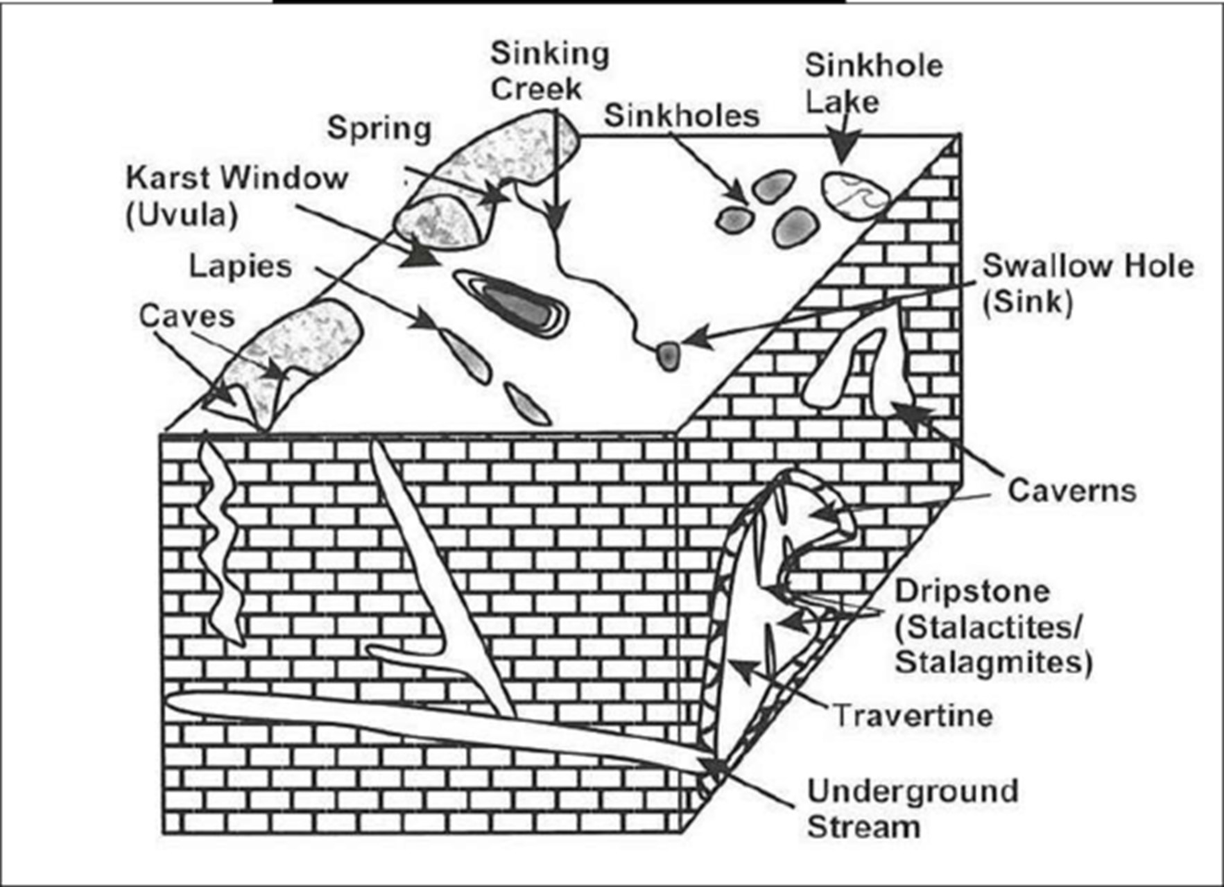
Karst topography is a striking example of how groundwater shapes landscapes through both erosion and deposition. From deep caves and swallow holes to delicate dripstone formations, these landforms highlight the intricate balance between water, rock, and time. They not only influence drainage patterns and ecology but also create some of the world’s most spectacular natural wonders.
Glaciers
Glaciers are large moving masses of ice and snow that slowly flow over land under the influence of gravity. They are powerful geomorphic agents capable of eroding, transporting, and depositing sediments, thereby shaping distinct landforms. Today, glaciers cover about 10% of Earth’s surface, but during the Pleistocene Ice Age, they extended over nearly one-third of the planet.
Glaciers are broadly classified as:
- Continental Glaciers – Vast ice sheets covering large plains and plateaus (e.g., Greenland, Antarctica).
- Valley and Piedmont Glaciers – Confined to mountainous regions, flowing through valleys or spreading at mountain bases.
Glacial Erosional Processes
Glaciers erode through two main mechanisms:
- Plucking: The glacier freezes onto joints and cracks of underlying rocks, tearing out rock blocks and dragging them away.
- Abrasion: Rock fragments embedded in the glacier act like sandpaper, scratching, polishing, and scouring the valley floor.
Erosional Landforms of Glaciers
Glaciers erode the underlying surface through plucking (tearing out of rock fragments) and abrasion (scraping and polishing). This dual process produces a variety of erosional features:
Cirques (Corries):
- Steep-walled, amphitheatre-like depressions at the head of glacial valleys, carved by intense erosion. Often contain tarn lakes when filled with water.
Example – Chandra Taal, Himachal Pradesh.
- Steep-walled, amphitheatre-like depressions at the head of glacial valleys, carved by intense erosion. Often contain tarn lakes when filled with water.
Arêtes:
- Sharp, knife-edged ridges formed when two cirques cut back into opposite sides of a mountain.
Horns (Pyramidal Peaks):
- Angular, pyramid-shaped peaks created when three or more cirques erode a mountain summit.
Example – The Matterhorn in the Alps.
- Angular, pyramid-shaped peaks created when three or more cirques erode a mountain summit.
Bergschrund:
- A deep vertical crevasse at the head of a glacier, marking the separation of moving glacier ice from stagnant snowfield ice.
Glacial Valleys / U-shaped Troughs:
- Unlike river valleys (V-shaped), glacial valleys are broad-bottomed and steep-sided. Key associated features include:
- Ribbon or Finger Lakes: Long, deep lakes occupying glacial troughs (e.g., Kashmir Himalayas).
- Hanging Valleys: Tributary valleys perched above the main trough, often giving rise to waterfalls (e.g., Har-Ki-Doon Valley, Uttarakhand).
- Fjords: Submerged U-shaped valleys filled by the sea, forming deep, narrow inlets (e.g., Norway, New Zealand).
Roche Moutonnée:
- Small hummocks of resistant rock with a smooth, polished stoss side (upstream) and a rough, plucked lee side (downstream).
Crag and Tail:
- A hard rock outcrop (crag) with a tapering ridge of softer debris (tail) eroded in the direction of ice flow.
Nunataks:
- Isolated rocky peaks protruding above surrounding ice fields, resembling islands in a sea of ice.
Depositional Landforms of Glaciers
As glaciers retreat, they deposit a mix of unsorted and stratified materials, giving rise to distinctive landforms:
Glacial Till:
- Unsorted debris of varying sizes – clay, sand, gravel, and boulders – left directly by melting ice.
Outwash Deposits:
- Well-sorted sediments deposited by meltwater streams, forming stratified layers.
Moraines:
- Ridges or mounds of glacial till. Types include:
- Terminal Moraine – Marks the furthest point of glacier advance.
- Lateral Moraine – Deposited along glacier margins.
- Medial Moraine – Found at the center where two glaciers meet.
- Ground Moraine – Irregular till sheet left on the valley floor after glacier retreat.
- Ridges or mounds of glacial till. Types include:
Eskers:
- Long, winding ridges of sand and gravel deposited by streams flowing beneath melting glaciers.
Outwash Plains:
- Broad, flat plains formed by glacio-fluvial deposits, often resembling alluvial fans but at a much larger scale.
Drumlins:
- Smooth, oval-shaped hills of till aligned with glacier movement, often occurring in clusters and creating a “basket of eggs” topography.
Kettle Lakes:
- Depressions formed when stagnant ice blocks embedded in till melt, leaving behind water-filled hollows.
Fjords (as depositional features):
- In high-latitude coasts, submerged glacial valleys filled with seawater, bordered by steep cliffs.

Significance of Glacial Landforms
- Serve as geological evidence for reconstructing past Ice Ages and climatic changes.
- Regulate hydrology by storing water in glacial lakes and releasing it seasonally.
- Provide fertile soils (glacial till) in temperate regions, aiding agriculture.
- Offer unique habitats and biodiversity hotspots in alpine and polar ecosystems.
- Have immense economic and cultural value through tourism (fjords, alpine peaks) and mineral deposits.
Coastal Landforms
Coasts are the dynamic interfaces between land and sea, constantly modified by the action of waves, tides, currents, winds, and sediment supply. The evolution of coastal landforms depends on the geology of the coastline, wave energy, and sea-level changes. Coastal geomorphology can be broadly divided into erosional features (where wave energy dominates) and depositional features (where sediment supply and deposition dominate).
Processes Shaping Coastal Landforms
- Hydraulic Action – Force of breaking waves compresses air in cracks of rocks, causing erosion.
- Abrasion (Corrasion) – Pebbles, sand, and boulders carried by waves grind against coastal rocks, deepening erosion.
- Attrition – Rock fragments collide, breaking into smaller, rounded pebbles and sand.
- Corrosion (Solution) – Seawater dissolves soluble rocks such as limestone and chalk, leading to chemical weathering.
Types of Coasts
Coastal landscapes are shaped by the interaction of land, sea, and geological processes. Depending on whether erosion or deposition dominates, coasts may be broadly classified into High Rocky Coasts and Low Sedimentary Coasts.
1. High Rocky Coasts
Dominant Features:
These coasts are irregular, rugged, and steep, primarily formed by wave erosion acting on resistant rocks. They often present dramatic scenery where land meets the sea.
Landforms Created:
- Cliffs → steep rock faces formed by continuous pounding of waves.
- Sea Caves → hollow openings carved at the base of cliffs.
- Arches → formed when caves on opposite sides of a headland meet.
- Stacks → isolated vertical rock columns left behind after arch collapse.
- Fjords → deep, narrow inlets created when glaciers carve valleys later submerged by the sea.
Processes at Work:
- Wave erosion → constant pounding of waves weakens rocks.
- Abrasion (Corrasion) → mechanical scraping by rock fragments carried by waves.
- Corrosion (Solution) → chemical action of seawater dissolving minerals.
Examples:
- Konkan Coast (West Coast of India) → rugged cliffs and headlands.
- Norway (Fjord Coasts) → spectacular glacier-carved inlets.
- Patagonia, Chile → dramatic rocky shoreline with fjords and channels.
2. Low Sedimentary Coasts
Dominant Features:
These coasts are smooth, gently sloping, and straight, shaped mainly by deposition of sediments brought by rivers, waves, and longshore currents. They often support fertile agricultural lands and dense human settlements.
Landforms Created:
- Coastal Plains → flat stretches of land bordering the sea.
- Beaches → sandy or pebbly shores built by wave deposition.
- Sandbars → ridges of sand deposited parallel to the coast.
- Spits → narrow sand ridges projecting into the sea, formed by longshore drift.
- Lagoons → shallow water bodies separated from the sea by sandbars or spits.
- Deltas → fan-shaped deposits at river mouths.
Examples:
- Coromandel Coast (East Coast of India) → depositional features like beaches and lagoons.
- Gulf Coast of the USA → extensive coastal plains and deltaic formations.
Coastal Erosional Landforms
- Capes and Bays: Alternate hard and soft rock bands create headlands (capes) and inlets (bays). Example: Konkan coast of Maharashtra.
- Wave-Cut Cliffs: Steep rock faces formed where waves erode the base of coastal rocks, leading to cliff retreat.
- Wave-Cut Platforms/Terraces: Flat rock surfaces at the base of cliffs formed due to continuous undercutting.
- Caves: Formed when waves enlarge cracks in cliffs.
- Arches: Form when caves on opposite sides of a headland merge.
- Sea Stacks: Isolated vertical rock columns, once connected to cliffs but separated by erosion.
- Stumps: The final stage of stack erosion, where only small rock remnants remain above sea level.
Coastal Depositional Landforms
- Beaches: Accumulation of sand, pebbles, or shingle along the coast. They are dynamic features, changing seasonally due to wave action.
- Dunes: Wind-blown sand deposited inland of beaches, forming ridges parallel to the shoreline.
- Offshore Bars: Submerged ridges of sand and shingle parallel to the coast, acting as natural wave barriers.
- Barrier Bars/Barrier Islands: Offshore bars that have risen above sea level, forming elongated islands parallel to the coast.
- Spits: Narrow extensions of sand or shingle projecting into the sea, created by longshore drift. When spits close off bays, lagoons are formed.
- Tombolos: Natural depositional features connecting an island to the mainland through sediment accumulation.
- Lagoons: Shallow water bodies separated from the sea by spits, sandbars, or barrier islands; often brackish in nature.
- Estuaries: Funnel-shaped drowned river valleys where freshwater mixes with seawater. Examples: Hooghly Estuary (India), Thames Estuary (UK).
- Mudflats: Broad, flat, muddy areas exposed during low tide, found in sheltered estuaries.
- Salt Marshes: Coastal wetlands dominated by salt-tolerant vegetation, formed by fine sediment deposition in tidal zones.

Significance of Coastal Landforms
- Economic Importance: Beaches and estuaries are centers of fishing, ports, and tourism.
- Ecological Role: Lagoons, estuaries, and salt marshes are biodiversity hotspots and nurseries for marine life.
- Hazard Regulation: Offshore bars, dunes, and mangroves act as natural buffers against tsunamis and storm surges.
- Cultural and Heritage Value: Coastal cliffs, fjords, and beaches often hold religious, cultural, and tourism significance.
Straits and Isthmuses
Strait
A strait is a naturally formed narrow waterway that connects two larger water bodies, such as seas or oceans. Straits are of immense strategic and economic importance, as they often serve as key routes for navigation, trade, and military movement.
Example: The Palk Strait, which separates India and Sri Lanka, historically formed part of Adam’s Bridge (now submerged).

Isthmus
An isthmus is a narrow strip of land that connects two larger landmasses while being bordered by water on both sides. Isthmuses serve as natural bridges for the movement of people, animals, and goods, and they also act as vital links between ecosystems.
Geographical and Historical Significance:
- Function as strategic passageways for human migration and trade.
- Often modified for transportation, with canals cutting across them for faster sea routes.
- Formed by tectonic movements, sediment deposition, or volcanic processes.
Famous Examples:
- Isthmus of Panama → connects North and South America; separates the Pacific and Atlantic Oceans; home to the world-famous Panama Canal.
- Isthmus of Suez → links Africa and Asia; site of the Suez Canal, one of the busiest shipping routes in the world.
- Kra Isthmus → connects Thailand with the Malay Peninsula.

Difference between Gulf and Bay
Feature | Gulf | Bay |
Size and Shape | Generally larger and deeper indentations of the coastline. | Typically smaller and shallower compared to gulfs. |
Degree of Enclosure | More open connection to the ocean or sea. | Often have a narrower entrance, giving a more enclosed appearance. |


Winds and Desert Landforms
Wind is a dominant geomorphic agent in arid and semi-arid regions, particularly in hot deserts where vegetation cover is minimal and loose sediments are easily mobilised. Wind acts both as an erosional and a depositional force, shaping a wide variety of desert landscapes.
The two principal mechanisms of wind erosion are:
- Deflation – The lifting and removal of fine dust, silt, and sand particles from the surface. This results in the lowering of land surfaces and the creation of depressions.
- Abrasion/Impact – The mechanical wearing down of rock surfaces as sand grains are hurled against them, functioning like a natural sandblasting process.
Types of Desert Landscapes
- Hamada (Rocky Deserts): Dominated by bare, exposed bedrock surfaces, left behind after fine particles are blown away by wind.
- Reg (Stony Deserts): Surfaces covered with closely packed angular gravel or pebbles.
- Erg (Sandy Deserts): Vast sand-covered regions (ergs are also called koums in Turkestan).
- Badlands: Intensely eroded terrains with gullies, ravines, and steep slopes, caused by occasional torrential rainfall.
- Mountain Deserts: Occur in highlands, plateaus, or mountain ranges where aridity combines with rugged relief.
Erosional Landforms of Deserts
The action of deflation (removal of fine particles) and abrasion (sand-blasting effect of winds carrying dust and sand) shapes a wide range of erosional landforms in deserts. These landforms are the result of long-term processes operating under extreme aridity, high diurnal temperature range, and minimal vegetation cover.
1. Pediments and Pediplains
- Pediments are gently sloping rock-cut surfaces that develop at the foot of steep mountains or hills. They form due to a combination of sheet flooding, lateral erosion by ephemeral streams, and wind action.
- Over time, pediments expand and coalesce, leading to the gradual retreat of mountains and the isolation of inselbergs (residual hills).
- Pediplains represent the final stage of this erosion, where vast, nearly featureless plains emerge after prolonged denudation.
- Significance: Pediplains are evidence of the long-term degradation of relief in arid and semi-arid regions.
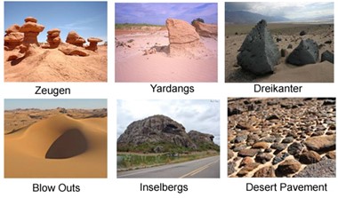
2. Zeugen
- Zeugen are tabular ridges consisting of a hard resistant cap rock overlying softer strata.
- Wind abrasion preferentially erodes the underlying softer layers, producing deep furrows. The harder cap rock remains elevated as ridges.
- Example: Zeugen are typically seen in Sahara Desert landscapes.
3. Yardangs
- Yardangs are streamlined ridges carved parallel to prevailing wind directions.
- They form when alternating hard and soft rock bands are subjected to wind abrasion. Softer layers wear down faster, leaving long, sharp ridges.
- Yardangs can be tens of metres high and kilometres long.
- Examples: Common in Egypt’s Western Desert and parts of Central Asia.
4. Playas
- Playas are shallow, flat-floored depressions found in desert basins.
- During rainfall, they may temporarily fill with water, but due to intense evaporation, they leave behind saline deposits such as gypsum, halite, and other evaporites.
- Significance: Playas are important sources of salt and chemical deposits and often evolve into saline flats.
- Examples: Rann of Kutch (India), Great Salt Lake basin (USA).
5. Mesas and Buttes
- Mesas: Flat-topped, table-like landforms with steep sides, formed due to horizontal layering of resistant rocks over softer rocks.
- Buttes: Smaller remnants of mesas, reduced by prolonged erosion.
- Formation Mechanism: Wind abrasion combined with water erosion removes softer rocks while leaving behind resistant cap rock.
- Examples: Famous in the Colorado Plateau (USA) and Deccan regions.
6. Inselbergs
- Inselbergs are isolated, steep-sided hills or domes, usually composed of hard rocks such as granite or gneiss.
- They are the residual remnants of ancient plateaus that have undergone prolonged weathering and erosion.
- Examples: Inselbergs of Southern Africa and Ayers Rock (Uluru), Australia.
7. Deflation Hollows
- Formed when winds blow away unconsolidated sediments, lowering the ground surface.
- Over time, these hollows may intersect the water table, creating oases that become centres of life and settlement in deserts.
- Examples: The Qattara Depression in Egypt, one of the largest deflation hollows in the world.
8. Mushroom, Table, and Pedestal Rocks
- Shaped by differential wind erosion where the lower portions erode faster due to sand-laden winds near the ground.
- Mushroom Rocks: Narrow stalk with a rounded top, resembling a mushroom.
- Table Rocks: Broad, flat tops supported by narrow bases.
- Pedestal Rocks: Pillar-like features standing tall due to resistant rock layers.
- Examples: Found in Thar Desert (India) and the Sahara Desert.
9. Badland Topography
- A rugged, highly dissected terrain with gullies, ravines, and ridges caused by intense water erosion in semi-arid deserts.
- Sparse vegetation and easily erodible rocks accelerate the development of this hostile landscape.
- Examples: Chambal Ravines (Madhya Pradesh), parts of Ladakh and Kutch, and Dakota Badlands (USA).
- Significance: Badlands represent extreme erosion and are unsuitable for agriculture or habitation.
Depositional Landforms of Deserts
1. Sand Dunes
Form when wind velocity decreases, leading to the accumulation of sand. Their shape and orientation depend on wind direction, intensity, and sand supply.
- Barchans: Crescent-shaped dunes with horns pointing downwind.
- Parabolic Dunes: Crescent-shaped but with horns pointing upwind, often stabilised by vegetation.
- Seif Dunes: Long, narrow dunes with only one wing, formed under shifting wind conditions.
- Longitudinal Dunes: Long ridges running parallel to prevailing winds, formed where sand supply is limited.
- Transverse Dunes: Ridges oriented perpendicular to wind direction, formed where sand supply is abundant.
2. Bajadas
- Gently sloping plains formed when alluvial fans from adjacent streams merge together at the foothills.
- They are transitional features between pediments and playas.

Significance of Wind-Shaped Landforms
- Climatic Indicators: Reveal the intensity of aridity and wind action in different regions.
- Economic Value: Playas provide salt, gypsum, and other evaporite deposits; dunes may act as groundwater traps.
- Ecological Importance: Sand dunes often support specialised desert vegetation and act as natural barriers against desertification.
- Cultural Importance: Several wind-shaped features (e.g., mushroom rocks, mesas) are tourist attractions and hold cultural heritage value.
Plateaus
A plateau is a large flat-topped tableland with steep sides, rising abruptly above the surrounding lowlands. Plateaus cover nearly one-third of the Earth’s land surface and form one of the four major landforms, alongside mountains, plains, and hills.
- Plateaus may be young (rugged, high, dissected) or old (eroded, with subdued relief).
- They are often referred to as “storehouses of minerals”, as rich deposits of iron ore, coal, copper, bauxite, gold, and diamonds are found in them.
- Many of the world’s important mining regions are located in plateau areas.
- Plateaus are also agriculturally significant; while arid plateaus are poor in fertility, volcanic plateaus such as the Deccan Plateau are extremely fertile due to basaltic soils.
- Rivers cutting through plateaus form deep valleys, gorges, and canyons (e.g., Columbia River Gorge, USA; Narmada Valley, India).
Types of Plateaus
Type of Plateau | Formation / Characteristics | Examples |
Tectonic Plateaus | Formed by uplift of Earth’s crust due to tectonic forces, often during slow collision of plates. | Tibetan Plateau (India–China), formed by collision of Indian & Eurasian Plates |
Volcanic Plateaus | Created by successive lava flows spreading over large areas; usually rich in black soil, supporting agriculture. | Deccan Traps (India), Columbia Plateau (USA) |
Intermontane Plateaus | Plateaus enclosed by fold mountains; often the highest and most extensive. | Tibetan Plateau (between Himalayas & Kunlun), Mongolian Plateau |
Dissected Plateaus | Shaped by erosion and denudation over time; rugged relief with valleys and gorges. | Colorado Plateau (USA) – carved by Colorado River into the Grand Canyon |
Continental Plateaus | Large plateaus lying far from mountains; bordered by plains or seas on all sides. | Antarctic Plateau (East Antarctica) |
Oceanic Plateaus | Located on the ocean floor; mostly formed by submarine volcanism. | Caribbean Plateau, Mid-Pacific Mountains |
Piedmont Plateaus | Border mountains on one side and plains or oceans on the other. | Patagonian Plateau (Argentina) – in the rain shadow of the Andes |
Major Plateaus of the World
Plateau | Location | Key Features | Special Notes |
Tibetan Plateau | China, Nepal, India, Bhutan, Tajikistan, Kyrgyzstan | Largest & highest plateau; lies between Himalayas (S) & Taklamakan Desert (N) | Known as “Roof of the World”; Third Pole due to massive ice reserves |
Arabian Plateau | Western Asia | Very arid climate, low rainfall | Rich in petroleum reserves |
Pamir Plateau | Tajikistan, China, Afghanistan | At junction of Himalayas, Tian Shan, Karakoram, Kunlun, Hindu Kush, Suleiman ranges | Also called “Roof of the World” |
Great Basin Plateau | USA (Nevada, Utah, California) | Largest intermontane plateau in North America | Features endorheic basins (inland drainage) |
Colorado Plateau | USA | Deep canyons carved by Colorado River | Home to Grand Canyon |
Columbian Plateau | USA (between Rockies & Cascades) | Basaltic lava plateau, mineral-rich | Extensive volcanic features |
Ethiopian Highlands | Ethiopia (Africa) | Highest plateau of Africa; volcanic origin | Peak: Ras Dashan (4,620 m); cool despite equatorial position |
East African Plateau | Uganda, Kenya, Tanzania | Rift valleys & large lakes (e.g., Lake Victoria) | Fertile highlands, tectonically active |
Katanga Plateau | DR Congo | Rich in cobalt, copper, diamonds | Major mineral-producing region |
Adamawa Plateau | Cameroon, Nigeria, Central African Republic | Covered by savanna vegetation | Rich in bauxite deposits |
Western Plateau | Australia (2/3rd area) | Desert/semi-desert plateau | Rich in gold & iron ore; includes Kimberley Plateau |
Anatolian Plateau | Turkey (Asia Minor) | Lies between Pontic & Taurus Mountains | Crossed by Tigris & Euphrates; Angora goats found |
Patagonian Plateau | Argentina (South America) | Piedmont plateau; arid & rain-shadow type | Important for sheep rearing |
Mascarene Plateau | Indian Ocean (Seychelles–Mauritius) | Submerged plateau | Marine biodiversity hotspot |
Deccan Plateau | Southern India | Between Western & Eastern Ghats; slopes eastward | Formed by Deccan Traps; rich in basaltic soils & minerals |

Types of Depositional Plains:
1. Riverine or Alluvial Plains
- Formed by deposition of sediments carried by rivers over time.
- Among the most fertile and agriculturally productive plains in the world.
- Characterized by features like floodplains, levees, meanders, oxbow lakes, and deltas.
- Examples: Indo-Gangetic Plains (India, Pakistan, Bangladesh), Mississippi Plains (USA), Nile Valley (Egypt).
2. Lacustrine Plains (Lake Plains)
- Formed by the infilling of lakes with sediments brought by streams and rivers.
- These plains are usually flat-floored and highly fertile.
- Example: Kashmir Valley (India), Swiss Lake Plains (Switzerland).
3. Glacial or Drift Plains
- Created by glacial deposition, where ice sheets and glaciers retreat, leaving behind till, moraines, and outwash plains.
- Such plains are common in high latitude regions.
- Examples: Northern European Plain, Canadian Shield glacial plains.
4. Loess Plains
- Formed by wind deposition of fine silt and dust particles, often transported over long distances.
- These plains are extremely fertile, as loess soils are rich in minerals.
- Examples: Loess Plateau of China, Mississippi-Missouri Loess Plains (USA), Northern France and Germany.

Significance of Plains
- Agriculture: Fertile soils and abundant water make plains the breadbaskets of nations (e.g., Indo-Gangetic Plains, Prairies).
- Settlement: Flat land encourages dense population and urbanization.
- Transport: Easier construction of roads, railways, and canals compared to mountains and plateaus.
- Economic Resources: Plains often contain rich alluvial deposits, oil fields, and groundwater reserves.
- Cultural Importance: Historically, most ancient civilizations (Indus, Mesopotamian, Egyptian, Chinese) flourished in fertile plains.