
Chronological Phases of Harappan Civilization
The Harappan Civilization is generally divided into three distinct phases:
1. Early Harappan or Formative Phase (6000 BCE – 2600 BCE)
- Characterized by the gradual emergence of urban planning, agriculture, and trade networks.
2. Mature Harappan or Urban Phase (2600 BCE – 1900 BCE)
- Marked by fully developed cities, advanced town planning, drainage systems, standardized weights and measures, and a flourishing economy.
3. Late Harappan or Post-Urban/Decline Phase (1900 BCE – 1300 BCE)
- This phase reflects the gradual decline of urban centers, with signs of ruralization and reduced trade.
The term “Harappan Culture” is most commonly used to refer specifically to the Mature Urban Phase, due to its extensive archaeological footprint and high level of urban sophistication.
Geographical Extent of the Indus Valley Civilization
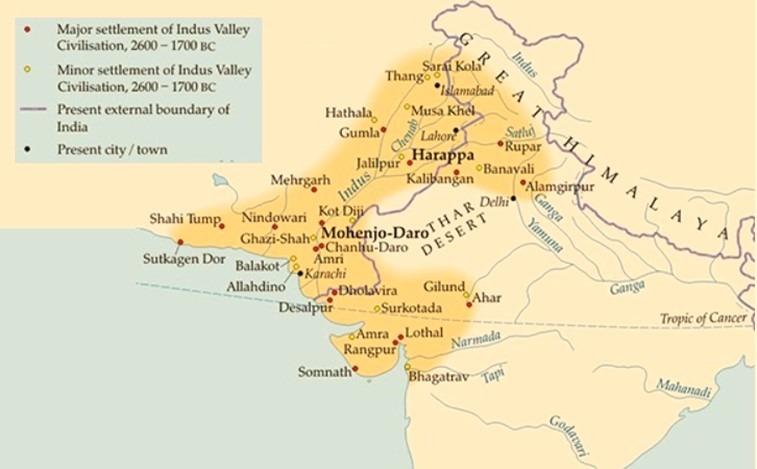
The Indus Valley Civilization (IVC), one of the world’s earliest urban cultures, spanned a vast geographical area of approximately 1.5 million square kilometers, making it the largest Bronze Age civilization of its time.
Territorial Coverage
The civilization extended across:
- Northwest India
- Pakistan
- Afghanistan
Boundaries and Extent
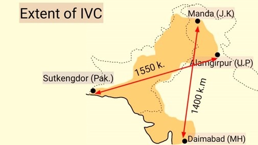
- Western Limit: The civilization extended as far west as Sutkagendor, a coastal settlement in southern Balochistan (Pakistan).
- Eastern Limit: The easternmost site was Alamgirpur, located in Meerut district, Uttar Pradesh.
- Northern Limit: The site of Mandain Jammu & Kashmir marked the northern boundary.
- Southern Limit: Initially believed to reach Bhagatravin the Narmada estuary of Gujarat, further discoveries at Daimabad in Maharashtra—along the Pravara River—indicated an even broader southern expansion, with finds such as Bronze figurines.
Prominent Harappan Sites in India
- Gujarat: Lothal, Dholavira
- Haryana: Rakhigarhi(India’s largest Harappan site)
- Jammu & Kashmir: Manda
- Maharashtra: Daimabad(southernmost extent)
- Rajasthan: Kalibangan
- Uttar Pradesh: Alamgirpur
Key Facts
Southernmost Site:
- Daimabadon the banks of the Godavari River basin, marking the furthest reach of the civilization in the Deccan region.
Total Sites Discovered:
- Over 2,000Harappan sites have been identified across the region.
Five Largest Sites:
1. Mohenjo-daro(Pakistan)
2. Harappa(Pakistan)
3. Ganweriwala(Pakistan)
4. Rakhigarhi(Haryana, India)
5. Dholavira(Gujarat, India)
Cultural Core
The heartland of the civilization was situated in the fertile regions of Sindh and Punjab (then part of undivided India), from which the civilization gradually radiated in all directions, shaping the cultural and urban fabric of the subcontinent.
Major Sites of the Harappan Civilization:
Harappa
Discovered in the 1920s by archaeologists Daya Ram Sahni, M.S. Vats, and Mortimer Wheeler, Harappa was the first major site unearthed, located on the left bank of the Ravi River in the Montgomery district of Western Punjab (now in Pakistan). Covering about 150 hectares, Harappa featured a fortified citadel to the west and a lower town to the southeast.
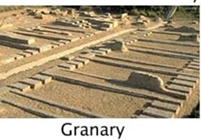
The site revealed advanced urban planning, including mud-brick fortifications, towers, gateways, workshops for shell, agate, and copper artifacts, and domestic infrastructure like houses, drains, and wells. Harappa is often referred to as the “City of Granaries,” with 12 granaries discovered, possibly to store surplus grain due to seasonal fluctuations or population needs. Unique findings include coffin burials in an ‘H’ pattern and seals suggesting trade ties with Mesopotamia. It is also believed to be the ancient city of Hariyupiya mentioned in the Rigveda.
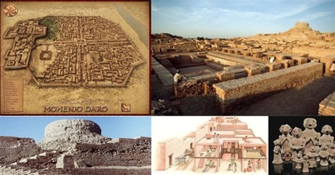
Mohenjo-Daro
Located in the Larkana district of Sindh (Pakistan), around 5 km from the Indus River, Mohenjo-Daro means “Mound of the Dead.” Discovered by Rakhaldas Banerji and later excavated by Sir John Marshall, it is the most iconic Harappan site.
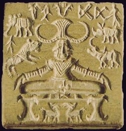
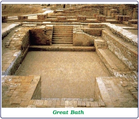
Famous structures include the Great Bath, a large granary, an assembly hall, and the Pashupati seal. The city had a well-planned layout with separate citadel and lower town areas. The lower town was home to various workshops, while the citadel possibly had symbolic or defensive significance. Evidence of repeated rebuilding points to its resilience against frequent floods.
Great Bath
A standout structure at Mohenjo-Daro, the Great Bath measures 14.5 × 7 meters and is 2.4 meters deep. Constructed with finely fitted bricks and bitumen for waterproofing, it had a drainage system sloping southwest and a well nearby. Likely used for ceremonial or religious bathing, it remains a marvel of ancient engineering.
Kalibangan
Situated on the dry bed of the Ghaggar River in Hanumangarh, Rajasthan, Kalibangan—meaning “black bangles”—had both early and mature Harappan phases. The city was divided into a fortified citadel and lower town.
Unique features include fire altars, used for rituals, and burial pits containing grave goods but no human remains—suggesting possible cremation practices. Its rich bangle-making industry is evident from terracotta, shell, alabaster, steatite, and faience bangles found in large numbers.
Kot-Diji
Located across the Indus River from Mohenjo-Daro, Kot-Diji was excavated by F.A. Khan. The site shows signs of both pre-Harappan and mature Harappan occupation.
Built from mud bricks and stone, Kot-Diji comprises a fortified citadel and a lower residential area. Discoveries include terracotta bulls, Mother Goddess figurines, and brick-lined ovens, with evidence of widespread burning.
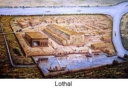
Lothal
Found between the Sabarmati and Bhogavo rivers in Gujarat, Lothal was excavated by S.R. Rao. Laid out in a rectangular plan, it had a fortified citadel and lower town.
Notable for its dockyard—one of the earliest in the world—Lothal was a major trading hub. Artifacts include 65 terracotta seals and fire altars. It is also one of the earliest sites to show evidence of rice cultivation.
Surkotda
Located in Kutch, Gujarat, and excavated by J.P. Joshi, Surkotda had a fortified citadel and lower town. A significant discovery was horse bones—rare in Harappan contexts—suggesting their presence in later phases. Burial practices resembling megalithic traditions were also noted.
Sutkagen-Dor
Near the Pakistan-Iran border, Sutkagen-Dor likely functioned as a trade seaport. Its citadel was fortified with stone walls, and the site is believed to have been cut off from the sea due to geological uplift.
Ropar
Located on the left bank of the Sutlej River in Punjab, Ropar was the first Harappan site excavated post-Partition. With a fortified citadel and lower town, Ropar revealed unique burial practices, including a dog buried beneath a human body. Artifacts include faience beads, terracotta cakes, and copper ornaments.
Alamgirpur
Situated on the Yamuna River in Uttar Pradesh’s Meerut district, Alamgirpur (also known as Parasaram-ka-Khera) featured burnt brick structures and fortifications, marking the easternmost Harappan site.
Amri
Located south of Mohenjo-Daro in Sindh, Pakistan, Amri has both pre-Harappan and mature Harappan layers but lacks extensive fortifications. Notably, remains of the rhinoceros were discovered here.
Chanhu-Daro
About 130 km south of Mohenjo-Daro, Chanhu-Daro was excavated by N.G. Majumdar and Earnest Mackay. Known as the “Sheffield of Ancient India,” it was a major craft center with no citadel. It revealed bead-making workshops, tools, and three cultural layers.
Banawali
Near the Rangoi River in Haryana, Banawali had evidence of all Harappan phases. Its fortified citadel and lower town featured brick-lined wells and drains. Excavations revealed a merchant’s house, seals, weights, and a terracotta plow, underscoring its role as a trade center.
Rakhigarhi
The largest Harappan site in India, located in Haryana, Rakhigarhi had fortified zones and a lower town. Noteworthy findings include lapidary workshops, bone and ivory tools, and a wooden coffin burial—unique to the region.
Rangpur
Near Vanala in Gujarat, Rangpur was excavated by M.S. Vats and showed evidence of rice cultivation. It served as a port city and had a fortified citadel.
Dholavira
Located on Kadir Island in the Rann of Kutch, Dholavira is unique with its tripartite layout—citadel, bailey, and middle town. Excavations revealed elaborate drainage systems, sandstone buildings, and advanced rainwater harvesting, not found in other Harappan cities. It was a crucial maritime trade hub with active craft production.
The Harappan Civilization, through its vast network of urban centers, exemplified advanced town planning, trade, craft specialization, and cultural diversity. These sites offer invaluable insights into one of the world’s earliest and most sophisticated urban civilizations.
Features of the Indus Valley Civilization
The Indus Valley Civilization (IVC), also known as the Harappan Civilization, stands out as one of the earliest and most sophisticated urban cultures of the ancient world. Spanning over a million square kilometres, it was the largest urban culture of its time and exhibited unique traits distinct from its Bronze Age contemporaries, such as Mesopotamia and Egypt.
Urban Revolution and Identity
Renowned archaeologist V. Gordon Childe described the cities of Harappa and Mohenjo-daro as symbols of an “Urban Revolution.” He emphasised that this transformation was gradual and rooted in socio-economic evolution rather than a sudden or violent shift. While the Indus civilization shared certain characteristics with other ancient civilizations, it maintained a distinctive identity. Unlike Egypt or Mesopotamia, there is no evidence of grand palaces, monumental temples, or elaborate tombs built for rulers. Instead, the civilization focused on functionality, uniformity, and civic order.
Administration and Political Organisation
The Indus Valley Civilization reflected a highly organized administrative system, evident through its meticulous urban planning and public infrastructure. The presence of massive public structures—such as the Great Bath, granaries, and systematically laid-out streets—indicates a centralized authority that coordinated civic activities efficiently.
Raised citadel areas at the heart of many cities suggest that important individuals, possibly local chiefs or governing councils, may have resided there. The sophistication of craft production, economic organisation, and social cohesion implies strong leadership and collective governance rather than rule by monarchs or dynasties.
Town Planning and Urban Infrastructure
Archaeologists Mortimer Wheeler and Stuart Piggott noted the remarkable uniformity in the design of Harappan towns. Cities were typically laid out in a grid pattern, with streets oriented north-south and east-west, demonstrating advanced urban planning principles that were unprecedented for the time.
Most cities were divided into two parts:
- Citadel (usually on the west): A raised, fortified area possibly used for administrative or ritual functions.
- Lower Town (usually on the east): Residential areas with houses, workshops, and markets.
Notable variations in city design include:
- Harappa, Mohenjo-daro, and Kalibangan: Featured distinct citadel and lower town areas.
- Lothal (Gujarat): Enclosed within a rectangular brick wall without an internal citadel-lower town division.
- Kalibangan: Used mud bricks; Harappa and Mohenjo-daro employed baked bricks. Some sites also used stone.
Standardization was a hallmark, seen in the consistent brick sizes and the alignment of streets and structures. Houses typically had multiple rooms arranged around a central courtyard, often with their own bathrooms, wells, and drains connected to a broader public drainage system.
The Great Bath
One of the most iconic public structures of the Indus Valley Civilization is the Great Bath at Mohenjo-daro, dating to around 2500 BCE. Believed to have been used for ritual bathing, it highlights the emphasis the civilization placed on cleanliness, hygiene, and possibly religious purification. The tank was built with watertight baked bricks and lined with gypsum mortar, with side rooms for changing and stairs leading into the water.
Granaries and Food Storage
Massive granaries were discovered at Harappa and Mohenjo-daro, indicating a centrally controlled food distribution system. These storage structures supported large-scale agricultural production and ensured food security.
- Harappa had six granaries, along with working floors likely used for threshing.
- Mohenjo-daro featured the largest known building, believed to be a granary.
The presence of such infrastructure points to advanced agricultural management and surplus storage.
Citadel: The Power Center
The citadel was a raised, fortified area that functioned as the administrative and possibly ritualistic core of the city. It housed major public structures like the Great Bath and granaries, reflecting organized civic planning and a centralized system of governance. The elevation of the citadel also provided protection against floods and symbolized authority within the settlement.
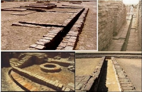
Drainage and Sanitation System
The drainage system of the Indus Valley cities was highly advanced and well-planned:
- Each house had access to its own courtyard, bathroom, and often a private well.
- Wastewater was channeled through covered street drains made of baked bricks.
- Manholes and inspection chambers were integrated for maintenance.
- In Kalibangan, many homes had independent wells, further showing attention to hygiene and water accessibility.
The Harappan emphasis on sanitation stands unmatched among Bronze Age civilizations, indicating a public consciousness about health, cleanliness, and environmental management.
The Indus Valley Civilization was not only the largest urban civilization of its time but also one of the most well-planned and systematically governed. With its advanced town planning, uniform architecture, sophisticated sanitation, and centralized administration, it laid the foundation for urbanism in South Asia. Despite the lack of monumental religious or royal structures, the civilization’s focus on civic order, hygiene, and community welfare speaks volumes about its priorities and societal values.
Funerary Customs
Three types of burial practices have been identified at Mohenjodaro:
- Complete Burials: Full body interment.
- Fractional Burials: Burial of collected bones post-exposure to natural elements.
- Part-Cremation Burials: Partial cremation before burial.
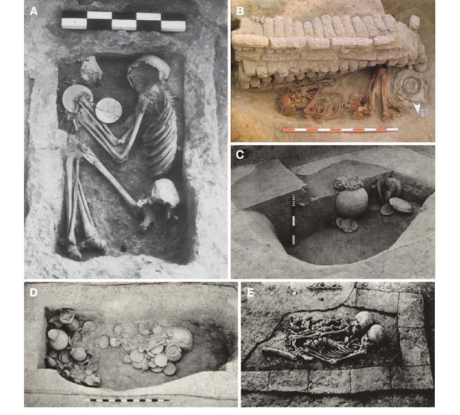
These diverse practices indicate a complex belief system regarding death and the afterlife.
Economic Life
The Harappan people enjoyed a prosperous lifestyle supported by surplus agriculture, animal husbandry, craft production, and extensive trade networks.
Agriculture
Agriculture formed the economic backbone of the Harappans. The fertile plains of Sindh supported the cultivation of wheat, barley, peas, kodon, sanwa, jowar, and ragi. They also grew dates, sesame, and mustard. At Lothal and Rangpur, rice husks and spikelets have been found, indicating rice consumption by 1800 BCE. Although sugarcane remains are absent, its cultivation is assumed. Notably, the Indus people were among the earliest cultivators of cotton—evidenced by a cotton fabric fragment at Mohenjodaro.
Water conservation was practiced through gabarbands or check dams, particularly in Baluchistan and Afghanistan. However, there is no evidence of canal irrigation.
Animal Husbandry
Animal rearing was common. The Harappans domesticated cattle, buffaloes (Bubalus bubalis), goats (Capra hircus), sheep, and pigs. Dogs and cats were kept as pets, and humped bulls were particularly valued. Camels and asses were used as pack animals, with camel bones found at Kalibangan. While evidence of horses is scarce, a possible equine fossil from Surkotada (c. 2000 BCE) suggests limited familiarity. Elephants, rhinoceroses, and deer were also known.
Trade and Commerce
Urban centers like Mohenjodaro, Harappa, and Lothal were hubs of metallurgy and trade. Lothal and Surkotada supplied cotton to Punjab. Balakot and Lothal exported seashells to Baluchistan and other Indus cities. Goods like dates and shilajeet were traded, showing a diverse commercial network.
Social Life
Social Hierarchy
Harappans practiced a simple yet structured social life. The family unit was matrilineal in some aspects, and women were held in high regard. Society was broadly divided into four occupational groups: scholars, warriors, traders, and laborers.
Food Habits
The Harappans were mostly non-vegetarian. Their diet included wheat, barley, bread, fish, beef, mutton, and poultry. Fruits like coconut, dates, pomegranate, lemon, and watermelon were commonly consumed.
Entertainment
Indoor recreation was preferred. Dance, music, dice games, chess, fishing, hunting, and swimming were popular. Children enjoyed marble dolls and animal figurines, indicating a rich cultural life.
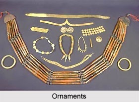
Costumes and Ornaments
Women wore short skirts held with bead girdles; men wore dhotis. There is no conclusive evidence of footwear use. Cotton was the primary textile—wool and linen were seemingly absent. Hairstyles varied, but long beards were uncommon. The famous ‘Dancing Girl’ has a ponytail, while men usually trimmed their beards or kept their faces shaven.
Both men and women adorned themselves with ornaments. Women wore fan-shaped headdresses and headbands. Decorative items were crafted from gold, silver, copper, and faience. Earrings were typically made of coiled metal. There is no evidence of nose ornaments.
Political Life
Harappan urbanization suggests an advanced socio-political structure. Cities operated as independent city-states governed by social discipline rather than military conquest. There is little evidence of warfare. Rulers appeared to focus on commerce, possibly a merchant class. The civilization may have had twin capitals—Harappa and Mohenjodaro—located approximately 350 miles apart, reflecting a decentralized but organized administrative framework.
The Harappan Script
The Harappans developed a system of writing, much like their contemporaries in ancient Mesopotamia. However, their script remains one of the greatest unsolved mysteries of ancient history.
Discovery and Nature of the Script
The first traces of the Harappan script were identified in 1853, but it wasn’t until 1923 that the full extent of the script began to emerge through archaeological discoveries. Despite decades of study, the script has not yet been deciphered.
Unlike alphabetical systems where each symbol represents a vowel or consonant, the Harappan script is believed to be pictographic in nature. It consists of approximately 375 to 400 distinct signs, each likely representing an idea, object, or sound rather than individual phonetic elements.
Direction and Style of Writing
The script was primarily written from right to left, as evidenced by the arrangement of signs on seals—wider spacing often appears on the right side, narrowing towards the left, suggesting the engraver began from the right. In some longer inscriptions, the boustrophedon method was used, where alternate lines were written in reverse directions (like the turning of an ox while ploughing a field).
Where the Script Appears
Harappan writing has been discovered on a variety of objects, including:
- Seals
- Copper tools
- Jar rims
- Terracotta and copper tablets
- Jewellery
- Bone rods
- Even an ancient signboard
Most inscriptions are brief, typically containing just a few symbols. The longest known inscription features only about 26 signs.
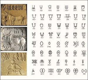
Uniqueness of the Harappan Script
What makes the Harappan script particularly intriguing is that it bears no relation to the writing systems of other contemporary civilizations like Mesopotamia or Egypt. Its unique structure and undeciphered nature continue to fascinate historians, archaeologists, and linguists worldwide.