TOne Academy

LAND DEGRADATION

Land Degradation:

      Soil or land degradation refers to the deterioration of soil quality resulting from inappropriate practices, often associated with agricultural, pastoral, industrial, or urban activities. This phenomenon includes various forms of degradation, such as physical erosion, chemical changes like salinity and alkalinity, and biological decline, which involves pollution and the degradation of plant cover.

Major Causes for Land Degradation:

Deforestation: 

    • The roots of trees and plants play a crucial role in anchoring soil particles and managing water flow, which helps protect the soil from erosion.
    • However, the rapid increase in population has intensified the demand for forest land and resources, leading to widespread deforestation.
    • The loss of forests renders the soil more susceptible to erosion, exacerbating the problem.
    • Significant soil degradation in regions such as the Shiwalik range, the Chos of Punjab, and the ravines of the Chambal valley can be attributed to deforestation.

Primary Factors Contributing to Deforestation:

Shifting Cultivation:

    • This agricultural method involves clearing a section of land, burning the vegetation, and incorporating the ash into the soil to enhance its nutrient content.
    • The land is cultivated for a period of two to three years, after which, if the yield diminishes, it is abandoned to allow for natural regeneration.
    • Subsequently, the same technique is applied to a new area. However, this practice has become increasingly unsustainable due to the escalating population pressures on forested regions.


Raw Materials:

    • Various industries utilize wood as a fundamental raw material for the production of items such as paper, plywood, furniture, matchsticks, boxes, crates, and packing cases.
    • Additionally, industries source raw materials from plants, including those used for pharmaceuticals, fragrances, resins, gums, waxes, turpentine, latex, rubber, tannins, alkaloids, and beeswax.


Additional Factors:

    • Mining activities, particularly open-pit mining, have led to widespread deforestation globally.
    • The surge in demand for commodities such as cocoa, coffee, tea, sugar, palm oil, and rubber has also contributed to deforestation in tropical rainforests.
    • Other contributors to deforestation include overgrazing, agricultural expansion, urban development, flooding, wildfires, pests, and diseases.


Consequences of Deforestation:

    • The reduction of closed forests, as determined by canopy coverage, has occurred due to deforestation, resulting in a rise in degraded forest areas, which transition from being carbon sinks to carbon sources.
    • Forests play a crucial role in recycling moisture from the soil into the surrounding atmosphere through the process of transpiration, which subsequently leads to precipitation in the form of rain.
    • The act of deforestation leads to an immediate decline in groundwater levels, primarily due to reduced percolation caused by rapid surface runoff on exposed land.
    • In the long term, this also contributes to a decrease in precipitation. Consequently, the natural cycle of water reuse is disrupted, leading to significant water loss through swift runoff.

Soil Salinity and Soil Alkalinity: 

    • Saline and alkaline soils exhibit a top layer that becomes saturated with saline and alkaline deposits, resulting in a surface covered with salt particles.
    • The weathering of undecomposed rock fragments leads to the formation of sodium, magnesium, and calcium salts, as well as sulfurous acid. Some of these salts are carried downstream in solution by rivers.
    • In areas characterized by a low water table, often due to excessive irrigation in canal-fed regions, salts can seep into the subsoil.
    • Conversely, in well-drained areas, these salts are washed away by flowing water. However, in regions with inadequate drainage, water with high salt concentrations can stagnate, leading to the accumulation of salts in the topsoil upon evaporation.
    • In locations where the subsoil water table is elevated, harmful salts are drawn upward through capillary action, particularly during the dry season when evaporation occurs.
    • Canal-irrigated regions typically have abundant water resources, which encourages farmers to over-irrigate their fields.
    • This practice raises the groundwater level, resulting in the emergence of saline and alkaline efflorescences, characterized by a white salt layer on the surface, composed of sodium, calcium, and magnesium salts.
    • Extensive areas of canal-irrigated land in Uttar Pradesh, Punjab, and Haryana, as well as arid regions in Rajasthan and semi-arid areas in Maharashtra, Gujarat, Andhra Pradesh, Telangana, and Karnataka, are grappling with this issue.
    • While the Indira Gandhi canal in Rajasthan has transformed the sandy desert into fertile land, it has also led to significant challenges related to salinity and alkalinity.

Impact of Salinity and Alkalinity: 

    • Salinity and alkalinity negatively influence soil health, leading to a decrease in soil fertility.
    • Cultivating crops on saline soils is unfeasible without extensive irrigation to wash away the accumulated salts.
    • The selection of crops is restricted to those that can withstand high salinity levels, such as cotton and barley.
    • The nutritional quality of both fodder and food produced in such conditions tends to be substandard.
    • Salinity and alkalinity pose challenges for construction projects, including buildings and roads.
    • They can also contribute to flooding by hindering water percolation.

Methods for Addressing Salinity and Alkalinity:

    • Establish drainage systems to facilitate the removal of excess water and reduce the water table.
    • Prevent water loss by sealing leaks in canals, reservoirs, and other water bodies through appropriate lining techniques.
    • Utilize irrigation resources efficiently to optimize water use.
    • Enhance plant cover by introducing salt-tolerant species to mitigate further land degradation.
    • Implement crop rotation practices to diversify soil use.
    • Apply gypsum generously to transform alkalis into soluble forms.
    • Remove alkali (base) by introducing sulfuric acid or other acid-generating materials such as sulfur and pyrite.
    • Incorporate organic materials like rice husks and rice straw to encourage the production of mild acids during decomposition.

Desertification: 

    • Desertification refers to the expansion of desert-like environments in arid or semi-arid regions, driven by human activities or climatic changes. A significant portion of the area between the Indus River and the Aravalli mountain range is experiencing the encroachment of desert conditions.
    • Soils in desert regions are particularly vulnerable to wind erosion. The wind transports sand, which settles on adjacent fertile lands, leading to a decline in their productivity.
    • Consequently, these fertile areas gradually blend into the encroaching desert. It has been estimated that the Thar Desert is advancing at a concerning rate of approximately 0.5 kilometers annually.
    • The phenomenon of desertification is primarily linked to overgrazing, indiscriminate deforestation, and an increasing population. Additionally, climate change has played a role in exacerbating the spread of desert areas.

Ecological Consequences of Desertification: 

    • The movement of sand and its buildup on farmland.
    • Significant soil erosion caused by both wind and water.
    • The accumulation of sand in rivers and lakes reduces their capacity to hold water.
    • A decline in the water table results in severe water scarcity.
    • An expansion of wasteland areas.
    • A reduction in agricultural output.
    • A rise in the frequency and severity of drought conditions.

Strategies for Mitigating Desertification: 

    • Implementing extensive tree planting initiatives in transitional areas.
    • Applying mulch made from various plant species to stabilize shifting sand dunes in arid regions, as mulches act as effective physical barriers against moving sand.
    • Regulating grazing practices and establishing new pasturelands.
    • Prohibiting the indiscriminate logging of trees.
    • Promoting alternative fuel sources to decrease reliance on firewood.
    • Utilizing sandy and degraded lands through careful and strategic planning.

Waterlogging:

    • The presence of flat terrains and depressions leads to the phenomenon of waterlogging. Soils that are waterlogged become saturated with water, which accumulates during the rainy season or results from leaks from various water sources.
    • In India, approximately 12 million hectares are affected by waterlogging, with half of this area located along the coastline and the other half situated inland.
    • Waterlogging is considered a significant contributor to soil salinity. The effective design of drainage systems is essential to mitigate the challenges posed by waterlogging.


The primary techniques for alleviating excess water in waterlogged soils include: 

    • Surface Drainage: This method entails the removal of surplus water from the ground surface via an open drainage system that has a suitable outlet.
    • Vertical Drainage: This refers to any borehole or well that extracts water from the underlying layers. It is particularly effective in the Indo-Gangetic plain, where the extracted water is utilized for irrigating adjacent areas.

Faulty Methods of Agriculture:

    • A significant portion of soil erosion in India can be attributed to ineffective agricultural practices. Improper ploughing techniques, insufficient crop rotation, and the implementation of shifting cultivation are among the most detrimental methods employed.
    • When fields are ploughed along the slope, there is no barrier to impede the flow of water, leading to the easy washing away of the topsoil.
    • In certain regions, the continuous cultivation of the same crop (monoculture) year after year disrupts the chemical equilibrium of the soil. This results in soil depletion, making it more susceptible to erosion by wind or water.
    • The clearing of forest cover associated with shifting cultivation exposes the soil to the elements, particularly rain and sunlight, which causes significant loss of topsoil, especially on sloped terrains.

Wind Erosion:

    • Wind erosion, also referred to as aeolian erosion, plays a crucial role in arid and semi-arid environments. In desert regions, high-speed winds prevail due to the lack of physical barriers. These winds effectively strip away fertile, loose soils, resulting in depressions that lack topsoil.
    • The creation of these depressions in desert landscapes is a preliminary stage in the development of an oasis. An oasis emerges in these low-lying areas when underground water accumulates above bedrock.
    • Fine and medium-sized sand particles are transported by the wind through a series of jumps and bounds, a process known as saltation.
    • Additionally, smaller sand and dust particles can be carried over extensive distances through the air via a mechanism called suspension.
    • Coarser sand typically does not become airborne; instead, it is rolled along the ground, a phenomenon referred to as surface creep.
    • Very coarse sand and gravel are too heavy to be lifted by the wind, resulting in wind-eroded soils that are characterized by surfaces covered with larger fragments. This type of arid soil surface is termed desert pavement.

Water Erosion: 

     Running water serves as a primary agent in the removal of soil particles. Water-induced soil erosion occurs through mechanisms such as raindrops, waves, or ice. The classification of water erosion varies based on its intensity and characteristics, including raindrop erosion, sheet erosion, rill and gully erosion, stream bank erosion, landslides, coastal erosion, and glacial erosion. 

Raindrop Erosion or Splash Erosion: 

    • A raindrop, measuring approximately 5 mm in diameter, impacts the soil at a speed of 32 km/h. Upon striking exposed soil, raindrops act like miniature explosives, displacing soil particles and compromising the soil’s structural integrity.
    • Vegetation plays a crucial role in mitigating raindrop impact by intercepting rainfall, thereby reducing soil erosion in vegetated areas.

Sheet Erosion: 

    • `thering and erosion work together to smooth out the irregularities of landforms, ultimately forming a peneplain.

Rill and Gully Erosion: 

    • Rill erosion is characterized by the formation of narrow, `d by the Grand Canyon along the Colorado River.

Coastal Erosion:

      Coastal regions experience significant soil degradation due to the relentless action of waves. The impact of cyclones, particularly during landfall, leads to storm surges that can devastate beaches and erode the uppermost soil layers. Additionally, tidal bores in estuarine environments inflict considerable damage on adjacent banks. 

Groyne for Coastal Protection: 

    • A groyne is a coastal defense structure constructed at a right angle to the shoreline (or riverbank) and extends over the beach to mitigate longshore drift and accumulate sediments.
    • This structure acts as a physical barrier, effectively intercepting the movement of sand along the coast.
    • Rock is frequently utilized as a building material; however, alternatives such as wooden groynes, steel groynes, rubble-mound groynes, sand-filled bag groynes, and concrete element groynes are also present.
    • Rock groynes are typically favored due to their enhanced durability and ability to absorb greater amounts of wave energy, attributed to their permeable characteristics.

Glacial erosion:

       It occurs in polar and high-altitude mountainous areas, such as the Himalayas, where soil erosion is driven by the gradual movement of glaciers.

Sea Erosion in India:

       As reported by the National Centre for Coastal Research (NCCR) in 2024, which operates under the Ministry of Earth Sciences, around 33.6% of India’s coastline is at risk of erosion, 26.9% is undergoing accretion, and 39.6% is considered stable.

Key findings of the Report:

    • Karnataka: Over the past thirty years, 48.4% of the 36.66 km coastline in Dakshina Kannada has undergone erosion.
    • West Bengal: Coastal erosion affects 60.5% of the coastline, with significant consequences for the Sundarbans region.
    • Kerala: Erosion threatens 46.4% of the coastline, posing risks to local communities and ecosystems.
    • Tamil Nadu: Erosion impacts 42.7% of the coastline, jeopardizing both infrastructure and the livelihoods of residents.

What accounts for the greater erosion observed on the Eastern Coast compared to the Western Coast? 

    • The Eastern Coast experiences more erosion primarily due to the rougher sea conditions and stronger tidal movements in the Bay of Bengal, in contrast to the calmer Arabian Sea.
    • Additionally, the Eastern Coast has been subjected to more frequent cyclonic events originating from the Bay of Bengal over the past thirty years, while the Western Coast has remained relatively stable.
    • In addition to the southwest monsoon season (June to September), the Eastern Coast is also affected by the Northeast Monsoon from October to December, which brings rainfall to coastal regions such as Andhra Pradesh and Tamil Nadu, contributing to rough sea conditions for a significant portion of the year.


Beyond natural factors, certain human activities have exacerbated erosion, including: 

    • Coastal construction, such as the development of ports.
    • Dredging activities in port areas and the disposal of dredged sediments into deep waters, which ideally should be placed along the coastline.


Approximately 28.7% of Andhra Pradesh’s coastline is experiencing varying levels of erosion, with around 28 kilometers of the coastline in Visakhapatnam—recently designated as the capital of Andhra Pradesh—being particularly vulnerable. The erosion of beaches in this area has been ongoing since the establishment of Visakhapatnam Port in the 1930s.

Erosion and Accretion:

    • Coastlines are ever-changing landforms that continuously experience processes of erosion and accretion.
    • These coastal areas are influenced by various factors, including wind, wave action, tidal movements, ocean currents, geological features, sediment availability, and human activities.
    • Accretion is defined as the growth of a coastal region, characterized by an increase in either the width or length of the shoreline.
    • While accretion is not typically viewed as destructive in the same manner as erosion, it can adversely affect deltaic ecosystems by diminishing the inland flow of water.

Strategies for Mitigating Coastal Erosion:

    • Beaches are inherently dynamic environments and should be regarded as integral components of the marine ecosystem rather than merely extensions of terrestrial land.
    • Serving as buffers, beaches absorb the impact of powerful wave action from the sea, protecting the adjacent landmass. It is essential to continuously nourish these beaches through natural processes; any disruption can lead to significant erosion, potentially resulting in detrimental effects on the land, such as the collapse of roadways.
    • The construction of a submerged breakwater approximately 500 meters offshore can dissipate wave energy and mitigate erosion caused by wave currents. Additional protective structures, including sea walls, revetments, and groynes, can also contribute to erosion control.
    • Beach Nourishment: This approach involves the extraction of sand from the ocean and its redistribution onto eroding beaches. The objective is to artificially expand the beach area by increasing the sediment supply on beaches that are experiencing a deficit.

National Centre for Coastal Research (NCCR): 

    • This organization operates as a subsidiary of the Ministry of Earth Sciences.
    • Its primary function is to observe and assess changes occurring along the Indian coastline.

National Centre for Sustainable Coastal Management (NCSCM): 

    • NCSCM serves as a research institution under the auspices of the Ministry of Environment, Forest and Climate Change (MoEF&CC).
    • Its mandate is to ensure the sustainable management of the Indian coastal regions.

Desertification Setting in Across a Quarter Of India:

    • The report titled “Desertification and Land Degradation of Selected Districts of India,” released by ISRO, indicates that approximately 96.40 million hectares, which constitutes around 30 percent of India’s total land area, is experiencing degradation.
    • Furthermore, drylands cover 228.3 million hectares, accounting for 70% of the nation’s land. Out of these drylands, 82.6 million hectares, or roughly 25% of the overall land area, is affected by desertification.

Regional Factors Contributing to Desertification and Land Degradation:

    • Maharashtra: The activities of the timber mafia are depleting already limited forest resources, resulting in soil erosion.
    • Jharkhand and Odisha: Intensive mining operations have caused soil erosion and worsened water shortages.
    • Goa: Uncontrolled mining and urban expansion have adversely affected the environment.
    • Nagaland: The practice of shifting cultivation (jhum cultivation) combined with a growing population is contributing to desertification.
    • Andhra Pradesh, Telangana, and Hyderabad Karnataka: Prolonged droughts and an increased reliance on borewells have resulted in soil dryness.
    • Himachal Pradesh: A reduction in snowfall coupled with increased rainfall has exacerbated the desertification issue.
    • Gujarat: Overgrazing and the conversion of grasslands for agricultural purposes are significant factors in land degradation.

Deforestation due to illegal mining:

    • Illegal mining activities have resulted in significant deforestation in Goa, as highlighted by the 2018 Land Degradation and Desertification Atlas published by ISRO.
    • The demand for iron ore during the construction boom for the 2008 Olympics in China caused extensive damage to forested areas.
    • In response to the widespread illegal mining practices, the Supreme Court intervened in 2012, halting mining operations in Goa.

Apathy towards Environmental Governance: 

    • According to the Forest Survey of India’s 2017 State of Forest Report, a significant portion of Goa’s forests lies outside the officially designated forest areas.
    • The total forest cover in the state is estimated at 2,229 square kilometers, representing 60.21 percent of the state’s land.
    • However, the state forest department’s records indicate only 1,224.46 square kilometers as government-managed forest.
    • For instance, in Mopa, where the Goa government plans to construct an airport, the Environmental Impact Assessment (EIA) initially reported no tree cover.
    • Yet, during subsequent legal proceedings, the forest department identified 54,676 trees in the area!

Desertification in Cold Regions: 

    • High-altitude areas characterized by minimal rainfall are referred to as cold deserts. Approximately 80 percent of India’s cold desert region is located in the union territory of Ladakh, with the remainder found in Himachal Pradesh and Uttarakhand.
    • There is substantial evidence indicating an increase in desertification within the trans-Himalayan regions, manifested through shifting tree lines, migrating sand dunes, and alterations in soil moisture levels.


The area of grasslands has diminished by 31%, equating to a loss of 12.3 million hectares, from a total of 18 million hectares between 2005 and 2015.

    Notably, the grasslands in the Aravalli range of Rajasthan have experienced significant degradation. During the same timeframe, approximately 19% of common lands were lost, decreasing from 90.5 million hectares to 73.02 million hectares.

    Common lands encompass grazing areas, certain forested regions, ponds, rivers, and other spaces accessible to all members of rural communities.

According to the State of India’s Environment (SoE) Report 2019:

    • This report says, desertification has escalated in 26 out of 29 states from 2003-05 to 2011-13.
    • Although India pledged to achieve land degradation neutrality by 2030, the country saw an increase of 1.87 million hectares affected by desertification during this period.
    • Over 80% of the degraded land is concentrated in nine states: Rajasthan, Maharashtra, Gujarat, Jammu and Kashmir, Karnataka, Jharkhand, Odisha, Madhya Pradesh, and Telangana.
    • The districts most severely impacted by desertification or land degradation include Jaisalmer (93%), Lahaul and Spiti (80%), and Kargil (78%).

Addressing Land Degradation and Desertification:

   SDG 15: Life on Land: “encourage the sustainable utilization of terrestrial ecosystems, effectively manage forest resources, combat desertification, and prevent and reverse land degradation while also halting the loss of biodiversity.” In recent decades, the rate of desertification has increased by 30 to 35 times compared to historical averages. Over the past twenty years, at least 25% of the world’s land has experienced degradation. Approximately 1.5 billion individuals rely on this deteriorating land for their livelihoods.

Soil Conservation:

      The prosperity of humanity is closely linked to the health of the soil; its degradation leads to decline. Ignoring soil health is akin to destroying the source of wealth. Soil conservation involves safeguarding the soil from erosion and maintaining its fertility, which can be compromised by overexploitation, acidification, salinization, or other forms of chemical contamination. 
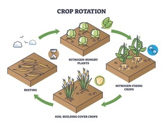
Crop Rotation: 

    • Implementing sustainable agricultural methods is crucial for effective soil conservation. In various regions of India, the same crop is often planted in the same field annually, resulting in the depletion of specific nutrients and rendering the soil infertile.
    • Crop rotation is a technique that entails growing different crops on the same land in successive years. This practice aids in preserving soil fertility, as distinct crops have varying nutrient requirements. Crop rotation allows for the replenishment of depleted nutrients.
    • For instance, potatoes have a high demand for potash, while wheat requires nitrates. Therefore, alternating these crops is advantageous.
      Additionally, legumes such as peas and beans enrich the soil by converting atmospheric nitrogen into nitrogenous nodules on their roots. Incorporating these plants into the crop rotation can reduce the need for nitrogenous fertilizers.


Utilization of Early Maturing Varieties: Early maturing crop varieties require a shorter growth period, thereby exerting less strain on the soil. This characteristic contributes to the mitigation of soil erosion. 

Strip Cropping: 

    • Crops can be planted in alternating strips that run parallel to each other. Certain strips may be left fallow while others are cultivated with various crops.
    • This practice allows for the harvesting of different crops at staggered times, ensuring that the land is not left bare or exposed at any point throughout the year.
    • Taller crops serve as windbreaks, and the parallel arrangement of strips, often aligned with the land’s contours, enhances soil water absorption by reducing runoff.
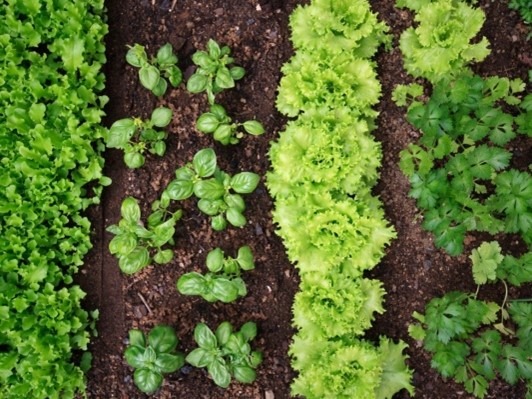


Inter Cropping:

    • In this method, diverse crops are planted in alternating rows and sown at different times, providing protection to the soil against erosion caused by rainfall.


Contour Ploughing: 

    • When ploughing is conducted at right angles to the slope of a hill, the resulting ridges and furrows disrupt the downward flow of water. This practice helps to minimize soil erosion by reducing the likelihood of gully formation and decreasing runoff, thereby allowing plants to access more water.
    • Additionally, ploughing in a direction that is perpendicular to prevailing winds diminishes wind speed, thereby safeguarding the topsoil from erosion.


Mitigating Shifting Cultivation:

    • An effective strategy for soil conservation involves curbing shifting cultivation by encouraging indigenous communities to transition to settled agriculture. This can be achieved through resettlement planning, which includes providing housing, agricultural tools, seeds, fertilizers, livestock, and rehabilitated land. 

Mulching:

    • A protective layer of organic material, such as grass clippings or straw, is applied to the bare soil (topsoil) between plants to shield it from erosion.

Advantages: 

    • Shields the soil against erosion.
    • Mitigates compaction caused by heavy rainfall.
    • Preserves moisture, leading to less frequent irrigation.
    • Regulates soil temperature more consistently.
    • Deters the growth of weeds.
    • Organic mulches enhance soil quality. As these materials gradually break down, they contribute organic matter that aids in maintaining soil aeration.

Contour barriers: 

    • Barriers constructed along the contours of the land utilize materials such as stones, grass, and soil. Trenches are excavated in front of these barriers to capture water, effectively intercepting the flow of water and soil particles moving downhill.
    • This design slows the movement of water and diminishes its erosive impact. Additionally, these barriers serve to filter and retain many suspended soil particles, preventing them from being washed away from the field.
    • One significant long-term benefit of these barriers is the accumulation of soil behind them, which results in a terraced landscape.
    • Barriers can be categorized into three types: live barriers, consisting of strips of living vegetation; dead barriers, made from rocks or crop residues; and mixed barriers, which combine elements of both live and dead materials.

Rock Dam:

    • A rock dam consists of stones arranged across a water channel to diminish the velocity of the water flow. This technique helps to mitigate the formation of gullies and curtails soil erosion. 

Terrace Farming:

    • Terrace farming involves the creation of multiple flat surfaces along a hillside by cutting terraces into steep slopes. This method provides suitable areas for crop cultivation and effectively reduces surface runoff and soil erosion. 
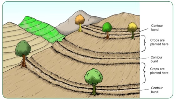
Contour Bunding:

    • Contour bunding entails the establishment of embankments that follow the natural contours of the land. Both terracing and contour bunding segment the hillside into smaller sections, regulate water flow, enhance soil water absorption, and protect against soil erosion. The retaining walls of terraces play a crucial role in managing water flow and further minimizing soil erosion. 

Shelterbelts or Windbreaks:

    • In coastal and arid areas, rows of trees are strategically planted to mitigate wind movement, thereby safeguarding soil cover. 

Sand Fences:

    • Sand fences consist of barriers constructed from small, uniformly spaced wooden slats or fabric. These structures are designed to diminish wind speed and capture drifting sand. Additionally, sand fences can serve as perimeter controls around open construction sites, preventing sediments from being displaced by wind. 

Afforestation:

    • This process encompasses both the prevention of deforestation and the establishment of new forests or the expansion of existing forested areas. A minimum of 20 to 25 percent of land designated for forests is deemed essential for effective soil and water conservation across the nation. This requirement was increased to 33 percent during the second five-year plan, with allocations of 20 percent for flatlands and 60 percent for hilly and mountainous regions.

Monitoring Overgrazing: 

    • Overgrazing significantly contributes to soil erosion. During dry seasons, the availability of fodder diminishes, leading to animals grazing grass down to the roots.
    • The hooves of these animals further pulverize the soil, resulting in a weakened topsoil layer. Therefore, it is essential to manage overgrazing to mitigate soil erosion.
    • This can be achieved by establishing designated grazing areas and increasing the production of fodder.

Dams: 

    • The construction of dams at strategic locations can greatly reduce soil erosion caused by river flooding. Dams help to slow down water flow, thereby protecting the soil from erosion.
    • However, indiscriminate dam construction may exacerbate the situation, leading to floods and landslides, as observed in the Himalayan region.

Geotextiles: 

    • Geotextiles are permeable fabrics, either synthetic or natural, that are utilized in conjunction with soil to enhance its stability and protection.
    • They are commonly employed to improve the soil beneath roads, embankments, and soil-retaining structures.
    • Synthetic geotextiles are generally composed of polypropylene or polyester, while natural geotextiles are made from materials such as jute and coconut coir.
    • In 2020, the Government of India permitted the use of coconut coir-based geotextiles for the construction of rural roads under the Pradhan Mantri Gram Sadak Yojana.

United Nations Convention to Combat Desertification (UNCCD):

    • The UNCCD, alongside the Convention on Biological Diversity (CBD) and the United Nations Framework Convention on Climate Change (UNFCCC), was established during the Earth Summit held in Rio de Janeiro in 1992.
    • The Convention was formally adopted in Paris in 1994 and has since been ratified by 196 nations and the European Union. India became a signatory to the UNCCD in 1996.
    • The UNCCD serves as a framework for promoting global efforts to combat land degradation. It stands as the sole legally binding international treaty that connects environmental issues with development, emphasizing sustainable land management practices.
    • The Convention mandates that participating countries develop their national action programs (NAP) through a grassroots approach, focusing on community involvement to rehabilitate degraded lands.
    • To facilitate the implementation of the Convention, the Global Mechanism (GM) was created under the UNCCD to support countries in securing financial resources.


The Conference of the Parties (CoP) of the UNCCD serves as the highest decision-making authority within the framework of the Convention. This assembly convenes biennially to assess the progress of the Convention’s implementation, develop strategic initiatives, and coordinate efforts with various organizations and non-governmental entities.

Recent sessions of the CoP under the UNCCD include:

    • COP 13 – 2017, held in Ordos City, China
    • COP 14 – 2019, hosted in New Delhi, India
    • COP 15 – 2022, conducted in Abidjan, Côte d’Ivoire
    • COP 16- 2024, The sixteenth session of the Conference of the Parties (COP16) to the United Nations Convention to Combat Desertification (UNCCD) is scheduled to occur in Riyadh, Saudi Arabia, from December 2 to December 13, 2024. This conference seeks to enhance efforts towards land and drought resilience by adopting a people-centered strategy.


Looking ahead, the upcoming biennial meetings of the Conference of the Parties and its subsidiary bodies are scheduled to take place in Mongolia (COP 17 in 2026).

CoP-14 in New Delhi:

    • During CoP-14, India was appointed as the president, serving until CoP 2015.
    • The theme for CoP-14 was “Restore land, sustain future.”
    • Only 25% of countries incorporate gender considerations into their land degradation objectives.
    • The UNCCD emphasizes the importance of integrating gender perspectives to support nations in achieving their Land Degradation Neutrality (LDN) goals.
    • Incorporating gender considerations not only promotes gender equality but also enhances women’s access to and control over land and natural resources, alleviates poverty, and aids in ecosystem restoration, among other benefits.

Report on Soil Organic Carbon:

       Soil Organic Carbon (SOC) plays a crucial role in delivering a range of benefits. It helps mitigate drought, decreases soil diseases and compaction, and supports organic farming. Due to its diverse functions and sensitivity to land management practices, SOC is recognized as one of the three global indicators of Land Degradation Neutrality (LDN). 

CoP-15 in Abidjan: 

        The theme for CoP-15, “Land. Life. Legacy: From scarcity to prosperity,” serves as a call to action to ensure that land, a vital resource for life on Earth, continues to provide benefits for both current and future generations. The goal is to restore one billion hectares of degraded land by 2030. 

The three main declarations from CoP-15 included: 

    • The Abidjan Call, issued by Heads of State and Government, aimed at enhancing long-term sustainability.
    • The Abidjan Declaration, which focuses on achieving gender equality as a critical component of effective land restoration.
    • The COP-15 “Land, Life & Legacy” Declaration, which responds to insights from the UNCCD’s flagship report, Global Land Outlook 2 (the second edition of the GLO).


The Global Land Outlook (GLO) is a publication by the UNCCD that highlights challenges within land systems and presents transformative policies that offer cost-effective strategies for scaling up sustainable land and water management.

CoP-16 in Riyadh:

Key Outcomes of COP16 UNCCD (2024):

    • Global Drought Framework: Significant advancements have been made in the development of a global drought framework, which is expected to be finalized by COP17 in Mongolia in 2026.
    • Financial Commitments: A total of over USD 12 billion has been pledged worldwide to address issues related to desertification, land degradation, and drought.
    • The Riyadh Global Drought Resilience Partnership has allocated USD 12.15 billion to support 80 at-risk countries, with USD 10 billion sourced from the Arab Coordination Group.
    • Great Green Wall (GGW) Initiative: Italy has contributed Euros 11 million towards the restoration of landscapes in the Sahel region.
    • Austria has provided Euros 3.6 million to improve coordination among 22 African nations participating in the GGW initiative.
    • Vision for Adapted Crops and Soils (VACS): Nearly USD 70 million has been pledged to foster climate-resilient food systems through the cultivation of diverse, adapted crops in healthy soils.
    • Indigenous Representation: Caucuses have been established for Indigenous Peoples and Local Communities to ensure their participation in land and drought governance.
    • The Sacred Lands Declaration was presented at the Indigenous Peoples Forum to promote global engagement in governance matters.
    • Business4Land Initiative: There is a strong focus on the role of the private sector in addressing Desertification, Land Degradation, and Drought (DLDD).
    • Currently, the private sector contributes only 6% of the funding required for land restoration and drought resilience.
    • Science-Policy Interface (SPI): The UNCCD SPI continues to function, facilitating the translation of scientific research into practical recommendations for policymakers, a framework established at COP11 in Windhoek in 2013.

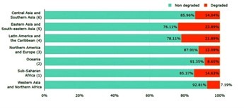
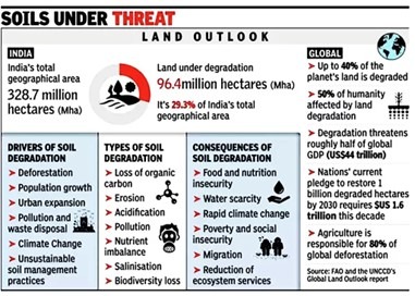
Major Concerns: Current status of Land Degradation and Desertification:

        Forty percent of the Earth’s land is currently degraded, posing a direct risk to half of the global population and threatening approximately 50 percent of the world’s GDP, equating to around $44 trillion. Progress towards the restoration of one billion hectares of degraded land by 2030 is occurring at a sluggish pace.


Global Drying Trends:

    • According to the UNCCD report titled The Global Threat of Drying Lands, 77.6% of the Earth’s land has experienced increased aridity since the 1990s.
    • Currently, drylands account for 40.6% of the Earth’s terrestrial area (excluding Antarctica), indicating a significant reduction in productive land.


Key Regions Affected:

    • Europe: A staggering 95.9% of its land exhibits marked drying trends.
    • Brazil: Certain areas in Brazil are experiencing severe drying conditions.
    • Western United States: The region is showing a rise in arid conditions.
    • Asia and Central Africa: These areas are experiencing significant drying trends, accompanied by ecosystem degradation and desertification.
    • Africa and Asia: Both continents are facing biodiversity loss due to deteriorating ecosystems and the spread of desertification.


Projected Impact:

    • By the century’s end, in a worst-case scenario, as many as 5 billion individuals may inhabit drylands.
    • These regions are expected to encounter severe challenges, including water shortages, soil degradation, and the collapse of ecosystems.


UNCCD Work and Impact: 

    • The UNCCD advocates for strategies that prevent, mitigate, and reverse land degradation.
    • As of now, only 18 percent of the Great Green Wall’s targets for 2030 have been met. Key obstacles hindering the Great Green Wall (GGW) include insufficient communication, funding, and coordination.
    • In China, communities have significantly contributed to combating desertification, with approximately 25 percent of its land classified as desert. The country has emerged as a global frontrunner in desert greening due to effective community involvement.
    • The GGW initiative aims to rehabilitate 100 million hectares of degraded land, sequester 250 million tons of carbon, and generate 10 million green jobs by the year 2030.


The Great Green Wall Initiative: 

    • Initiated in 2007 by the African Union, this ambitious project spans 22 African nations and seeks to rejuvenate thousands of communities throughout the continent.
    • The Sahel region, characterized as semiarid, serves as a transitional area between the Sahara Desert to the north and the tropical savannas to the south.
    • This region encompasses the fertile delta of the Niger River, yet its arable land is swiftly transforming into desert due to factors such as drought, deforestation, and intensive agricultural practices.
    • The initiative is a key driver of Sustainable Development Goal 15 and aims for Land Degradation Neutrality (LDN).
    • The Drought Initiative encourages a proactive approach to drought management.
    • The Great Green Wall Initiative focuses on restoring Africa’s degraded landscapes within the Sahel region.

UNCCD Global Land Outlook Report:

Decline of Agricultural Land Due to Urban Expansion: 

    • Historically, human settlements have emerged in areas characterized by fertile and easily accessible land. However, the expansion of these urban areas is increasingly encroaching upon valuable agricultural land.
    • It is estimated that urbanization will result in the loss of approximately 1.6 to 3.3 million hectares of high-quality agricultural land annually from 2000 to 2030, totaling between 48 and 99 million hectares over this period.
    • This reduction in cropland is expected to lead to a 6 percent decrease in agricultural production in Asia and a 9 percent decline in Africa.
    • The rising global demand for meat has intensified pressure on land resources.
    • A reduction in average meat consumption from 100 grams to 90 grams per person per day could have a substantial positive effect on both public health and climate change mitigation.
    • The increasing appetite for meat and other land-intensive foods, such as processed products containing soy and palm oil, has contributed to challenges such as land scarcity and food insecurity.

 Water Scarcity: 

    • It is anticipated that by 2030, the demand for water will exceed the capacity for extraction by 40 percent.
    • By 2025, approximately two-thirds of the global population is expected to reside in countries experiencing water stress.
    • The requirement for water in agriculture is projected to double by 2050, driven by the increasing need for food production.


The following crops are identified as the most water-intensive, measured in liters per kilogram of production: 

    • Cotton (7,000 to 29,000 liters/kg),
    • Rice (3,000 to 5,000 liters/kg),
    • Sugar cane (1,500 to 3,000 liters/kg),
    • Soya (2,000 liters/kg), and
    • Wheat (900 liters/kg).


Currently, two billion individuals and 40 percent of irrigation practices rely on groundwater sources. The countries with the highest groundwater usage include India (39 million hectares), China (19 million hectares), and the United States (17 million hectares).

Drought: 

    • A significant relationship exists between land use and drought, necessitating an integrated approach to the management of both land and drought conditions.
    • Drought is identified as one of the five ‘Strategic Objectives’ of the UNCCD for the period from 2018 to 2030. The UNCCD has introduced the notion of ‘drought-smart land management’ (D-SLM) as part of a broader framework of sustainable land management (SLM) interventions.

Cost:

    • An investment of $1.8 trillion in climate adaptation strategies over the next ten years is expected to yield substantial on-the-ground transformations. 

Desertification from a Conservation Perspective:

    • Desertification does not refer to the natural spread of existing deserts globally. Instead, it denotes the degradation of land in arid, semi-arid, and dry sub-humid regions. This process results in a gradual decline in soil productivity, rendering the cultivation of food grains and other crops unfeasible.

Significance of Addressing Land Degradation:

    • Approximately 34% of the Earth’s terrestrial surface and 50% of agricultural lands are classified as drylands. These regions support over 2 billion individuals and sustain half of the global livestock population.

Land Degradation Neutrality (LDN) Initiative: 

    • The LDN concept was introduced during the UN Conference on Sustainable Development (Rio+20) in 2012.
    • In 2015, LDN was established as a target under Sustainable Development Goal 15, which focuses on the preservation of terrestrial ecosystems.
    • At the 12th Conference of the Parties (COP12) to the United Nations Convention to Combat Desertification (UNCCD), member states recognized LDN as a crucial mechanism for advancing the implementation of the UNCCD and urged nations to establish voluntary targets aimed at achieving “no net loss” by the year 2030.
    • In the New Delhi Declaration, over 190 countries committed to attaining ‘land degradation neutrality’ by 2030, while ensuring that these initiatives do not infringe upon the land rights of forest-dependent communities and women. However, these nations will need to mobilize approximately $300 billion to enhance restoration efforts.
    • India’s LDN Goals: India aims to rehabilitate 26 million hectares of degraded land by 2030, an increase from the previous target of 21 million hectares.