Atmospheric Circulation and Weather Systems
Atmospheric Pressure
Atmospheric pressure refers to the force exerted by the weight of a column of air extending from the surface of the Earth to the top of the atmosphere, measured over a unit area. It is essentially the pressure exerted by the air above a particular point on the Earth’s surface. Atmospheric pressure plays a critical role in determining weather patterns, wind systems, and precipitation processes, making it one of the core parameters studied in climatology and meteorology.
The atmospheric pressure at mean sea level is approximately 1034 grams per square centimetre, which translates to a standard pressure of 1013.25 millibars (mb) or 1 atmosphere (atm). In the SI system, this is equivalent to 101325 Pascals (Pa) or 101.325 kilopascals (kPa). Meteorologists primarily use millibars (mb) and pascals (Pa) as the standard units of measurement.
1 atm = 1013.25 mb = 101325 Pa = 101.325 kPa
Formation of Pressure Cells: Low and High Pressure
Atmospheric pressure is not uniform across the globe. It varies based on several factors such as temperature, altitude, air composition, and topography. When a parcel of air is heated, it expands and becomes less dense, leading to a drop in pressure. This results in the formation of a low-pressure cell or a low-pressure centre. On the other hand, when air is cooled, it contracts and becomes denser, causing a rise in pressure and forming a high-pressure cell or high-pressure centre.
These cells are fundamental in the creation of global pressure systems such as cyclones (low-pressure systems) and anticyclones (high-pressure systems). Their interaction determines wind patterns, precipitation, and the overall circulation of the atmosphere.
Influence of Land and Sea on Pressure Systems
The distribution of continents and oceans significantly influences atmospheric pressure patterns. During winter, continents cool faster than oceans due to their lower specific heat, leading to the formation of high-pressure centres over land. Conversely, in summer, landmasses heat up more rapidly and develop low-pressure systems. Oceans, being more thermally stable, exhibit the opposite pattern—lower pressure in winter and higher pressure in summer. This seasonal variation contributes to phenomena like the monsoon winds, which are driven by differential heating between land and sea.
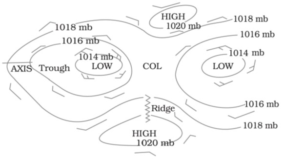
Understanding Isobars and Pressure Gradient
Isobars are lines drawn on weather maps that connect points of equal atmospheric pressure. They are instrumental in studying the spatial distribution of pressure and predicting wind movement and storm development. The spacing of isobars reflects the rate of pressure change, known as the pressure gradient.
- When isobars are closely spaced, the pressure gradient is steep, indicating strong winds and potentially turbulent weather.
- When isobars are widely spaced, the gradient is gentle, suggesting calm or stable atmospheric conditions.
Closed isobars, or closed pressure centres, are circular or oval patterns indicating pressure systems. A low-pressure system is enclosed by isobars with the lowest pressure at the centre, commonly associated with cloud formation and precipitation. In contrast, a high-pressure system has isobars enclosing the highest central pressure, often linked with clear skies and dry weather.
Distribution of Atmospheric Pressure: Vertical and Horizontal
- The distribution of air pressure on Earth is not uniform and shows variations in both the vertical and horizontal dimensions.
Vertical Distribution
As we move upward in the atmosphere, pressure decreases with increasing altitude. This decline is not uniform, due to differences in temperature, moisture content, and gravitational influence at different altitudes. The lower layers of the atmosphere are denser and exert more pressure. The vertical pressure gradient force—which drives air movement upwards—is much stronger than the horizontal gradient, although it is usually balanced by the downward gravitational force. A rising barometric pressure generally indicates clear and stable weather, while falling pressure suggests the approach of unstable, cloudy, or stormy conditions.
Horizontal Distribution
Horizontal variations in pressure are studied by drawing isobars. The rate of pressure change across horizontal distances is influenced by latitude, proximity to oceans, and surface temperature. These horizontal variations give rise to major pressure belts—such as the Equatorial Low, Subtropical High, Subpolar Low, and Polar High—that govern global wind systems like the trade winds, westerlies, and polar easterlies.
Wind Movement
Wind refers to the horizontal movement of air across the Earth’s surface, driven by differences in atmospheric pressure. In contrast, air currents represent the vertical movement of air. The movement of wind is not random but governed by a combination of dynamic and thermodynamic forces. These forces determine the speed, direction, and nature of wind systems at various altitudes and geographic locations.
Primary Forces Influencing Wind Movement
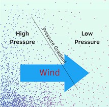
1. Pressure Gradient Force (PGF)
The pressure gradient force arises due to the difference in atmospheric pressure between two areas. Air naturally moves from a region of higher pressure to a region of lower pressure, creating wind. The greater the pressure difference, the stronger the force and, consequently, the higher the wind speed.
- The pressure gradient is stronger where isobars (lines of equal pressure) are closely spaced, and weaker where they are widely spaced.
- Wind direction under the sole influence of pressure gradient force would move perpendicular to isobars, from high to low pressure.
- Even small pressure differences can generate significant wind systems and influence their direction and velocity.
2. Buoyant Force and Atmospheric Stability
Buoyant force governs the vertical movement of air. It arises when a parcel of air is either warmer and lighter or cooler and heavier than the surrounding air.
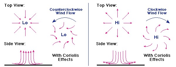
- In a low-pressure cell, the air is less dense and hence rises due to the upward buoyant force. This process is associated with air convergence at the surface and leads to unstable weather conditions, often resulting in cyclones, cloud formation, and precipitation.
- Conversely, in a high-pressure cell, the air is denser and tends to sink due to its weight. This subsidence of air leads to divergence at the surface, promoting stable and clear weather conditions, typical of anticyclones.
- The vertical wind circulation in the upper troposphere tends to mirror and oppose the surface-level wind movement.
- Other mechanisms that cause air to rise and contribute to cloud development include:
- Convection currents (due to surface heating),
- Orographic uplift (air forced to rise over mountains),
- Frontal uplift (air lifted along weather fronts).
3. Frictional Force
Frictional force acts as a resisting force against wind movement, caused by the irregularities of the Earth’s surface, such as mountains, forests, and urban landscapes.
- At or near the Earth’s surface, friction significantly reduces wind speed and causes the wind to deviate from the path dictated by the pressure gradient.
- Winds close to the ground tend to cross isobars at higher angles compared to those at higher altitudes.
- The effect of friction is most pronounced up to 1–3 km above the Earth’s surface. Beyond this, the influence decreases, and wind patterns become more geostrophic.
- Over ocean surfaces, friction is minimal, allowing winds to maintain higher speeds and smoother flow patterns.
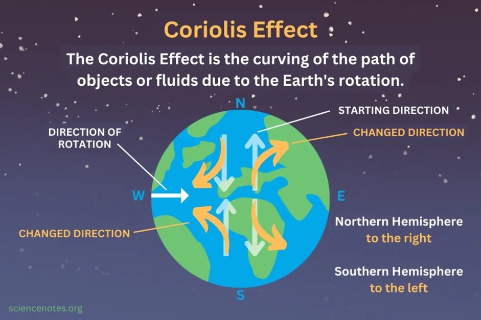
4. Coriolis Force (Effect of Earth’s Rotation)
Due to the rotation of the Earth, moving air is deflected from its path—a phenomenon known as the Coriolis force or Coriolis effect.
- In the Northern Hemisphere, this deflection is to the right of the motion path.
- In the Southern Hemisphere, the deflection is to the left.
- This force was formally described by Farrell’s Law and only acts when an object is already in motion.
- The magnitude of Coriolis force depends on three factors:
- The velocity of the moving object,
- The angular velocity of Earth’s rotation (ω),
- The latitude (ϕ).
The force is mathematically represented as:
Coriolis Force (Fc) = 2νω sinϕ
Where:
- ν = velocity of the object,
- ω = angular velocity of the Earth,
- ϕ = latitude.
- At the equator (ϕ = 0°), the Coriolis force is zero.
- At the poles (ϕ = 90°), the force reaches its maximum.
The Coriolis force influences a wide range of phenomena including the deflection of wind systems, ocean currents, long-distance projectiles, and aircraft trajectories.
5. Centripetal Acceleration (Curved Wind Flow Around Pressure Centres)
Centripetal acceleration comes into play when air flows in a curved path around pressure centres, such as in cyclones and anticyclones.
- This force acts perpendicularly to the direction of wind movement and inward towards the centre of circulation.
- It enables the formation of circular wind patterns (vortices) around low-pressure centres (cyclones) and high-pressure centres (anticyclones).
- In the Northern Hemisphere:
- Winds around cyclones blow anticlockwise.
- Winds around anticyclones blow clockwise.
- In the Southern Hemisphere, the pattern is reversed:
- Cyclonic winds are clockwise.
- Anticyclonic winds are anticlockwise.
- In the Southern Hemisphere, the pattern is reversed:
This distinction is crucial for weather forecasting, understanding storm development, and identifying wind behaviour in synoptic charts.
Wind Direction Based on Pressure Systems
Pressure System | Pressure Condition | Northern Hemisphere Wind Direction | Southern Hemisphere Wind Direction |
Cyclone | Low Pressure | Anticlockwise | Clockwise |
Anticyclone | High Pressure | Clockwise | Anticlockwise |
Horizontal Distribution of Atmospheric Pressure
The horizontal distribution of atmospheric pressure is studied using isobars (lines connecting places of equal pressure) after eliminating the effect of altitude. On a global scale, atmospheric pressure is not uniform; instead, it is organized into distinct pressure belts, which are influenced by solar heating, rotation of the Earth, and atmospheric circulation patterns.
There are seven well-identified pressure belts on Earth:
- Equatorial Low-Pressure Belt (Doldrums)
- Two Sub-Tropical High-Pressure Belts (30° N & 30° S)
- Two Sub-Polar Low-Pressure Belts (60° N & 60° S)
- Two Polar High-Pressure Belts (80°–90° N & S)
These belts are not permanent; they shift seasonally with the apparent movement of the Sun. In the Northern Hemisphere, they move northward in summer and southward in winter, while in the Southern Hemisphere the oscillation is less pronounced due to the dominance of oceans.
1. Equatorial Low-Pressure Belt (Doldrums / ITCZ)
Location:
- Extends between 10°N and 10°S, but shifts seasonally up to 20° latitude with the movement of the sun.
- Also called the Inter-Tropical Convergence Zone (ITCZ).
Formation:
- This region receives maximum insolation throughout the year, leading to intense surface heating.
- Warm, moist air rises convectively, creating a thermally induced low-pressure zone.
- Trade winds from both hemispheres converge here, further lowering pressure.
Climate Characteristics:
- Dominated by vertical air currents rather than horizontal winds → hence called “Doldrums”, meaning a zone of calm and light winds.
- The rising air is highly moist, leading to the development of towering cumulonimbus clouds and daily convectional rainfall.
- Despite high moisture content, tropical cyclones do not form within 5°N–5°S due to the negligible Coriolis force.
2. Sub-Tropical High-Pressure Belt (Horse Latitudes)
Location:
- Found around 30°N and 30°S latitudes, both on land and over oceans.
Formation (Dynamic Origin):
- Air rising at the equator moves poleward in the upper troposphere as part of the Hadley Cell circulation.
- On cooling and losing moisture, this air subsides around 30° latitude, creating a zone of high pressure.
- Coriolis force and upper-level convergence also contribute to the stability of this belt.
Climate Characteristics:
- Descending dry air produces clear skies, arid conditions, and calm winds → making it a zone of permanent anticyclones.
- The world’s largest hot deserts (e.g., Sahara, Kalahari, Arabian, Australian, Atacama) lie along this belt.
- Winds diverging from this belt form:
- Trade Winds (towards the equator)
- Westerlies (towards mid-latitudes).
Why called Horse Latitudes?
- Historically, sailors stranded in this calm zone with little wind were forced to throw horses overboard to conserve food and water.
3. Sub-Polar Low-Pressure Belt
Location:
- Between 45° and 65° latitudes in both hemispheres.
- More prominent in the Northern Hemisphere due to larger landmasses.
Formation (Dynamic Origin):
- This belt results from the convergence of warm westerlies (from subtropics) and cold polar easterlies.
- The contrasting air masses create a polar front, where air is forced to rise, producing low pressure.
Seasonal Behaviour:
- Winter: Strong land–sea contrast creates two major low-pressure centers:
- Aleutian Low (North Pacific)
- Icelandic Low (North Atlantic)
- Summer: Thermal contrast is weaker, so the belt becomes more uniform and continuous.
- Winter: Strong land–sea contrast creates two major low-pressure centers:
Climate Impact:
- The meeting of contrasting air masses generates frequent cyclonic disturbances.
- The polar front jet streams are strongest around 60° latitude, guiding storm tracks and influencing global weather patterns.
4. Polar High-Pressure Belt
Location:
- Found around 80°–90° latitudes, encircling both the North and South Poles.
Formation (Thermal Origin):
- At the poles, extremely low temperatures cause air to become dense and heavy.
- This air subsides, producing a zone of high pressure.
Climate Impact:
- This belt is the source region of cold, dry polar easterlies.
- Seasonal variation is minimal, as the poles remain cold throughout the year.
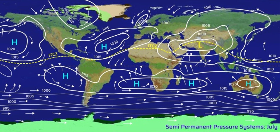
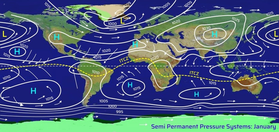
Seasonal Shifting of Pressure Belts
The pressure belts are not stationary. They shift northward in July and southward in January with the apparent movement of the sun:
July (Northern Hemisphere Summer):
- The sun is overhead at the Tropic of Cancer (23.5°N).
- All pressure belts shift northward.
- The thermal equator (ITCZ) lies north of the geographical equator.
January (Northern Hemisphere Winter):
- The sun is overhead at the Tropic of Capricorn (23.5°S).
- All belts shift southward.
- The shift in the Southern Hemisphere is less pronounced due to the moderating influence of vast oceans.
Global Pressure Belts
Pressure Belt | Latitudinal Extent | Nature | Formation | Climate Features |
Equatorial Low (Doldrums / ITCZ) | 5°–10° N & S (shifts seasonally) | Thermal Low | Intense heating, convection, convergence of trades | Calm, moist, convectional rainfall, thunderstorms |
Sub-Tropical High (Horse Latitudes) | ~30° N & S | Dynamic High | Descending dry air due to Coriolis force & subsidence | Arid, clear skies, deserts, calm anticyclonic conditions |
Sub-Polar Low | 45°–65° N & S | Dynamic Low | Convergence of westerlies & polar easterlies | Storm tracks, cyclones, jet streams |
Polar High | 80°–90° N & S | Thermal High | Cooling, subsiding cold dense air | Cold, dry polar easterlies |
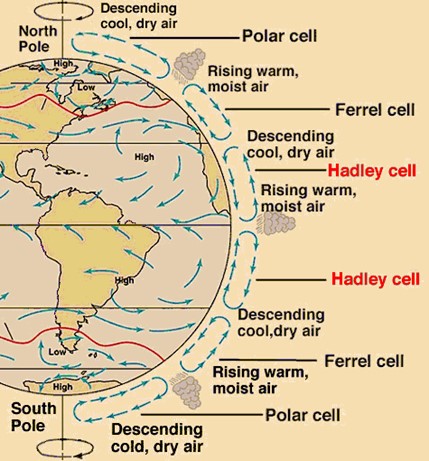
Three-Cell Model of Atmospheric Circulation
To explain the global wind system, the atmosphere is conceptualized into three distinct circulation cells in each hemisphere: Hadley Cell, Ferrel Cell, and Polar Cell. Together, they form a closed system of energy and momentum transfer.
1.Hadley Cell (Tropical Circulation)
Formation:
- Intense heating at the Equatorial Low-Pressure Belt (ITCZ) causes air to rise vigorously due to convection.
- The rising air reaches the tropopause (≈14 km altitude), spreads poleward, and descends near 30° N and S, forming the Subtropical High-Pressure Belts (Horse Latitudes).
Surface Winds:
- Part of the air returns towards the equator as the Trade Winds (NE Trades in the Northern Hemisphere and SE Trades in the Southern Hemisphere).
- These winds converge at the ITCZ, sustaining convectional rainfall and thunderstorms in equatorial regions.
Climatic Significance:
- Creates tropical rainforests at the equator (Amazon, Congo, Indonesia).
- Responsible for the formation of great deserts (Sahara, Thar, Kalahari, Atacama) along 30° N and 30° S, where descending dry air dominates.
Key Point:
- The Hadley Cell is the most powerful heat engine of the atmosphere and crucial for tropical climate dynamics.
2. Ferrel Cell (Mid-Latitude Circulation)
Formation:
- Situated between 30° and 60° latitudes, this is an indirect cell, driven by the interaction between the Hadley and Polar cells.
- Warm air rises at sub-polar lows (60° N/S) and sinks at subtropical highs (30° N/S).
Surface Winds:
- Generates the Westerlies, blowing from the subtropical high-pressure belt towards the sub-polar low-pressure belt.
Climatic Significance:
- Controls the weather in the temperate regions.
- Responsible for the frequent cyclonic activity and storm tracks over oceans and continents in mid-latitudes.
- Westerlies carry moisture to western coasts of continents, giving rise to Mediterranean climate (e.g., Spain, California, Cape Town, Western Australia).
Key Point:
- The Ferrel Cell is a thermally indirect cell, unlike the Hadley and Polar cells.
3. Polar Cell (High-Latitude Circulation)
Formation:
- Cold, dense air subsides at the Polar Highs (90° N/S) and moves equatorward.
- At 60° N/S, this cold air meets the warmer westerlies, rises, and returns aloft towards the poles.
Surface Winds:
- Produces the Polar Easterlies, which blow from east to west.
Climatic Significance:
- Polar regions remain extremely cold and dry.
- The meeting of cold Polar Easterlies and warm Westerlies at 60° N/S creates a Polar Front, a zone of intense instability that gives rise to cyclonic disturbances and the Polar Jet Stream.
Key Point:
- The Polar Cell is thermally direct, similar to the Hadley Cell, but much weaker due to limited solar heating.
Classification of Winds: Permanent, Periodic, and Local Systems
The movement of air across the Earth’s surface is one of the most fundamental processes of climatology. Winds arise due to differences in atmospheric pressure, created by the uneven heating of the Earth’s surface. The study of winds is essential for understanding weather systems, ocean circulation, and climate patterns, all of which play a decisive role in agriculture, navigation, and human settlements.
Winds are broadly classified into Permanent (Planetary) Winds, Periodic or Seasonal Winds, and Local Winds. Each of these has distinct mechanisms of origin, characteristics, and geographical impacts.
1. Permanent or Planetary Winds
Also called Primary or Prevailing Winds, these blow almost in the same direction throughout the year and cover vast portions of the globe. They are driven by the global pressure belt system and the Coriolis force. The three major categories are:
(a) Trade Winds
- Origin & Direction: These winds blow from the Subtropical High-Pressure Belts (30° N & S) towards the Equatorial Low-Pressure Belt (ITCZ).
- In the Northern Hemisphere, they blow as North-East Trades, while in the Southern Hemisphere, they blow as South-East Trades.
- Nature: At their origin, trade winds are stable, dry, and descending, but as they cross oceans, they absorb moisture and heat, becoming warm and humid by the time they reach the equator.
- Rainfall: The convergence of trade winds at the ITCZ leads to vertical uplift and heavy rainfall, creating dense equatorial rainforests (e.g., Amazon, Congo Basin).
- Asymmetry: The eastern margins of trade winds, influenced by cold ocean currents, remain dry and stable, while western margins, flowing over warm waters, are moist and unstable. This explains why western coasts in the tropics receive heavy rainfall.
(b) Westerlies
- Origin & Direction: Westerlies blow from the Subtropical High-Pressure Belt (30° N/S) towards the Sub-Polar Low-Pressure Belt (60° N/S).
- In the Northern Hemisphere, they move southwest to northeast, while in the Southern Hemisphere, they blow northwest to southeast.
- Intensity: The Southern Hemisphere Westerlies are stronger and more persistent due to uninterrupted oceanic surfaces, while in the Northern Hemisphere, they are irregular because of obstructing continents and mountain barriers.
- Roaring Forties, Furious Fifties, and Shrieking Sixties: Between 40° and 65° S latitudes, the Westerlies are extremely powerful due to the absence of land barriers, posing historical challenges to sailors.
- Climatic Role: Westerlies are associated with storm tracks, cyclonic activity, and precipitation in temperate zones. They are also responsible for the Mediterranean climate rainfall on the western margins of continents.
(c) Polar Easterlies
- Origin & Direction: These are cold, dry, dense winds blowing outward from the Polar Highs (90° N/S) towards the Sub-Polar Lows (60° N/S).
- They blow from northeast to southwest in the Northern Hemisphere and southeast to northwest in the Southern Hemisphere.
- Climatic Role: Polar easterlies reinforce the frigid conditions of polar regions and interact with Westerlies at the Polar Front, generating cyclonic disturbances that strongly influence mid-latitude weather.
2. Secondary or Periodic Winds
Unlike planetary winds, these winds change their direction periodically, either seasonally or daily, depending on local temperature and pressure variations.
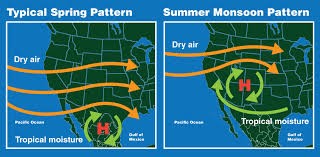
(a) Monsoons
- Definition: Monsoons are seasonally reversing winds, characterized by a complete reversal in wind direction between summer and winter.
- Mechanism:
- Summer (Southwest Monsoon): With the northward migration of the Sun, intense low pressure develops over the Indian subcontinent. The southeast trades from the Southern Hemisphere cross the equator, get deflected by the Coriolis force, and approach India as the Southwest Monsoon, bringing torrential rainfall.
- Winter (Northeast Monsoon): During winter, high pressure develops over continental Asia, and winds diverge towards the equatorial region. These Northeast Monsoon winds are dry over the interior but bring rain to the east coast of India (Tamil Nadu) after crossing the Bay of Bengal.
- Geographical Extent: Monsoon winds affect South Asia, Southeast Asia, northern Australia, eastern China, and Japan. Outside India, winter monsoons are stronger than summer monsoons, especially in East Asia.
- Climatic Significance: Monsoons support agriculture, ecosystems, and water resources, but also cause floods, droughts, and cyclones.
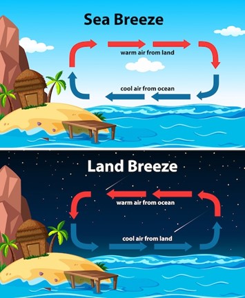
(b) Land and Sea Breezes
- Land Breeze (Night): At night, land cools faster than the sea. High pressure develops over land, and air moves from land to sea.
- Sea Breeze (Day): During the day, land heats up faster. Low pressure develops over land, and cooler air blows from sea to land, moderating coastal climates.
- Climatic Role: These breezes regulate diurnal temperature variations in coastal areas.
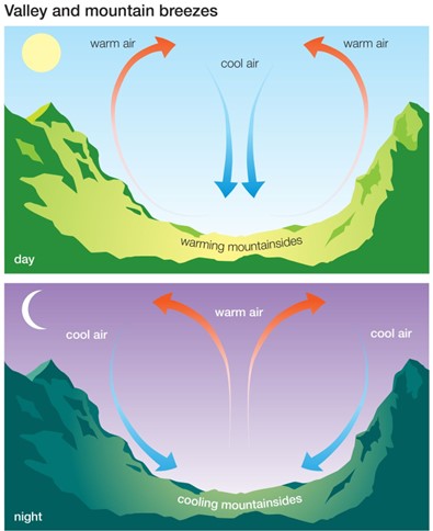
(c) Mountain and Valley Breezes
- Valley Breeze (Day): Slopes heat faster, and air rises upslope. Cooler air from the valley flows upward, creating a valley breeze.
- Mountain Breeze (Night): At night, slopes cool rapidly. Dense cold air drains downslope into valleys, forming a mountain breeze.
- Katabatic Winds: In high plateaus and glaciers, cold dense air flows downhill under gravity, termed katabatic winds.
- Climatic Role: These breezes influence microclimates in hilly regions and support frost protection in valleys.
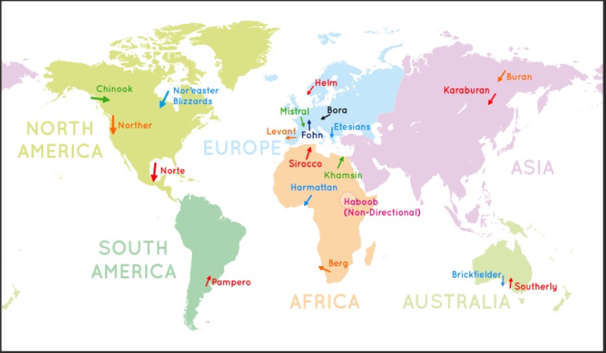
Tertiary or Local Winds
Local winds are produced due to regional differences in temperature and pressure. They are usually confined to the lowest layers of the troposphere and have distinct climatic impacts on the regions they affect.
Loo
- In the plains of northern India and Pakistan, a very hot and dry wind called the Loo blows during May and June afternoons.
- It originates from the deserts of Iran and Pakistan and moves eastward.
- Its temperature ranges between 45 °C and 50 °C, making it extremely oppressive and often dangerous to health.
Foehn (or Föhn)
- The Foehn is a dry, hot, gusty wind of the Alps, formed on the leeward side of mountains.
- As the incoming moist winds rise over the mountains, they lose moisture as orographic rainfall on the windward side, leaving the descending wind warm and dry.
- With temperatures between 15 °C and 20 °C, the Foehn melts snow, aids animal grazing, and helps in the ripening of grapes, making it agriculturally beneficial.
Chinook (“Snow Eaters”)
- The Chinook is a Foehn-like katabatic wind in the USA and Canada, blowing down the eastern slopes of the Rockies into the prairies.
- It can raise temperatures by about 5 °C within 20 minutes, rapidly melting snow.
- It benefits farmers and ranchers by keeping grasslands snow-free during winter.
- A regional variant of the Foehn in Argentina is known as the Zonda, affecting the eastern slopes of the Andes.
Sirocco
- The Sirocco is a hot, dry, and dusty wind originating from the Sahara and Arabian deserts.
- It is pulled northward by low-pressure systems moving eastward across the Mediterranean Sea.
- In North Africa and Southern Europe, it can reach hurricane-force speeds, scorching vegetation and crops.
- After crossing the Mediterranean, it absorbs moisture, often leading to storms at sea and cool, wet weather in Europe.
- Occasionally, it produces “blood rain”, caused by red Sahara dust mixing with precipitation.
Harmattan
- The Harmattan is a dry, dusty, north-easterly trade wind blowing from the Sahara and Sahel regions into West Africa.
- It is most intense between November and March, especially in Nigeria.
- The dense dust particles block sunlight, reducing daytime temperatures, while also worsening visibility and causing health problems like dry skin and respiratory issues.
Mistral
- The Mistral is a cold, strong wind blowing from the Alps down the Rhône Valley (France) towards the Mediterranean Sea.
- Its velocity is intensified by the funneling effect of the valley between the Alps and the Central Massif.
- It is very cold, dry, and violent, often bringing blizzards to southern France.
Similar Winds in the Region:
- Bora – Cold north-easterly wind along the Adriatic coast.
- Tramontane, Levanter, and Gregale – Other cold Mediterranean winds.
- Pampero – A burst of cold polar air sweeping across the pampas of Brazil, Argentina, Uruguay, Paraguay, and Bolivia.
Cold Winds | Region Affected | Warm Winds | Region Affected |
Pampero | Argentina | Foehn | Switzerland (northern slopes of Alps) |
Gregale | Malta & nearby Mediterranean islands | Chinook | Prairies (North America) |
Bora | Adriatic Coast | Zonda | Argentina (eastern slopes of Andes) |
Tramontane | Blows down the Alps into Italy | Loo | Indo-Gangetic plains (India) |
Mistral | Rhône Valley, France | Sirocco | North Africa & Southern Europe |
Harmattan | Dust-laden winds of Western Africa | Nor’wester | Canterbury Plains, New Zealand |
Levanter | Mediterranean coasts of France & Spain (foggy winds) | Santa Ana | California (hot, dry, dusty winds) |
Karaburan | Violent dry wind of Central Asia | Khamsin | Egypt (hot, dusty desert wind) |
Southerly Buster | New South Wales & Victoria, Australia | Brickfielder | Southern Australia (hot, dry wind) |
Nor’easter | Blizzard winds of Northeast Canada |
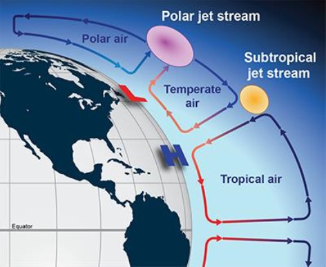
Jet Streams:
Jet streams are fast-moving, narrow bands of westerly winds in the upper troposphere, typically found near the tropopause (8–16 km altitude). These winds can reach astonishing speeds of 400–500 km/h, effectively acting as high-altitude “conveyor belts” for weather systems.
Formation and Characteristics
- Temperature Gradient: The primary driver is the contrast between warm tropical air and cold polar air. Greater contrasts in winter strengthen jet streams.
- Low Friction and Coriolis Force: The upper atmosphere’s low friction allows winds to accelerate, while the Coriolis force channels them into narrow, meandering currents.
- Seasonal Shifts: Jet streams migrate with the apparent movement of the sun—poleward in summer and equatorward in winter.
- Direction: Predominantly west to east, following the westerly circulation pattern in mid-latitudes.
Types of Jet Streams
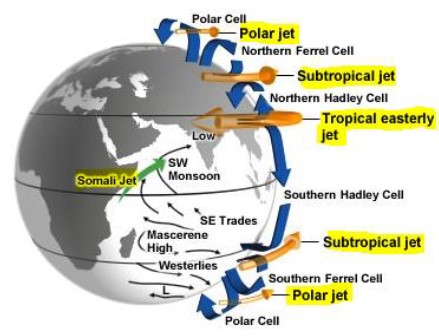
1. Permanent Jet Streams
- Subtropical Jet Stream (STJ): Found between the Hadley and Ferrel Cells at around 25°–35° latitude. The STJ is particularly continuous in the Southern Hemisphere, while in the Northern Hemisphere it weakens during summer. Importantly, it plays a decisive role in controlling the onset and withdrawal of the Indian Monsoon.
- Polar Front Jet Stream (PFJ): Occurs at about 50°–60° latitude where cold polar air meets warm westerlies. It is stronger and more regular in winter, when temperature contrasts are sharpest. The PFJ governs storm tracks and influences weather in North America, Europe, and Asia.
2. Temporary or Tropical Jet Streams
- Tropical Easterly Jet (TEJ): Dominant in the Northern Hemisphere summer between 5°–20° N. It develops due to intense heating of the Tibetan Plateau and influences South Asian monsoon rainfall. A weak TEJ often corresponds to monsoon droughts.
- Somali Jet: A seasonal jet that intensifies from June to August over northern Madagascar and off the coast of Somalia. It represents a major cross-equatorial flow that transports massive amounts of moisture into the Arabian Sea, thereby fuelling the South Asian monsoon.
Meandering of Jet Streams (Rossby Waves)
While jet streams are narrow and fast, they rarely flow in a straight path. Instead, they develop large wave-like undulations known as Rossby Waves.
Mechanism
- Coriolis Force & Angular Momentum: As air moves poleward, it speeds up due to proximity to Earth’s axis, while equatorward movement slows it down. This uneven acceleration creates oscillations.
- Influence of Surface Features: Large mountain ranges (e.g., Rockies, Himalayas) and ocean currents disrupt airflow, enhancing meandering.
- Seasonal & Climatic Variability: Shifting temperature contrasts in summer and winter influence the amplitude of these waves.
Impacts
- Heatwaves: When the jet stream locks northward, warm air stagnates, leading to extreme heat and drought (e.g., European and North American heatwaves).
- Cold Waves: When it dips southward, Arctic air invades mid-latitudes, triggering cold snaps and heavy snowfalls.
- Climate Change Effect: Global warming reduces the polar-tropical temperature gradient, weakening the jet stream and making it more meandering. This results in longer-lasting weather extremes such as prolonged droughts, heatwaves, or cold waves.
Significance of Jet Streams
- Influence on Monsoons: The shift of the subtropical jet is crucial for the onset and withdrawal of the Indian monsoon, making it a key subject in UPSC examinations.
- Agriculture and Economy: Seasonal rainfall variability linked to jet streams directly affects crop productivity and water resources.
- Global Climate System: Jet streams regulate energy transfer between latitudes, thus playing a fundamental role in balancing Earth’s heat budget.
- Aviation: Jet streams impact flight routes and fuel efficiency; airlines exploit tailwinds to save time and cost.
- Ozone Depletion: The meandering of polar jet streams encourages the formation of Polar Stratospheric Clouds (PSCs), which catalyse ozone depletion in high latitudes.
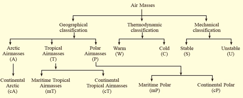
Air Masses:
The atmosphere is never static; it is constantly influenced by large bodies of air that carry distinct climatic properties. These vast parcels of air, extending horizontally for thousands of kilometers and vertically through the troposphere, are known as Air Masses. Their movement and interaction form the foundation of global weather systems and are crucial for understanding cyclones, rainfall distribution, and climatic variations.
What is an Air Mass?
An Air Mass is defined as a large body of air with uniform temperature, humidity, and pressure characteristics across its horizontal extent. It acquires these properties when it remains stationary over a particular surface—land or sea—for a considerable duration. Once formed, it can move away from its source region, carrying the thermal and moisture characteristics with it, thereby influencing the weather conditions of distant regions.
Source Regions of Air Masses
Air masses are created in specific source regions, which are vast, homogenous surfaces capable of imparting their climatic characteristics to the overlying air.
- Nature of Source Regions: Source regions are typically oceans, plains, plateaus, or ice-covered zones where conditions remain relatively stable for long periods.
- Heat and Moisture Transfer: Over time, the underlying surface transfers its heat and moisture content to the air above, allowing the air mass to acquire distinctive thermal and humidity profiles.
- Absence in Mid-Latitudes: Interestingly, mid-latitudes are not major source regions. This is because these areas are dominated by cyclonic activity, atmospheric disturbances, and shifting pressure belts, which prevent the formation of stable, homogenous air masses.
Types of Fronts
Fronts are classified based on the mechanism of interaction between the air masses:
1. Stationary Front
- Formed when two air masses meet but neither advances against the other.
- Wind movement remains parallel to the front, creating a state of balance.
- Weather: Prolonged cloudiness, drizzle, or light precipitation.
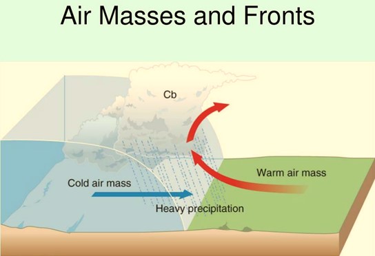
2. Cold Front
- Occurs when a cold, dense air mass aggressively advances, pushing under a warm, moist air mass.
- The cold front is usually steep and abrupt, forcing the warm air to rise quickly.
- Weather Effects: Formation of cumulonimbus clouds, heavy rainfall, thunderstorms, lightning, and sometimes tornadoes (common in the Great Plains of the USA).
3. Warm Front
- Formed when a warm air mass advances gradually over a cold, denser air mass.
- The slope of a warm front is gentle, leading to a gradual lifting of warm air.
- Weather Effects: Widespread cloud formation, prolonged steady rainfall or drizzle, and overcast skies.
4. Occluded Front
- Develops when a faster-moving cold front overtakes a warm front, lifting the warm air mass entirely off the ground.
- This results in the mixing of cold and warm fronts, often producing intense weather events.
- Weather Effects: Heavy rainfall, thunderstorms, and stormy conditions; sometimes linked to severe mid-latitude cyclones.
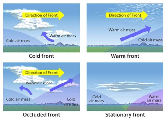
Climatological Importance of Fronts
- Drivers of Temperate Cyclones: Fronts are the birthplaces of mid-latitude depressions, which dominate the weather of temperate regions.
- Precipitation Patterns: They account for most rainfall in mid-latitudes, influencing agriculture and water resources.
- Weather Variability: By separating contrasting air masses, fronts create conditions for instability, storms, and rapid weather changes.
Water in the Atmosphere
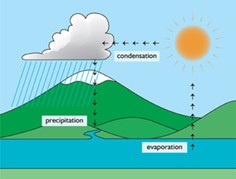
The hydrological cycle is the continuous process through which water circulates between the oceans, land, and atmosphere, sustaining life and regulating climate. Within this cycle, the atmosphere plays a central role by storing water in the form of vapour, clouds, and precipitation, thereby linking terrestrial and oceanic systems. The amount and movement of water vapour determine weather phenomena, rainfall, fog, and atmospheric stability.
Humidity:
Humidity refers to the presence of water vapour in the air, which is a decisive factor in determining comfort, precipitation, and cloud formation.
- Absolute Humidity (AH): The actual mass of water vapour present in a unit volume of air, usually expressed in grams per cubic metre. It depends directly on air temperature and is higher over oceans than over land.
- Relative Humidity (RH): The ratio (in percentage) of the current moisture in the atmosphere to the maximum it can hold at a given temperature. It is the most widely used measure, since 100% RH denotes saturated air, leading to condensation.
- Specific Humidity (SH): Represents the mass of water vapour per unit mass of air. Unlike AH, it remains unaffected by changes in pressure or temperature, making it a more reliable measure in climatological studies.
- Saturated Air: When RH reaches 100%, the air cannot hold more water vapour. Any further cooling or moisture addition causes condensation.
- Unsaturated Air: When RH is less than 100%, the air is capable of absorbing more vapour.
- Dew Point Temperature: The temperature at which air becomes saturated and condensation begins. This is a critical indicator for predicting dew, fog, or frost formation.
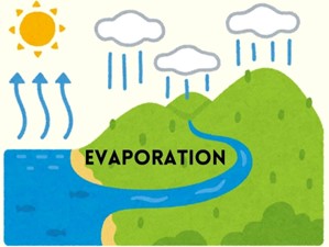
Evaporation:
Evaporation is the process by which water changes from liquid to gaseous form. It is a fundamental step of the hydrological cycle and is influenced by several factors:
- Latent Heat of Vaporisation: A large amount of heat is required to convert liquid water into vapour without raising its temperature. This latent heat is stored in vapour and released during condensation.
- Controlling Factors:
- Temperature: Higher temperatures accelerate evaporation.
- Humidity: Dry air promotes faster evaporation compared to moist air.
- Wind Movement: Strong winds replace saturated air with dry air, increasing evaporation.
- Atmospheric Pressure & Salinity: Low pressure and saline water enhance evaporation rates.
- Global Pattern: Evaporation is highest over the tropical oceans and decreases towards the poles. The western North Atlantic shows some of the highest evaporation rates globally.
Condensation:
Condensation is the process by which water vapour transforms into liquid or solid state when air is cooled to its dew point or saturated with moisture.
- Sublimation: When vapour converts directly into solid ice crystals (e.g., frost, snow).
- Conditions for Condensation:
- Cooling of air to the dew point temperature.
- Reduction in temperature and volume simultaneously.
- Addition of moisture through evaporation.
- Condensation Nuclei: Microscopic particles like dust, smoke, pollen, and sea salt act as surfaces for vapour to condense.
Forms of Condensation
1. Dew: Moisture deposited on cool surfaces as droplets. Favourable conditions include clear skies, calm winds, high RH, and long cold nights.
- If air temperature is below freezing, frost forms instead of dew.
2. Fog: Essentially a cloud at ground level, formed when air cools suddenly near the surface.
- Radiation Fog: Caused by rapid nocturnal cooling of land.
- Advection Fog: Warm moist air passing over a cold surface.
- Upslope Fog: Air lifted up a slope cools adiabatically.
- Steam Fog: When cold air moves over warm water (common over lakes and seas).
3. Mist: Denser than haze but lighter than fog, usually in mountainous areas with >75% RH.
4. Haze: Reduced visibility due to fine dust or pollutants under low humidity (<75%).
5. Smog: A mixture of smoke and fog; a major urban hazard.
- Classical Smog: Coal combustion in cold, humid climates (London smog).
- Photochemical Smog: Summer smog caused by reaction of NOx and VOCs with sunlight, producing ozone, PAN, and aldehydes (Los Angeles smog).
- Volcanic Smog (VOG): Sulphur dioxide and aerosols from volcanic eruptions.
Climatological Significance
- Humidity and condensation processes directly influence cloud formation and precipitation patterns.
- Evaporation and condensation together drive the energy balance of the Earth’s atmosphere, with latent heat exchanges playing a critical role in cyclones, monsoons, and thunderstorms.
- Fog and smog have significant economic and health implications, affecting aviation, transport, and human well-being.
Types of Fronts
Fronts are classified based on the mechanism of interaction between the air masses:
1. Stationary Front
- Formed when two air masses meet but neither advances against the other.
- Wind movement remains parallel to the front, creating a state of balance.
- Weather: Prolonged cloudiness, drizzle, or light precipitation.
2. Cold Front
- Occurs when a cold, dense air mass aggressively advances, pushing under a warm, moist air mass.
- The cold front is usually steep and abrupt, forcing the warm air to rise quickly.
- Weather Effects: Formation of cumulonimbus clouds, heavy rainfall, thunderstorms, lightning, and sometimes tornadoes (common in the Great Plains of the USA).
3. Warm Front
- Formed when a warm air mass advances gradually over a cold, denser air mass.
- The slope of a warm front is gentle, leading to a gradual lifting of warm air.
- Weather Effects: Widespread cloud formation, prolonged steady rainfall or drizzle, and overcast skies.
4. Occluded Front
- Develops when a faster-moving cold front overtakes a warm front, lifting the warm air mass entirely off the ground.
- This results in the mixing of cold and warm fronts, often producing intense weather events.
- Weather Effects: Heavy rainfall, thunderstorms, and stormy conditions; sometimes linked to severe mid-latitude cyclones.
Climatological Importance of Fronts
- Drivers of Temperate Cyclones: Fronts are the birthplaces of mid-latitude depressions, which dominate the weather of temperate regions.
- Precipitation Patterns: They account for most rainfall in mid-latitudes, influencing agriculture and water resources.
- Weather Variability: By separating contrasting air masses, fronts create conditions for instability, storms, and rapid weather changes.
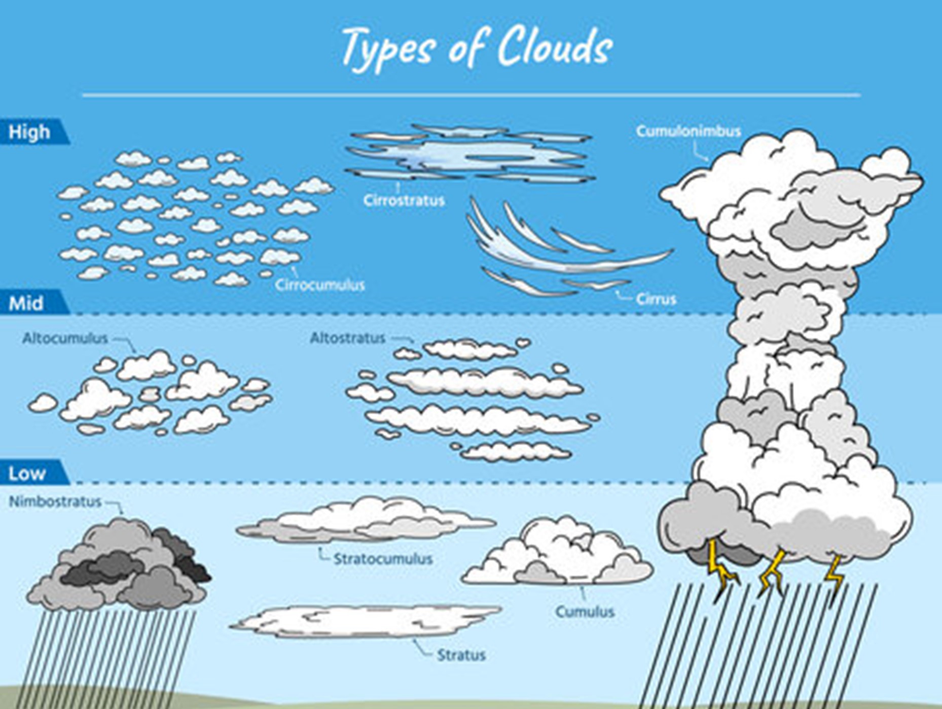
Clouds:
Clouds are among the most striking and dynamic features of the Earth’s atmosphere. They are essentially visible masses of tiny water droplets or ice crystals (around 0.02 mm in diameter) that form when water vapour condenses on condensation nuclei such as dust, smoke, or sea salt particles, high above the Earth’s surface.
Clouds perform a dual climatic function:
- They cool the Earth’s surface by reflecting a portion of the incoming solar radiation back into space (albedo effect).
- At the same time, they retain and re-radiate longwave terrestrial radiation, contributing to the greenhouse effect and warming the lower atmosphere.
Thus, clouds act as both a regulator and modifier of climate, playing a pivotal role in the hydrological cycle, weather forecasting, and global energy balance.
Major Cloud Types
1. Cirrus Clouds
- Appearance: Thin, fibrous, and feathery clouds, resembling delicate brush strokes across the sky. They are always white and give the sky a graceful appearance.
- Altitude: Found very high in the atmosphere, typically between 8,000–12,000 m, in the upper troposphere.
- Composition: Made up entirely of ice crystals because of the extremely low temperatures at such altitudes.
- Significance: Act as precursors of weather changes, often signaling the approach of a warm front or storm system.
2. Nimbus Clouds
- Appearance: Dense, dark gray, and shapeless masses that completely block sunlight. Their opacity gives the sky a gloomy look.
- Altitude: Found at low to intermediate levels, often close to the Earth’s surface.
- Weather Role: These are the primary rain-bearing clouds, producing continuous precipitation over a large area.
- Special Type – Cumulonimbus: Towering thunderclouds that stretch vertically through the troposphere. They generate thunderstorms, lightning, hailstorms, and tornadoes, making them one of the most dangerous weather-producing systems.
3. Stratus Clouds
- Appearance: Uniform, featureless gray sheets that cover the sky like a blanket, creating an overcast condition.
- Formation: Arise due to the cooling of air near the ground or mixing of warm and cold air masses.
- Weather Effect: Typically bring light rain, drizzle, or snow. They are associated with dull, damp, and gloomy weather.
4. Cumulus Clouds
- Appearance: Puffy, cotton-like clouds with flat bases and rounded tops. They often look like floating heaps of wool.
- Altitude: Form at 4,000–7,000 m, mainly during the daytime due to convection currents.
- Weather Impact: Indicate fair and stable weather when small, but if they develop vertically into cumulonimbus, they can trigger intense storms.
Precipitation:
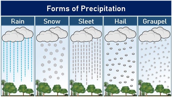
Precipitation is one of the most fundamental processes in the Earth’s hydrological cycle. It refers to the fall of condensed water vapour from the atmosphere to the Earth’s surface in various forms such as rain, snow, sleet, hail, or drizzle. It plays a crucial role in replenishing freshwater resources, sustaining ecosystems, and shaping landforms through erosion and deposition.
Precipitation occurs when water vapour in the atmosphere condenses into larger droplets or ice crystals. Once these droplets grow beyond the capacity of air to hold them against the pull of gravity, they fall to the ground. The type of precipitation depends on the temperature, humidity, altitude, and atmospheric conditions.
Forms of Precipitation
1. Rainfall
- Occurs when water droplets larger than 0.5 mm fall from clouds.
- The most common and widespread form of precipitation.
- Essential for agriculture, groundwater recharge, and maintaining the hydrological balance.
2. Virga
- Refers to rain droplets that evaporate before reaching the Earth’s surface due to dry air layers.
- Common in arid and semi-arid regions where evaporation exceeds precipitation.
3. Drizzle and Mist
- Drizzle: Light rain with droplets smaller than 0.5 mm, usually falling from low stratus clouds.
- Mist: Formed when drizzle evaporates before reaching the ground, creating a thin veil of moisture and reduced visibility.
4. Snowfall
- Occurs when atmospheric moisture condenses and freezes directly into hexagonal ice crystals, forming fine flakes.
- Found in temperate, polar, and high-altitude regions where air temperature remains below 0°C.
5. Sleet
- Consists of frozen raindrops or refrozen melted snow.
- Formed when raindrops pass through a warm layer of air before falling into a sub-freezing layer near the ground, solidifying into ice pellets.
6. Hailstones
- Rounded pellets of ice, typically 5–50 mm in diameter.
- Produced when raindrops are carried upward by strong convection currents inside cumulonimbus clouds, freeze, and accumulate successive concentric layers of ice.
- Common in regions of intense thunderstorms.
Types of Rainfall
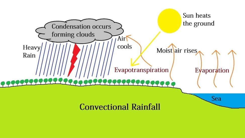
1. Convectional Rainfall
- Occurs when intense solar heating warms the Earth’s surface, causing air to rise in convection currents.
- As the air ascends, it expands, cools, and condenses, forming cumulus or cumulonimbus clouds.
- Produces heavy but short-duration showers, often accompanied by thunder and lightning.
- Typical in equatorial regions (Congo Basin, Amazon Basin, Southeast Asia).
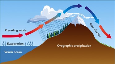
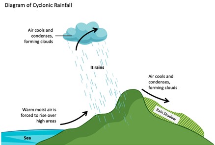
2. Orographic or Relief Rainfall
- Occurs when moist air is forced to rise over mountain barriers.
- On the windward side, air cools adiabatically, leading to condensation and heavy rainfall (e.g., Cherrapunji and Mawsynram, receiving the world’s heaviest rainfall).
- On the leeward side, dry descending air creates a rain-shadow region with arid or semi-arid conditions.
- Examples: Pune (rain shadow of Western Ghats), Patagonian Desert (Argentina), Atacama Desert (Chile).
3. Cyclonic or Frontal Rainfall
- Associated with cyclones and atmospheric fronts where warm moist air meets cold dry air.
- At the cold front, dense cold air forces lighter warm air to rise abruptly, resulting in heavy rainfall, thunderstorms, and even tornadoes (common in the USA).
- At the warm front, warm air gradually rises over cold air, producing widespread, gentle, and continuous rainfall.
- In occluded fronts, a cold air mass overtakes a warm air mass, lifting it completely and causing prolonged rainfall over large areas.
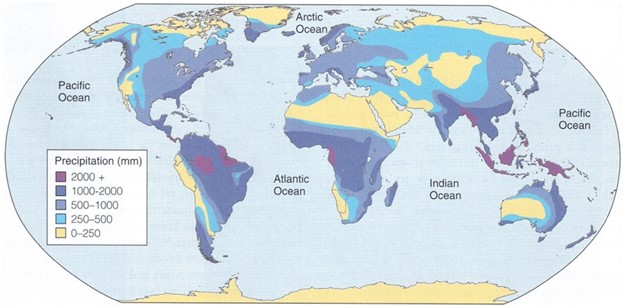
Global Distribution of Rainfall
- Equatorial Regions: Receive the heaviest and most consistent rainfall throughout the year due to convectional rainfall and ITCZ migration.
- Tropical Monsoon Regions: Experience seasonal rainfall, concentrated during summer monsoons.
- Subtropical Deserts (20°–30° N & S): Receive very low rainfall (<25–50 cm annually) due to the presence of subtropical high-pressure belts. Examples: Sahara, Kalahari, Atacama.
- Mid-Latitude Regions (35°–65° N & S): Rainfall is moderate, largely influenced by westerlies and cyclonic activity.
- High Latitude and Polar Regions (65°–90°): Receive very little precipitation, mostly in the form of snow, due to cold and dry conditions.
- Coastal vs. Inland Areas: Coastal regions receive more rainfall than interiors because moist winds lose much of their water before reaching continental interiors.
- Asymmetry in Distribution: In 35°–40° latitudes, eastern coasts receive more rainfall (due to moist easterlies), while in 45°–65° latitudes, western coasts receive higher rainfall (due to prevailing westerlies).
Cyclones:
A cyclone is a large-scale atmospheric disturbance characterized by a low-pressure centre around which winds spiral. The term broadly refers to any circulating system of winds, but in climatology, cyclones are classified based on their place of origin and nature of development into two broad categories:
- Tropical Cyclones – originating over warm tropical oceans.
- Temperate (Extratropical) Cyclones – forming in the mid- and high-latitude regions, typically along the polar fronts.
In the Northern Hemisphere, cyclonic winds move anticlockwise, while in the Southern Hemisphere, they rotate clockwise due to the Coriolis effect. Conversely, winds around high-pressure centres move clockwise in the Northern Hemisphere and anticlockwise in the Southern Hemisphere, forming anticyclones.
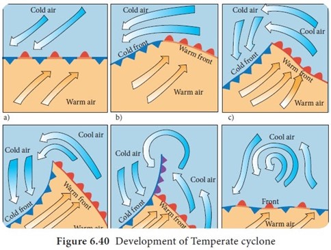
Temperate (Extratropical) Cyclones
Temperate cyclones, also called wave cyclones, mid-latitude cyclones, or depressions, are large-scale low-pressure systems that dominate the mid and high latitudes (35°–65° N & S).
Formation Process
- They develop along the polar front, the convergence zone where cold polar air masses meet warm tropical air masses.
- A disturbance forms along the front due to pressure differences, which intensify under the influence of the Coriolis force, creating an anticlockwise circulation in the Northern Hemisphere (clockwise in the Southern Hemisphere).
- This results in the development of two types of fronts:
- Warm Front: Warm, lighter air gradually rises over denser cold air, producing prolonged and moderate rainfall across large areas.
- Cold Front: Cold air wedges beneath warm air, lifting it abruptly and leading to intense rainfall, thunderstorms, and sometimes cyclonic storms.
- When the cold front overtakes the warm front, the warm air is completely lifted off the ground, forming an occluded front, which eventually weakens the cyclone.
Climatic Importance
- They are most common in winter, late autumn, and early spring.
- Temperate cyclones move from west to east with the westerlies.
- The polar jet streams play a crucial role in their formation and trajectory.
- In India, the western disturbances experienced in North India during winter are remnants of temperate cyclones.
Tropical Cyclones
Tropical cyclones are intensely powerful low-pressure systems that originate over warm oceanic waters of tropical regions. They are among the most destructive natural hazards, producing violent winds, torrential rainfall, and devastating storm surges.
Key Features
- Size: Compact systems, ranging between 80 km to 2,000 km in diameter.
- Eye of the Cyclone: A nearly circular, calm, and clear zone at the centre with the lowest pressure and relatively higher temperature. The eye is surrounded by the eye wall, where the strongest winds and heaviest rainfall occur.
- The eye can be up to 10°C warmer than the surrounding environment at higher altitudes, but only 1–2°C warmer at the surface. [UPSC 2020]
- Energy Source: Powered by the latent heat of condensation released when warm, moist air rises and condenses.
- Movement: They generally move westward with the trade winds, later curving poleward due to the Coriolis force, forming a parabolic trajectory.
- Dissipation: Cyclones weaken rapidly after landfall, as their primary energy source—moisture from warm ocean surfaces—is cut off.
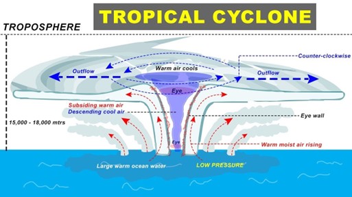
Favourable Conditions for Formation
- Sea surface temperature above 27°C, extending to a depth of at least 60 m.
- Abundant moisture in the atmosphere.
- Strong Coriolis force (hence, they do not form near the equator, i.e., between 0°–5° latitude).
- Weak vertical wind shear to allow vertical growth of convection.
- Pre-existing low-pressure system or atmospheric disturbance.
- Upper air divergence, which helps evacuate rising air and sustain cyclonic circulation.
Global Nomenclature
- Cyclones – Indian Ocean and South Pacific.
- Hurricanes – Atlantic Ocean and Eastern Pacific.
- Typhoons – Western Pacific and South China Sea.
- Willy-Willies – North-West Australia.
Cyclones and Anticyclones
System | Pressure at Centre | Northern Hemisphere Wind Direction | Southern Hemisphere Wind Direction | Weather Conditions |
Cyclone | Low Pressure | Anticlockwise rotation | Clockwise rotation | Cloudy skies, heavy rainfall, storms |
Anticyclone | High Pressure | Clockwise rotation | Anticlockwise rotation | Clear skies, calm and stable weather |
Significance of Cyclones
- Redistribution of Heat: Tropical and temperate cyclones transport heat and moisture from low to high latitudes, balancing global temperature.
- Rainfall Contribution: Tropical cyclones bring abundant rainfall, replenishing water sources but also causing floods.
- Impact on Human Life: While cyclones can cause devastating destruction, storm surges, and loss of life, they are also crucial for maintaining climatic equilibrium and sustaining ecosystems.
- Role in South Asia: The Southwest Monsoon in India is directly influenced by the Subtropical Jet Stream (STJ) and the Tropical Easterly Jet (TEJ), which are linked to cyclonic systems in the Indian Ocean.
Comparison of Tropical Cyclones and Temperate Cyclones in a clear table format:
Characteristic | Tropical Cyclone | Temperate Cyclone |
Origin | Thermal Origin | Dynamic Origin – Coriolis Force, Movement of Air Masses |
Latitude | 10–30° N and S of the equator | 35–65° N and S of the equator; more pronounced in the Northern Hemisphere due to greater temperature contrast |
Frontal System | Absent | Formation due to frontogenesis |
Formation | Forms at sea (>26–27°C); dissipates on land | Can form on both land and sea |
Season | Seasonal: Late summers (Aug–Oct) | Irregular; fewer in summers, more in winters |
Size | Smaller area: 100–500 km diameter | Larger area: 300–2000 km diameter |
Shape | Elliptical, Anvil-shaped | Inverted ‘V’ (middle latitude cyclones) |
Rainfall | Heavy but short-lasting | Slow, continuous rainfall for days or weeks |
Wind Velocity | Much greater (100–250 kmph) | Comparatively low (30–150 kmph) |
Isobars | Complete circles, steep pressure gradient | ‘V’-shaped, low pressure gradient |
Lifetime | Less than 1 week | 2–3 weeks |
Path | East to West (Trade Winds) | West to East (Westerlies) |
Calm Region | Eye at the center, calm with no rainfall | No specific calm region |
Driving Force | Energy from latent heat of condensation | Energy depends on air mass densities |
Influence of Jet Streams | Relationship with upper-level airflow less clear | Strong relationship with Jet Streams and Rossby Waves |
Clouds | Few varieties (Cumulonimbus, Nimbostratus) | Wide variety of clouds at different elevations; occluded front clouds |
Influence on India | Affects both coasts; East coast more impacted | Brings rains to Northwest India; associated with Western Disturbances |
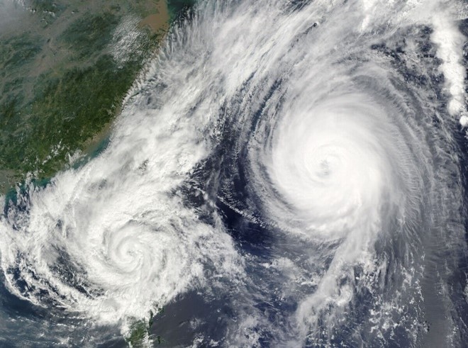
Twin Cyclones
Twin cyclones refer to two tropical cyclones forming simultaneously on either side of the equator, generally within the same longitude, but located in opposite hemispheres.
Cause:
- These cyclones are primarily generated by Equatorial Rossby waves (also known as planetary or inertial waves) that develop due to Earth’s rotation and influence atmospheric disturbances near the equator.
Characteristics:
- Usually form at the same time from a common equatorial disturbance.
- Rotate in opposite directions—anticlockwise in the Northern Hemisphere and clockwise in the Southern Hemisphere, due to the Coriolis effect.
- Appear as mirror images in terms of structure and often have comparable intensities since both hemispheres share similar thermal and moisture conditions.
Favourable Conditions:
- Warm ocean waters (>27°C), high moisture content, low vertical wind shear, and positive vorticity.
- Development begins as tall vortices near the equator, which then drift westward under the influence of trade winds.
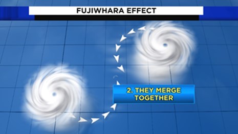
Fujiwhara Effect
A related but distinct phenomenon is the Fujiwhara Effect, which occurs when two cyclones form in the same hemisphere within ~1,400 km of each other.
- Mechanism: The two systems begin to rotate cyclonically around a common centre, sometimes merging into a single, larger cyclone, or in other cases, repelling each other.
- Difference from Twin Cyclones: Unlike twin cyclones (which form on opposite sides of the equator and rotate in opposite directions), the Fujiwhara effect occurs between same-hemisphere cyclones that rotate in the same direction.
- Impact: Alters the track, intensity, and lifespan of storms, increasing unpredictability.
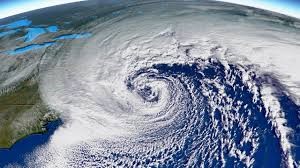
Bomb Cyclones
A bomb cyclone (or explosive cyclogenesis) is a rapidly intensifying mid-latitude storm system, where the atmospheric pressure drops by at least 24 millibars within 24 hours.
Formation:
- Develops at the boundary of contrasting air masses—cold, dense polar air colliding with warm, moist tropical air.
- The sharp temperature gradient generates an intense pressure drop.
- Rapid upward movement of warm air, combined with strong winds, fuels the system.
Characteristics:
- Extremely strong winds, often reaching hurricane-force speeds (400–500 km/h in jet-level winds).
- Can trigger heavy snowstorms, blizzards, and coastal flooding.
- Most common along the east coast of North America during winter, where cold Arctic air meets the warm Gulf Stream.
Case Example:
- The 2018 Bomb Cyclone over the northeastern United States caused record snowfall, storm surges, and hurricane-strength winds, severely disrupting life and infrastructure.
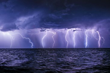
Thunderstorms
Thunderstorms are short-lived but intense weather phenomena associated with towering cumulonimbus clouds.
Formation:
- Result from intense convection during hot and humid conditions.
- Warm, moist air rises rapidly, cools, and condenses, releasing latent heat that further energizes the system.
Characteristics:
- Produce thunder, lightning, heavy rainfall, and strong gusty winds. [UPSC 2013]
- Generally occur in localized pockets and last for a short duration.
- At higher altitudes, moisture freezes, leading to hailstorms, while in dry regions, thunderstorms may create dust storms.
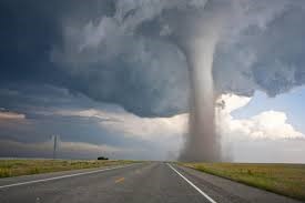
Tornadoes
A tornado is a violently rotating column of air, extending from a cumulonimbus cloud to the ground, with extremely low pressure at the centre.
- Appearance: Often resembles the trunk of an elephant or a funnel-shaped cloud.
- Characteristics:
- Extremely destructive due to high wind speeds and suction effect.
- Usually confined to small areas, but capable of devastating entire settlements.
- Over oceans or seas, tornadoes are known as waterspouts.
- Geographical Distribution: Most common in mid-latitude regions, especially in Tornado Alley (USA), where warm moist air from the Gulf meets cold polar air.
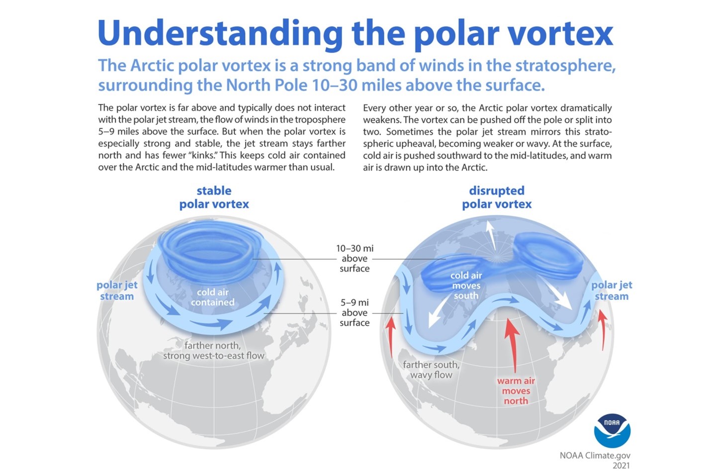
Polar Vortex
The Polar Vortex is a large, persistent area of low pressure and extremely cold air surrounding both poles.
- Nature: Exists year-round, but it weakens during summer and intensifies in winter.
- Wind Circulation: Exhibits a counter-clockwise circulation in the Northern Hemisphere, acting like a whirling dome of cold air confined by the polar jet streams.
- Climatic Role:
- Helps keep frigid polar air contained near the poles.
- When the vortex weakens or breaks apart, cold Arctic air can spill southwards, leading to severe cold waves in mid-latitude regions (e.g., North America, Europe, northern India).
- A disrupted vortex has been increasingly linked with climate change, as Arctic warming reduces the temperature gradient that stabilizes it.
During winters, the polar vortex intensifies and expands, while the polar front jet streams shift closer to the Equator. As a result, a portion of the vortex may split and extend into the mid-latitudes, a phenomenon known as a Polar Outbreak, which brings severe cold waves to these regions. For example, large Arctic air outbreaks often affect the United States.
El Niño, La Niña, ENSO and Indian Monsoon
The warming and cooling of the Pacific Ocean have a profound impact on global atmospheric circulation and climatic patterns. These phenomena—popularly known as El Niño, La Niña, and ENSO—are closely linked to the Walker Circulation and play a decisive role in shaping rainfall, droughts, floods, and agricultural outcomes across the world, including the Indian Monsoon system.
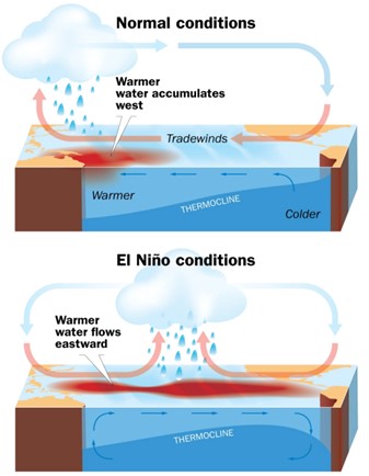
Normal Conditions and Walker Circulation
Under normal years, the Pacific Ocean exhibits a clear east–west contrast:
- A low-pressure system develops over Northern Australia and Indonesia.
- A high-pressure system dominates the coast of Peru and Ecuador.
This pressure gradient strengthens the easterly trade winds, which:
- Push warm surface waters westward, causing convectional rainfall and thunderstorms over Indonesia and Australia.
- Allow cold, nutrient-rich waters to upwell along Peru and Ecuador, supporting one of the world’s richest fisheries.
Thus, normal years are marked by warm water accumulation in the Western Pacific, cold upwelling in the Eastern Pacific, and a functioning Walker Circulation with intense rainfall in Asia-Pacific and calm, dry conditions in South America.
El Niño and Southern Oscillation (ENSO)
El Niño Phenomenon
El Niño refers to the occasional warming of ocean surface waters along the coast of Peru and Ecuador. During an El Niño year:
- Air pressure falls over the Eastern Pacific and rises over the Western Pacific, weakening or reversing the Walker Cell.
- The trade winds slacken, allowing the Equatorial Counter Current (west-to-east flow) to push warm water into the Eastern Pacific.
- Thermocline depth increases in the east, cutting off nutrient upwelling and disrupting fisheries.
- Climatic consequences:
- Droughts in Australia, Indonesia, India, and Southern Africa.
- Floods and heavy rainfall in Peru, Ecuador, and California.
- Storms and hurricanes in the Central Pacific.
El Niño events typically develop around Christmas (hence the name) and may last a few months to over a year.
ENSO (El Niño–Southern Oscillation)
The Southern Oscillation refers to the inter-annual fluctuation of pressure systems across the tropical Pacific:
- Low pressure over Eastern Pacific (Tahiti region).
- High pressure over Western Pacific (Darwin, Australia).
When combined with the warming of ocean waters (El Niño), this system is called ENSO. It is the most powerful coupled ocean–atmosphere interaction influencing global climate.
ENSO years lead to drought in monsoon Asia, floods in the Americas, and major disruptions in global agriculture, fisheries, and economies.
Unlike conventional El Niño, which warms the eastern equatorial Pacific, El Niño Modoki is characterised by:
- Warming of central Pacific waters.
- Cooling in both eastern and western Pacific zones.
This creates an anomalous two-cell Walker Circulation, leading to rainfall in the central Pacific and dry conditions in both the east and west. Modoki events are increasingly frequent in recent decades.
Impact of ENSO on Indian Monsoon
The Indian monsoon is highly sensitive to Pacific Ocean dynamics:
- Normal Walker Circulation keeps the low-pressure zone over Western Pacific, ensuring abundant rainfall in India.
- During El Niño/ENSO years, the rising limb shifts eastward, reducing rainfall over the Indian subcontinent.
Consequences:
- Drought years in India often coincide with strong El Niño events (e.g., 2014–16).
- However, not all El Niño years cause drought (1997/98 was a strong El Niño year but India had normal rains due to the compensating Indian Ocean Dipole (IOD)).
- A moderate El Niño in 2002 triggered one of India’s worst droughts.
The economic impact is severe: crop failures in rice, sugarcane, cotton, and oilseeds; inflationary pressures; reduced rural incomes; and slower GDP growth.
Southern Oscillation Index (SOI) and Monsoon
The SOI measures the pressure difference between Tahiti (Eastern Pacific) and Darwin (Australia, Western Pacific):
- Positive SOI: High pressure over Tahiti, low pressure over Darwin → Good Indian Monsoon.
- Negative SOI: Reverse condition → Poor Monsoon, drought risk.
Thus, SOI is a vital long-range monsoon forecast indicator.
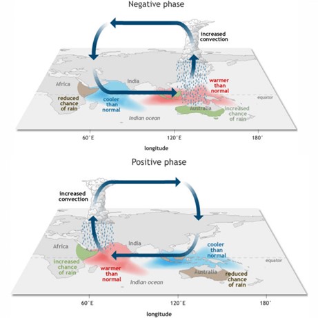
Indian Ocean Dipole (IOD) and Monsoon Anomalies
The discovery of the Indian Ocean Dipole (IOD) in 1999 explained why not all El Niño events weaken the Indian Monsoon.
Positive IOD:
- Warmer Arabian Sea (Western Indian Ocean).
- Cooler waters near Indonesia (Eastern Indian Ocean).
- Enhances Indian monsoon rainfall, even during El Niño years (e.g., 1983, 1994, 1997).
Negative IOD:
- Warmer eastern Indian Ocean near Indonesia.
- Suppressed rainfall over India, weaker monsoons.
Cyclogenesis:
- Positive IOD: More cyclones in the Arabian Sea.
- Negative IOD: More cyclones in the Bay of Bengal.
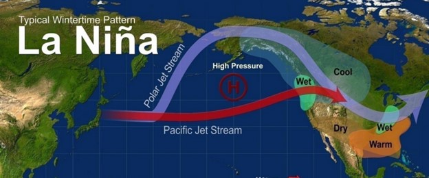
La Niña
La Niña is the opposite phase of El Niño, marked by unusually strong trade winds and abnormal cooling of the Central and Eastern Pacific waters.
Climatic Effects of La Niña:
- India: Abnormally heavy monsoons, above-normal rainfall.
- Africa: Wet winters in Southeastern Africa.
- Australia: Extremely wet conditions, frequent flooding.
- North America: Cold winters in Western Canada and Northwestern USA; winter droughts in Southern USA.
- Atlantic Ocean: Active hurricane seasons (e.g., 1998, 1999).
La Niña generally brings beneficial rains to India, but may trigger flood disasters elsewhere.
Global and National Significance
- Fisheries: El Niño devastates Peruvian and Ecuadorian fisheries by halting nutrient upwelling.
- Agriculture: ENSO drives cycles of droughts and floods worldwide.
- Indian Monsoon: Directly determines India’s food security, rural livelihoods, and inflation.
- Climate Change: ENSO frequency and intensity are being altered by global warming, complicating monsoon forecasts.