
Atmosphere and Heat Balance
Atmosphere: Structure and Composition
The Earth’s atmosphere is a complex, dynamic envelope of gases, water vapour, and dust particles surrounding the planet. It is indispensable for supporting life, regulating climate, and driving meteorological processes. About 99% of its total mass is concentrated within 32 km from the Earth’s surface, which makes the lower layers most critical for weather, climate, and biological activity.
Composition of the Atmosphere
The atmosphere comprises both permanent gases (whose proportion remains relatively stable) and variable gases (whose concentration fluctuates spatially and temporally).
Permanent Gases
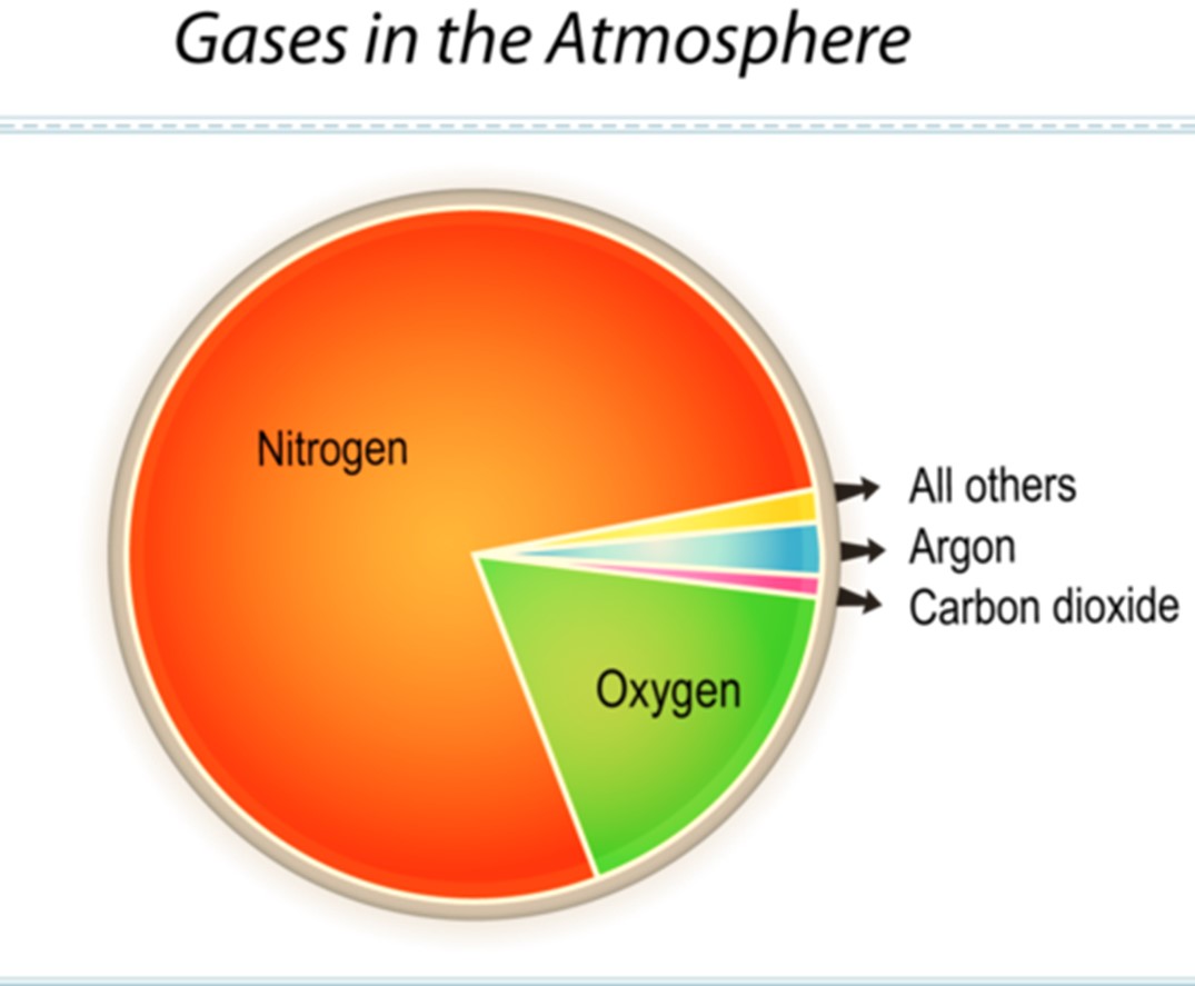
Nitrogen (N₂) – 78.084%
- Role: Acts as a diluting agent for oxygen, regulates combustion, and is essential for the nitrogen cycle and protein synthesis in living organisms.
Oxygen (O₂) – 20.946%
- Role: Crucial for respiration in animals and humans, as well as for oxidation and combustion processes.
Argon (Ar) – 0.934%
- Role: An inert noble gas with industrial utility, particularly in welding, lighting, and scientific instruments.
Variable Gases
Water Vapour (H₂O): 0–4%
- Importance: The most influential variable component in terms of climate and weather, responsible for cloud formation, precipitation, and latent heat transfer.
Distribution: Concentration decreases sharply with altitude and is lowest at the poles and deserts. [UPSC 2024]
- Importance: The most influential variable component in terms of climate and weather, responsible for cloud formation, precipitation, and latent heat transfer.
Carbon Dioxide (CO₂): ~0.04% (increasing trend)
- Role: A key greenhouse gas, transparent to incoming shortwave solar radiation but absorbing longwave terrestrial radiation, thereby regulating Earth’s heat budget. [UPSC 2024]
Ozone (O₃): Trace, concentrated in the stratosphere
- Role: Absorbs harmful ultraviolet (UV) radiation, protecting life forms. Also acts as a minor greenhouse gas.
Other Trace Gases:
- Methane (CH₄), Neon (Ne), Helium (He), Hydrogen (H₂), Krypton (Kr).
Significance: Though present in small amounts, gases like methane are powerful greenhouse gases, while helium and hydrogen dominate the upper atmospheric layers.
- Methane (CH₄), Neon (Ne), Helium (He), Hydrogen (H₂), Krypton (Kr).
Atmospheric Composition (by Volume)
Gas | Symbol | Volume (%) / ppm |
Nitrogen | N₂ | 78.084 % |
Oxygen | O₂ | 20.946 % |
Argon | Ar | 0.934 % |
Carbon Dioxide | CO₂ | 0.042 % |
Neon | Ne | 18.182 ppm |
Helium | He | 5.24 ppm |
Methane | CH₄ | 1.92 ppm |
Krypton | Kr | 1.14 ppm |
Hydrogen | H₂ | 0.55 ppm |
Ozone | O₃ | 0.07 ppm |
Note: Water vapor varies greatly with location and altitude — from nearly 0% in deserts to about 4% in tropical regions.
Structure of the Atmosphere
The atmosphere is vertically stratified into distinct layers, each with unique characteristics in terms of temperature, density, pressure, and composition.
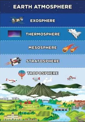
1. Troposphere (0–13/18 km)
- Importance: The zone of weather, where clouds, rainfall, storms, winds, and all biological activities occur.
- Features:
- Contains most of the atmospheric mass and almost all water vapour.
- Thickness varies: ~18 km at equator (due to strong convectional uplift) and ~8 km at poles.
- Temperature decreases with altitude at a rate of 6.5°C/km or 1°C per 165 m (lapse rate).
- Tropopause: Marks the upper limit; beyond this, no significant weather activity occurs.
2. Stratosphere (13–50 km)
- Significance: Contains the ozone layer, which shields life from UV radiation.
- Temperature Trend: Increases with altitude due to ozone absorption of solar UV rays.
- Meteorological Role: Jet streams (fast-flowing upper-air winds) influence global weather circulation.
- Aviation Use: Commercial aircraft fly here to avoid turbulence, since it is stable and cloud-free. [UPSC 2011]
3. Mesosphere (50–80 km)
- Role: Region where meteors burn up, producing “shooting stars.”
- Temperature: Decreases with altitude, making the mesopause the coldest region of the atmosphere.
- Significance: Plays a role in atmospheric circulation, though it does not contribute to the greenhouse effect.
4. Thermosphere/Ionosphere (80–400 km)
- Role: Contains large numbers of ions and free electrons, which reflect radio waves back to Earth, enabling long-distance radio communication.
- Layers: Divided into D, E, and F layers, with the F layer most important for signal transmission.
- Temperature: Can rise up to 1200°C; hence also called the thermosphere.
- Space Weather Influence: Solar storms and radiation fluctuations impact radio and satellite communication.
- Auroras: Natural light displays (Aurora Borealis & Aurora Australis) occur here due to charged solar particles interacting with Earth’s magnetic field.
5. Exosphere (400 km and beyond)
- Nature: Outermost zone where the atmosphere merges into outer space.
- Composition: Mostly hydrogen and helium, with extremely low density.
- Significance: Though meteorologically inactive, it is where artificial satellites orbit and collect climate/space data.
Atmospheric Divisions: Homosphere and Heterosphere
- Homosphere (0–80/100 km):
Composition: Well-mixed zone where gases like N₂, O₂, and Ar are uniformly distributed. - Heterosphere (Above 100 km):
Composition: Heavier gases like O₂ and N₂ settle below, while lighter gases such as He and H dominate at higher altitudes.
- Homosphere (0–80/100 km):
Solar Radiation and Insolation
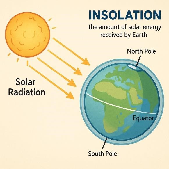
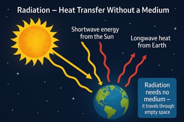
The Sun is the ultimate source of energy for the Earth, driving weather, climate, and life-supporting processes. The energy emitted by the Sun is in the form of solar radiation, produced through nuclear fusion reactions at its core. A very small fraction of this energy actually reaches the Earth’s atmosphere, but it is sufficient to maintain the planet’s heat balance and sustain ecosystems.
The incoming solar energy received on the Earth’s surface is termed insolation. It primarily arrives in the form of shortwave radiation (visible light and ultraviolet rays), while the Earth re-emits energy in the form of longwave infrared radiation.
Distribution of Solar Radiation
The amount of insolation varies both spatially (from place to place) and temporally (day, season, year). Several factors influence this variation:
1. Rotation of the Earth on its Axis
- The alternation of day and night determines the duration and intensity of insolation.
- At the poles, regions experience continuous daylight or darkness for months due to axial tilt.
2. Revolution of the Earth & Distance from the Sun
- The Earth’s orbit is elliptical.
- Perihelion (3rd January): Earth is closest to the Sun (~147 million km) → receives slightly more radiation.
- Aphelion (4th July): Earth is farthest (~152 million km) → insolation is marginally reduced.
- Thus, annual insolation is greater in January than in July, though the difference is moderated by atmospheric circulation.
3. Tilt of Earth’s Axis (66½° with orbital plane)
- Responsible for seasonal variation in insolation.
- Regions near the tropics receive more vertical rays, while higher latitudes receive oblique rays, reducing energy per unit area.
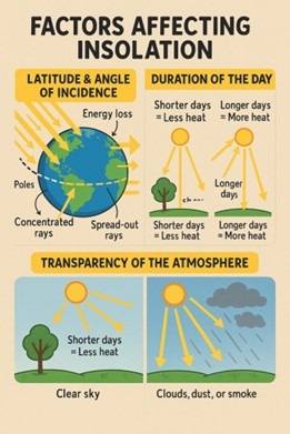
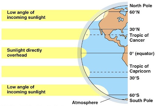
4. Angle of Solar Rays (Latitude Effect)
- Higher latitudes → slant rays travel through a thicker atmospheric column → more scattering, absorption, and reflection → less insolation.
- Lower latitudes (tropics and subtropics) → vertical rays, less atmospheric obstruction → maximum insolation.
5. Transparency of the Atmosphere
- Clear, dust-free atmosphere: Higher transmission of solar energy.
- Clouds, dust, pollutants, and aerosols: Reflect, absorb, or scatter solar energy, reducing insolation.
- Dry season: Reduced cloud cover increases insolation, especially in subtropical deserts.
6. Albedo of Earth’s Surface
- Albedo refers to the reflectivity of a surface (0 = perfect absorber, 1 = perfect reflector).
- Earth’s average albedo is ~0.3, meaning about 30% of incoming solar energy is reflected back into space, while ~70% is absorbed.
- Albedo hierarchy: Fresh Snow (0.80) > Ice > Sand > Grass > Soil > Forest > Open Ocean (0.06) > Charcoal (0.04).
- High albedo surfaces reduce net heat absorption, while darker surfaces absorb more.
7. Configuration of Land (Aspect Effect)
- Orientation of landforms influences insolation.
- In the Northern Hemisphere, south-facing slopes are warmer as they receive more sunlight, while north-facing slopes are cooler (reverse is true in the Southern Hemisphere).
Spatial Distribution of Insolation on Earth’s Surface
- Subtropical Deserts (20°–30° latitudes): Receive the maximum insolation due to vertical rays and cloudless skies.
- Equatorial Regions: Surprisingly receive lesser insolation than subtropics, as high cloud cover reflects sunlight.
- Continents vs Oceans: At the same latitude, continents heat more than oceans because of lesser cloud cover and lower specific heat capacity.
- Seasonal Contrast:
- Middle and high latitudes → receive far less radiation in winter compared to summer.
- Equatorial regions receive relatively uniform radiation year-round.
- Equator vs Poles: The Equator receives ~5 times more insolation than the polar regions.
- Continental-Oceanic Contrast: Due to higher specific heat of water, oceans heat and cool slowly, whereas land heats and cools rapidly → greater temperature contrast in summers than in winters.
Heating and Cooling of the Atmosphere
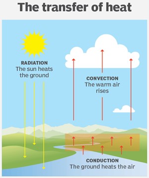
The Earth’s atmosphere is not directly heated by incoming solar radiation. Instead, most of the Sun’s shortwave energy passes through the atmosphere and is absorbed by the Earth’s surface. The surface then re-emits this energy in the form of longwave (infrared) terrestrial radiation, which in turn warms the atmosphere. This indirect mechanism explains why the lower layers of the atmosphere are warmer compared to the upper layers.
The heating and cooling of the atmosphere operate through four primary mechanisms:
1. Conduction: Heat Transfer by Contact
Conduction is the process of direct transfer of heat through molecular collisions from a warmer object to a cooler one.
In Atmosphere:
- The Earth’s land surface, after absorbing solar radiation, becomes warmer than the overlying air.
- Heat is transferred from the ground to the adjacent lower layers of the atmosphere.
- Limitation: Conduction is effective only up to a height of a few metres because air is a poor conductor of heat.
2. Convection: Vertical Transfer of Heat
Convection is the transfer of heat through vertical movement of air masses (fluids).
Mechanism:
- Heated air near the Earth’s surface expands, becomes lighter, and rises.
- As it rises, it cools and sinks, forming convection currents.
Role in Troposphere:
- Dominant in the troposphere (0–12 km).
- Responsible for cloud formation, thunderstorms, cyclones, and other weather phenomena.
Example:
- The formation of monsoon thunderstorms over the Indian subcontinent is largely a product of convective uplift of moist air.
3. Advection: Horizontal Heat Transfer
Advection refers to the horizontal transfer of heat by large-scale air masses.
Importance:
- Plays a key role in redistributing heat from equatorial regions to temperate and polar latitudes.
- Explains daily and seasonal variations in temperature across regions.
Examples:
- Sea Breeze and Land Breeze: Localised advection effect along coasts.
- Loo in North India (hot dry winds): Example of hot advection during summer.
- Monsoon Winds: Large-scale seasonal advection of moisture-laden air from the oceans to the Indian landmass.
4. Terrestrial Radiation: The Greenhouse Effect in Action
Process:
- Earth’s surface absorbs incoming shortwave solar radiation (UV + visible light).
- It re-emits this energy as longwave infrared radiation.
- Atmospheric gases such as CO₂, H₂O vapour, CH₄, O₃, and NO₂ absorb much of this infrared radiation, warming the atmosphere.
Key Point:
- The atmosphere is heated more effectively by terrestrial (longwave) radiation than by direct solar radiation.
Impact:
- Creates the natural greenhouse effect, essential for maintaining Earth’s habitable climate.
- Without this effect, the average global temperature would be about -18°C instead of the present +15°C.
The heating and cooling of the atmosphere is a complex interplay of conduction, convection, advection, and terrestrial radiation. Together, they regulate the Earth’s weather systems, climate zones, and heat balance.
Heat Budget of the Planet Earth
The Earth’s temperature remains relatively constant because the heat it receives from the Sun (insolation) is almost equal to the heat it radiates back into space (terrestrial radiation). This delicate balance ensures that the Earth as a whole neither experiences long-term heating nor cooling. The maintenance of this equilibrium is referred to as the Earth’s Heat Budget.
Concept of Heat Budget
The heat budget refers to the delicate balance between the energy received by the Earth from the Sun and the energy radiated back into space. It is this balance that regulates the climate system and maintains conditions suitable for life.
Key Components
1. Incoming Solar Radiation (Insolation):
- The Sun emits shortwave radiation, part of which is absorbed by the Earth’s surface and atmosphere.
- This energy drives weather systems, ocean currents, and the global climate.
2. Outgoing Terrestrial Radiation:
- The Earth, in turn, emits longwave infrared radiation back into space.
- Some of this radiation is absorbed and re-radiated by greenhouse gases, helping maintain the planet’s warmth.
Importance of Balance
- A surplus of heat (more energy absorbed than emitted) would lead to global warming, melting ice caps, and rising sea levels.
- A deficit of heat (more energy emitted than absorbed) would cause global cooling, potentially triggering glacial expansion.
The Earth’s heat budget acts as a natural thermostat, preventing extreme temperature fluctuations and ensuring long-term climate stability. Even small imbalances can contribute to significant climate change over geological or human timescales.
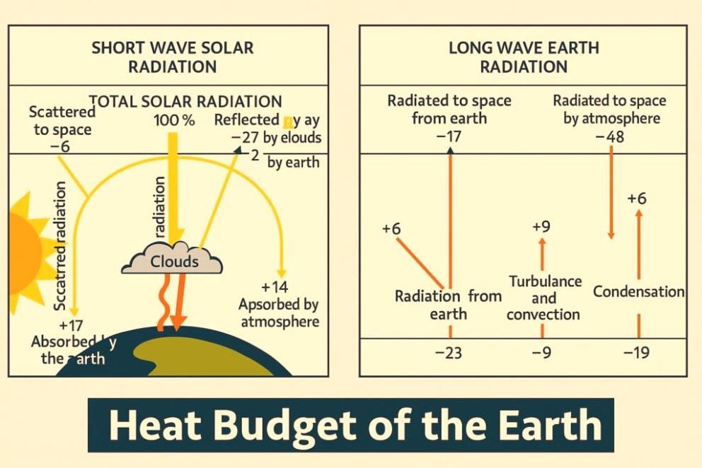
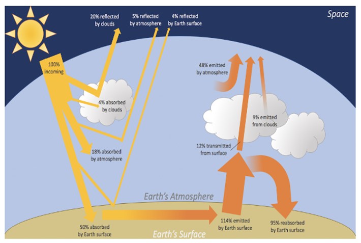
Absorption and Reflection of Solar Energy
When solar radiation enters the atmosphere, it does not reach the Earth’s surface directly. Instead, it undergoes several processes:
Reflection and Scattering:
- Around 35% of incoming solar radiation is reflected back into space before reaching the Earth’s surface.
- Of this, 27% is reflected by clouds, while 2% is reflected by snow and ice-covered areas (high albedo zones).
- The rest is reflected by dust particles and atmospheric gases.
Absorption:
- The atmosphere absorbs ~18% of solar radiation, primarily due to ozone, dust, and water vapour.
- The Earth’s surface absorbs about 47% of incoming solar energy, which is later re-radiated as terrestrial (longwave) radiation.
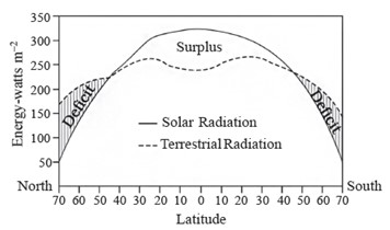
Variation in the Net Heat Budget
The Earth does not receive or lose solar energy evenly across latitudes. Instead, the distribution of incoming solar radiation (insolation) and outgoing terrestrial radiation varies significantly, creating distinct zones of surplus and deficit. This imbalance is one of the primary drivers of global atmospheric and oceanic circulation.
1. Latitudinal Distribution of Heat Balance
- The equatorial and tropical regions (0°–40° latitude) receive far more insolation than they lose through terrestrial radiation.
- This leads to a positive heat balance (surplus), which explains why these regions remain warm and humid year-round.
- Surplus energy in the tropics powers convectional rainfall, tropical cyclones, and monsoon systems.
- The polar and sub-polar regions (>40° latitude), in contrast, lose more heat through outgoing longwave radiation than they gain from insolation.
- This creates a negative heat balance (deficit), resulting in extremely cold conditions and the persistence of polar ice caps.
- The mid-latitudes (30°–40°) act as transition zones, where the incoming and outgoing energy approach equilibrium. These regions are crucial for the development of temperate cyclones.
2. Natural Redistribution of Heat
If surplus heat from the tropics and deficit in the poles were left unchecked, the equatorial regions would become unbearably hot while the poles would grow even colder. To maintain equilibrium, the Earth has evolved natural heat transfer mechanisms:
Atmospheric Circulation:
- Large-scale wind systems such as the Hadley cell, Ferrel cell, and Polar cell transport warm air poleward and cold air equatorward.
- Jet streams and planetary winds act as conveyors of this redistribution.
- Cyclones, anticyclones, and monsoons are also linked to this dynamic.
Ocean Currents:
- Warm ocean currents such as the Gulf Stream (Atlantic) and Kuroshio Current (Pacific) carry surplus heat from the equatorial regions towards higher latitudes.
- Cold currents such as the Humboldt Current (Peru Current) transport cool water equatorward, moderating the heat surplus.
- Together, these currents form a “global conveyor belt” of oceanic circulation.
This combined system of atmospheric and oceanic transport is often described as the Global Heat Engine, which prevents extreme climatic contrasts on Earth.
3. Importance of the Heat Budget
- Ensures climatic stability by balancing surplus and deficit zones.
- Explains the formation of pressure belts:
- The Equatorial Low-Pressure Belt arises from high surplus of heat.
- The Polar High-Pressure Belts are maintained by constant energy deficit.
- Governs monsoonal systems, trade winds, and temperate cyclones, directly affecting agriculture and economy.
- Acts as the foundation of the global climate system.
- Any alteration in this delicate balance (e.g., due to greenhouse gas emissions or global warming) disrupts the equilibrium, leading to climate change, melting ice caps, rising sea levels, and extreme weather events.
The unequal heating of the Earth’s surface creates a heat surplus in the tropics and a heat deficit at the poles. The resulting energy imbalance powers the circulation of winds and oceans, making the heat budget a central regulator of Earth’s climate system.
Temperature: Concepts, Factors, and Inversion
Temperature is a fundamental meteorological parameter that represents the degree of hotness or coldness of a substance, location, or atmosphere. It plays a vital role in influencing weather conditions, climate zones, agricultural productivity, and human habitation. Measured in degrees Celsius or Fahrenheit, temperature affects air density, pressure, wind circulation, and the distribution of flora and fauna across regions. In geography, the spatial distribution of temperature helps in delineating climatic zones and understanding global heat balance.
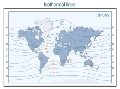
Isotherms and Their Shifting Patterns
Isotherms are imaginary lines drawn on a map that connect places having the same temperature at a given time or on average over a period. These lines provide insights into global temperature distribution and its variation across seasons. Isotherms do not follow a straight latitudinal pattern due to the differential heating of land and water bodies, the presence of ocean currents, altitude variations, and air mass movements.
In the Northern Hemisphere, where landmasses are more extensive, isotherms tend to be irregular and closely spaced. This is because land heats and cools more quickly than water, creating abrupt temperature gradients. Conversely, in the Southern Hemisphere, where oceans dominate, isotherms are smoother and more widely spaced, reflecting the ocean’s moderating influence.
The shifting of isotherms is particularly evident between seasons. During winter, when the sun is overhead in the Southern Hemisphere, isotherms bend towards the equator as cold air dominates the continents of the north. During summer, the reverse happens, with isotherms bending towards the poles. A notable instance occurs in January, where warm ocean currents like the Gulf Stream and the North Atlantic Drift raise temperatures in the North Atlantic, causing the isotherms to bend northward over the ocean and southward over the adjacent continents. This dynamic behavior highlights the role of ocean-atmosphere interactions in shaping global temperature patterns.
Temperature Anomaly: Deviations from Norms
A temperature anomaly refers to the difference between the actual temperature of a place and the expected mean temperature for its latitude. A positive anomaly indicates a region experiencing temperatures higher than the normal average, such as in the Sahara Desert, where solar radiation is intense and persistent. In contrast, a negative anomaly represents lower-than-expected temperatures, as seen in high-altitude regions like Mount Everest, where despite being in a subtropical latitude, temperatures remain extremely low due to elevation. Understanding anomalies is crucial for climate change studies, disaster preparedness, and agricultural planning.
Factors Influencing the Distribution of Temperature
Several geophysical and atmospheric factors govern the distribution of temperature on Earth:
- Latitude is the most critical determinant, as the amount of solar insolation received decreases with increasing distance from the equator. Equatorial regions receive direct sunlight, while polar zones receive oblique rays, resulting in colder climates.
- Altitude significantly affects temperature. With every 1,000-meter increase in elevation, temperature typically drops by around 6.5°C, known as the environmental lapse rate. This is because the atmosphere is primarily heated from below by the Earth’s surface, and the air becomes thinner and less capable of holding heat at higher altitudes.
- Proximity to the sea introduces the moderating effect of maritime influence. Coastal regions experience equable climates due to the high specific heat of water, which resists sudden temperature changes. In contrast, interior continental areas often suffer from extreme temperature variations.
- Ocean currents play a decisive role. Warm currents, like the Kuroshio and Brazil Current, increase coastal temperatures, while cold currents, such as the Peru (Humboldt) and Canary Current, lower them significantly.
- Air masses—large bodies of air with uniform temperature and humidity—when moved by atmospheric circulation, bring warmth or coolness depending on their origin.
- Prevailing winds influence temperature by transporting air from hot or cold regions. For instance, onshore winds in summer bring cooler sea air, while offshore winds may intensify inland heat.
- Aspect of slope refers to the direction a slope faces. In the Northern Hemisphere, south-facing slopes receive more sunlight and are therefore warmer, while north-facing slopes remain cooler.
- The diurnal (day-night) cycle, driven by Earth’s rotation, causes daily fluctuations in temperature, with highs during the day and lows at night.
- Urban Heat Island (UHI) effect results from urbanization. Cities with concrete structures, asphalt roads, reduced vegetation, and human activities retain more heat, leading to significantly higher temperatures compared to surrounding rural areas.
Temperature Inversion: Reversal of Normal Lapse Rate
Under normal conditions, temperature decreases with altitude in the troposphere. However, during a temperature inversion, this trend reverses, and a layer of warm air overlays cooler air at the surface, thereby trapping pollutants and limiting vertical mixing. This phenomenon is crucial for understanding air quality, fog formation, and microclimatic conditions in valleys and urban basins.
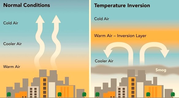
Conditions Favouring Inversion
Temperature inversion typically occurs under calm and stable atmospheric conditions, particularly during winter nights when outgoing terrestrial radiation exceeds incoming solar radiation. An absence of clouds, dry surface air, and light winds facilitate this process. In polar regions, where sunlight is minimal, inversion persists for long durations, sometimes throughout the year.
Types of Temperature Inversion
1. Surface Inversion occurs near the ground due to radiative cooling at night. It is common in higher latitudes and is often associated with fog formation when the surface air cools below its dew point. This type of inversion is usually short-lived and dissipates with morning sunlight.
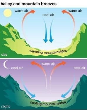
2. Valley Inversion is prominent in hilly and mountainous terrains, where cold, dense air produced on slopes descends under gravity and accumulates in valley bottoms, while warmer air remains above. This air drainage phenomenon provides protection against frost, benefiting local agriculture.
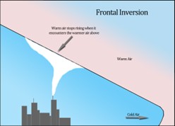
3. Frontal or Advectional Inversion occurs when a cold air mass intrudes beneath a warm air mass, lifting the latter aloft. This inversion is often unstable and breaks down as the weather system evolves, especially during frontal cyclonic activity.
Impacts and Consequences of Temperature Inversion
The implications of temperature inversion are far-reaching and affect both natural ecosystems and human health:
- Fog and Smog Formation: The trapping of pollutants like dust, smoke, and industrial emissions beneath the inversion layer causes dense fog or smog, particularly in urban-industrial regions. This can severely reduce visibility, disrupt transportation, and aggravate respiratory ailments.
- Frost Damage: In agricultural valleys, inversion can cause warm air to rise, allowing cold air to settle near the ground, leading to frost formation. Sensitive crops and orchards may suffer significant yield loss as a result.
- Atmospheric Stability: Inversions suppress vertical air movement, preventing cloud formation and rainfall. This contributes to dry conditions, drought in arid regions, and air stagnation, which deteriorates overall environmental quality.