
Water Conservation
Global Water Crisis: Over 100 Cities, Including 30 in India, at Risk of Severe Water Scarcity by 2050
A Global Challenge Looming on the Horizon
According to a recent report by the World Wide Fund for Nature (WWF), the world is heading toward an unprecedented urban water crisis. The study warns that over 100 cities across the globe—which are home to millions of people and serve as economic, political, and cultural hubs—are projected to face severe water scarcity by the year 2050.
One of the main contributors to this crisis is the rapid and unchecked pace of urbanization. The global urban population, which stood at just 17% in 2020, is expected to skyrocket to 51% by 2050, placing enormous pressure on freshwater resources, water infrastructure, and the surrounding ecosystems.
Cities at Greatest Risk
The list includes some of the world’s most significant and densely populated urban centers:
- Beijing, Jakarta, Johannesburg, Istanbul, Hong Kong, Mecca, and Rio de Janeiro are among the global cities under the highest threat.
- Over 50% of the cities identified in the report are from India and China, two of the world’s most populous nations, further intensifying the scale and complexity of the water crisis in Asia.
India: 30 Cities on the Brink of Water Stress
India, already grappling with recurring droughts, groundwater depletion, and uneven water distribution, is projected to be one of the worst-affected countries. The WWF report lists 30 Indian cities that could face acute water scarcity by 2050 if sustainable urban water management practices are not adopted urgently.
Top Indian Cities at Risk:
- Jaipur – Ranked as the most vulnerable Indian city in terms of future water scarcity.
- Indore
- Thane
- Mumbai
- Kolkata
- Delhi
These cities are facing threats due to a combination of factors such as:
- Overpopulation
- Unplanned urban development
- Overextraction of groundwater
- Pollution of freshwater bodies
- Climate change-induced variability in rainfall
The Implications of Water Scarcity
Water scarcity doesn’t only affect access to drinking water—it has far-reaching consequences for health, sanitation, agriculture, industry, and overall urban sustainability.
- Health & Hygiene: Limited access to clean water can lead to hygiene-related diseases and increased public health crises.
- Food Security: With agriculture relying heavily on water, cities facing scarcity may struggle to ensure food supply.
- Economic Impact: Water shortages can disrupt industrial processes, leading to economic slowdowns and job losses.
- Social Conflict: Scarcity may spark water conflicts among communities, cities, or even states.
Difference between Water Scarcity, Water stress and Water risk
Term | Definition | Key Indicators | Scope | Example |
Water Stress | A situation where demand for water exceeds supply during a certain period or quality is too low for use. | Water availability per capita, demand vs. supply ratio | Primarily quantitative | A city where high population density leads to high water demand, like Delhi. |
Water Scarcity | A long-term imbalance between water availability and demand, often due to physical or economic limitations. | Renewable freshwater resources per capita | Chronic/structural issue | Rajasthan faces water scarcity due to arid climate and limited resources. |
Water Risk | The potential for negative impacts related to water—physical, regulatory, or reputational. | Includes water stress, pollution, regulation, governance, etc. | Broader and multi-dimensional | A factory at risk of shutdown due to pollution regulations or poor local governance. |
Water-Scarce Regions in India
Water scarcity is a growing concern in various regions across India due to a variety of natural and anthropogenic factors. These regions experience limited freshwater availability due to arid conditions, over-exploitation, and erratic rainfall patterns. Key water-scarce regions include:
- Rajasthan – Known for its desert landscape, Rajasthan faces severe water scarcity due to low rainfall and high evaporation rates.
- Gujarat – While having a significant coastline, Gujarat faces challenges with water scarcity in its inland areas, primarily due to low groundwater recharge and over-exploitation of water resources.
- Rain-shadow areas of Western Ghats – This includes parts of Hyderabad-Karnataka and Vidarbha regions, where the terrain prevents monsoon rains from reaching the interior, resulting in dry conditions.
- Drought-prone regions – These areas frequently face the adverse impacts of drought due to low and erratic rainfall, affecting agriculture and water availability for daily use.
Water Stress Regions in India
Water stress occurs when demand exceeds available resources during certain periods or regions face significant water quality issues. The regions affected by water stress include all the water-scarce regions mentioned above, in addition to regions suffering from various environmental and human-induced factors:
- Urban and Industrial Pollution – Urbanized and industrial hubs such as the Ganga-Yamuna industrial region, along with mining hotbeds like Odisha and Jharkhand, and major metropolitan cities like Mumbai and Bengaluru, experience significant water stress due to industrial waste and urban wastewater pollution. These pollutants compromise water quality, further exacerbating water scarcity.
- Alkalinity and Salinity – The regions with over-exploited groundwater, such as Punjab and Haryana, suffer from water stress as groundwater tables deplete, leading to increased salinity and alkalinity, making water unsuitable for consumption and irrigation.
- Marine Saline Ingress – Coastal areas, especially those affected by cyclones, storm surges, or sea-level rise due to climate change, are at risk of saline water intrusion. Coastal states like Tamil Nadu and Kerala face this challenge, impacting freshwater sources and agriculture.
India’s Water Situation
Water Resources in India
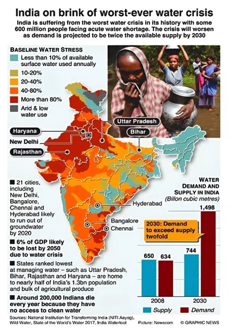
India, home to 16% of the global population, faces significant challenges in managing its water resources. Despite occupying just 2.5% of the world’s land area, the country has access to only 4% of the world’s water resources. This imbalance poses a critical concern as water scarcity becomes more pronounced across various regions.
Water Scarcity in India
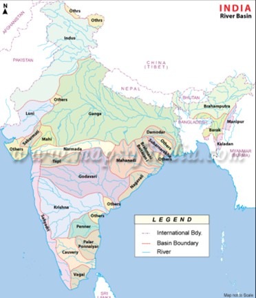
Water-scarcity conditions are particularly prevalent in the following river basins and regions:
- Indus Basin
- Krishna Basin
- Cauvery Basin
- Subarnarekha Basin
- Pennar Basin
- Mahi Basin
- Sabarmati Basin
- East-flowing Rivers
- West-flowing Rivers of Kutch and Saurashtra, including the Luni River
These basins have been experiencing challenges related to declining water resources due to over-exploitation, climate change, and increasing demands from agriculture and urbanization.
Water Resource Potential and Utilization
According to the Central Water Commission (CWC), India’s total water resource potential — including natural runoff from rivers — is estimated at 1,999 billion cubic metres (BCM). Of this, the utilisable water resources are estimated to be 1,122 BCM per year, which includes:
- 690 BCM per year from surface water
- 432 BCM per year from replenishable groundwater sources
While these resources provide a substantial foundation for meeting the nation’s needs, the rapid population growth and demand from various sectors put tremendous pressure on these already limited resources.
Per-CapitaWater Availability
India’s per capita water availability is projected to decrease significantly in the coming decades:
- 2025: 1,434 cubic metres per person per year
- 2050: 1,219 cubic metres per person per year
This drop will move India from a water-stressed condition to a water-scarce condition according to the benchmarks defined by the CWC:
- 1,700 cubic metres/person/year to 1,000 cubic metres/person/year: Water Stressed Condition
- Less than 1,000 cubic metres/person/year: Water Scarcity Condition
- 1,000 cubic metres/person/year to 500 cubic metres/person/year: Chronic Water Scarcity
- Less than 500 cubic metres/person/year: Absolute Scarcity
Minimum Water Requirement for Domestic Use:
- 50 litres per person per day is the absolute minimum water required for domestic usage.
- 100-200 litres per person per day is the ideal requirement for healthy living conditions.
Groundwater Availability in India
India is heavily reliant on groundwater for its water supply, particularly in agriculture. According to Water and Related Statistics 2019 by the CWC, the annual replenishable groundwater resources in India are estimated at 432 BCM. However, the “extractable” groundwater resources, which can be realistically used, are 393 BCM.
Currently, the annual groundwater extraction stands at 249 BCM, with the majority of the water being used by the agricultural sector, which accounts for over 80% of total groundwater usage.
Groundwater Over-Exploitation
The Central Ground Water Board (CGWB) has classified the groundwater resources of the country into three categories:
- Safe: Sufficient resources for extraction without any risk of depletion.
- Semi-Critical: Areas where groundwater extraction is approaching a critical level.
- Over-Exploited: Areas where the groundwater resources are being extracted at unsustainable rates.
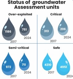
As of 2017, the distribution of India’s groundwater resources was as follows:
- 14% of the country’s groundwater assessment units are semi-critical.
- 5% are critical.
- 17% are over-exploited.
Groundwater Depletion in India and Its Impact on Agriculture
India is the second-largest producer of wheat in the world, but severe groundwater depletion threatens the future of agriculture, particularly during the winter season. As the country faces increasing challenges in managing its water resources, agricultural productivity is also at risk. Key winter crops such as wheat, barley, mustard, and peas could see a reduction in cropping intensity by up to 20% by 2025 due to diminishing groundwater levels. According to studies, 13% of villages in India that rely on groundwater for winter crop cultivation are located in critically water-depleted regions.
Flash Droughts and Declining Cropping Intensity
A recent study indicates that India could experience an increase in the frequency of flash droughts by the end of this century. Flash droughts, which are characterized by rapid and severe drying of soil, can have devastating impacts on crop yields. Even if all regions currently relying on depleted groundwater switch to canal irrigation, national cropping intensity may still decline by 7%. This demonstrates that transitioning from groundwater to surface water alone may not be sufficient to address the long-term challenges facing Indian agriculture.
Groundwater Dependency in Rural India
Approximately 85% of India’s rural water supply is dependent on groundwater, making it a critical resource for both drinking and irrigation purposes. However, the rampant extraction of groundwater for irrigation has led to a significant decline in water tables across many regions. This over-extraction poses a serious threat to the long-term sustainability of groundwater resources, further exacerbating India’s water crisis.
Impact of Groundwater Depletion on Carbon Emissions: A troubling consequence of groundwater depletion is its contribution to carbon emissions. If the groundwater level in India drops by just 1 meter, it would result in an increase of more than 1% in the country’s total carbon emissions. This underlines the urgency of addressing groundwater depletion not only for agricultural reasons but also for environmental sustainability.
Regions Most Affected by Groundwater Depletion
India’s agricultural heartlands are primarily dependent on groundwater, with the Indo-Gangetic Plain, North-western, Central, and Western parts of the country accounting for the most intensive use of groundwater for irrigation. Among these regions, Western India and the Indo-Gangetic Plain stand out, with over 90% of their irrigation needs being met through groundwater extraction.
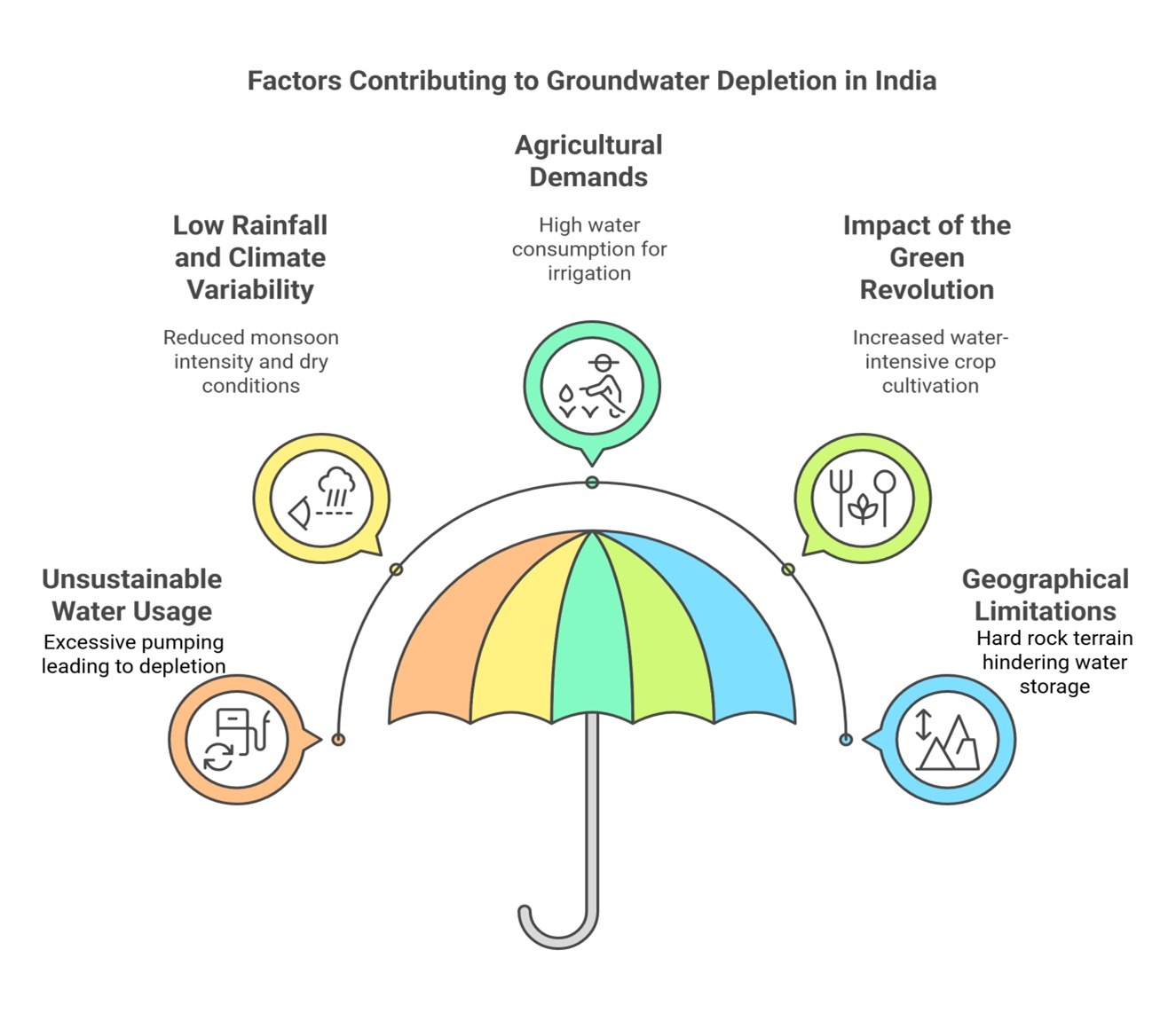
Causes of Groundwater Depletion
Several factors contribute to the ongoing depletion of groundwater resources in India:
1. Unsustainable Water Usage:
- The frequent pumping of groundwater at rates faster than it can naturally recharge has led to significant depletion in many areas.
- Usage rates exceed recharge rates, meaning the water being extracted is not being replenished at the same pace, leading to an overall decline in groundwater levels.
2. Low Rainfall and Climate Variability:
- India’s monsoon season, which is crucial for recharging groundwater reserves, has been experiencing low-intensity rainfall in many regions. Additionally, the hot and dry monsoon conditions have worsened the situation, reducing the amount of water that seeps into the ground.
3. Agricultural Demands:
- Agriculture, which requires vast amounts of water, is the largest consumer of groundwater in India. The increasing demand for water for irrigation, particularly during dry spells, exacerbates the depletion of groundwater resources.
4. Impact of the Green Revolution:
- The Green Revolution era, which began in the 1960s, brought about a significant increase in the cultivation of water-intensive crops such as rice. The introduction of high-yielding varieties and the widespread use of irrigation, particularly in regions like Punjab and Haryana, contributed to unsustainable groundwater extraction.
- Punjab and Haryana, both major wheat and rice-producing states, are particularly vulnerable to water depletion. These states, despite having predominantly light soils, saw a massive increase in rice cultivation, a crop that requires more water than other staples.
5. Geographical Limitations:
- In Central India, the presence of hard rock terrain makes it difficult to store surface water. This geological limitation means that groundwater remains the primary source of water for irrigation, further stressing the resource.
Consequences of Groundwater Depletion
The ongoing depletion of groundwater not only affects agricultural productivity but also has far-reaching consequences for India’s economy, water security, and overall environmental health. If current trends continue, India faces the risk of reduced agricultural output, increased costs for irrigation, and potential conflicts over water resources. Additionally, rural populations who rely heavily on groundwater for drinking water may face increased water scarcity, with dire implications for public health.
India’s water crisis, driven by groundwater depletion, requires urgent and sustainable solutions. Strategies to tackle the problem must include:
- Promoting Water Conservation: Implementing efficient irrigation techniques such as drip irrigation and rainwater harvesting to reduce dependency on groundwater.
- Improving Water Management: Enhancing the storage and distribution of surface water through better infrastructure, including canals and reservoirs.
- Encouraging Crop Diversification: Shifting away from water-intensive crops like rice in regions where they are not suited for cultivation.
- Enhancing Groundwater Recharge: Implementing techniques to replenish groundwater reserves, such as creating artificial recharge pits and improving the water retention capacity of the soil.
Measures by the Government
Water Conservation Initiatives in India
Water is a vital resource for both survival and economic activities, and its conservation is crucial to maintaining the sustainable development of the country. While water management is a state subject, the Central Government plays a key role in supplementing state efforts through various policies and schemes aimed at improving water conservation and management across India.
National Water Policy (2012)
The National Water Policy (2012), formulated by the Department of Water Resources, emphasizes the importance of rainwater harvesting and water conservation in India. It advocates for efficient water usage, the adoption of conservation practices, and the promotion of sustainable water management across all sectors.
In line with this, the Central Ground Water Authority (CGWA) has mandated the practice of rainwater harvesting across the country, including Union Territories (UTs), under the Environment Protection Act, 1986.
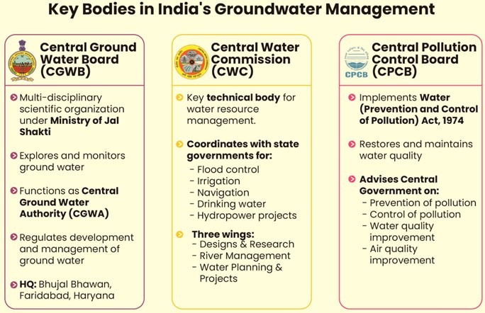
Central Ground Water Board (CGWB) Initiatives
The Central Ground Water Board (CGWB), a subordinate office under the Ministry of Jal Shakti, plays a critical role in groundwater management. In 2013, the CGWB prepared the Master Plan for Artificial Recharge to Ground Water in India, which proposes the construction of 1.11 crore rainwater harvesting and artificial recharge structures across the country. These structures are designed to harness surplus monsoon runoff and augment groundwater resources.
Model Building Bye-Laws, 2016
The Ministry of Housing and Urban Affairs (MoHUA) introduced the Model Building Bye-Laws, 2016, which recommend the implementation of rainwater harvesting systems for all buildings with a plot size of 100 square meters or more. This initiative aims to promote sustainable water management practices, especially in water-stressed regions such as Gujarat, Haryana, Karnataka, Madhya Pradesh, Maharashtra, Rajasthan, and Uttar Pradesh.
Ministry of Jal Shakti and Integrated Water Management
The Ministry of Jal Shakti was created by merging several ministries to address all water-related issues in an integrated manner. The ministry is responsible for formulating policies, guidelines, and coordinating national efforts for water conservation, management, and the sustainable development of water resources across the country.
Government Schemes for Water Conservation
Several initiatives have been launched to address the water crisis and promote conservation efforts:
1. Atal Bhujal Yojana (ATAL JAL):
- A ₹6000 crore central sector scheme funded by the World Bank that focuses on improving groundwater management in priority areas through community participation.
- The program will run from 2020-2025 and will target states like Gujarat, Haryana, Karnataka, Madhya Pradesh, Maharashtra, Rajasthan, and Uttar Pradesh.
2. Jal Shakti Abhiyan (JSA):
- A time-bound campaign aimed at water conservation in 1,592 “water-stressed” blocks in 257 districts across India.
- JSA focuses on water conservation through community participation and involves the construction of tanks, ponds, and recharge wells under the MGNREGA.
3. Jal Jeevan Mission (JJM):
- Launched in 2019, JJM aims to provide safe and adequate drinking water through household tap connections to all rural households by 2024.
- The mission also includes source sustainability measures such as greywater management, rainwater harvesting, and water conservation practices.
4. Micro Irrigation Fund (NABARD):
- Aimed at promoting efficient irrigation techniques like drip irrigation and sprinkler systems to reduce groundwater dependence.
5. National Perspective Plan (NPP):
- A scheme focused on transferring water from surplus regions to deficit areas to achieve equitable distribution across the country.
6. Pradhan Mantri Krishi Sinchayee Yojana – Watershed Development Component (PMKSY-WDC):
- A program aimed at improving water efficiency in agriculture and promoting watershed development to ensure sustainable water availability.
Central Ground Water Authority (CGWA)
The Central Ground Water Authority (CGWA), established under the Environment Protection Act, 1986, plays a critical role in regulating the development and management of groundwater resources across the country. The CGWA has been given the following powers:
- Regulate and control groundwater extraction: CGWA is responsible for overseeing the withdrawal of groundwater, particularly in regions that are over-exploited or critical.
- Monitor groundwater levels: The CGWA ensures that groundwater extraction does not exceed sustainable limits by imposing penalties for violations.
National Green Tribunal (NGT) vs. CGWA
The National Green Tribunal (NGT) has recently struck down the CGWA’s 2020 guidelines, stating that they were not in line with legal provisions. The NGT emphasized that Environmental Impact Assessments (EIA) should form the basis for granting permissions for groundwater extraction, particularly for commercial entities. Additionally, the NGT stressed that permissions must specify the time frame and quantity of groundwater withdrawal rather than granting indefinite permissions.
Central Water Commission (CWC)
The Central Water Commission (CWC), established in 1945, is a technical organization under the Ministry of Jal Shakti responsible for the consultation, coordination, and implementation of water conservation projects. The CWC works closely with states to address issues related to flood management, irrigation, drinking water supply, and hydroelectric generation.
National Aquifer Mapping and Management Programme (NAMMP)
The National Aquifer Mapping and Management Programme (NAMMP) is a central sector initiative aimed at mapping the quantity, quality, and sustainability of groundwater resources. The program helps in understanding groundwater issues and creating management plans for the sustainable use of aquifers.
Challenges and Limitations in Water Conservation Programs
Despite the government’s significant efforts, several challenges persist:
- Lack of Scientific Planning: Programs like the Jal Shakti Abhiyan have been criticized for not incorporating scientific planning, such as hydrological unit-based water management or basin-wise rainfall analysis. This has resulted in disjointed water conservation efforts.
- Insufficient Coordination: Many water conservation schemes suffer from poor coordination between various departments, leading to ineffective implementation.
- Unsustainable Water-Intensive Crops: The government has yet to address the issue of water-intensive crops such as paddy, sugarcane, and banana, which continue to dominate agriculture in water-stressed regions.
- Short-Term Solutions: Some water management interventions, like soil bunds built under MGNREGA, collapse within a short time, indicating a lack of long-term planning and engineering expertise.
Water Conservation and Supply Initiatives in Urban India
In addition to the various rural water supply schemes, India is also making significant strides to improve water accessibility in urban areas. Recognizing the increasing demand for water in cities, the government has launched several programs aimed at providing universal water supply coverage to urban households while ensuring sustainable water management practices. These initiatives are in line with the objectives set by Sustainable Development Goal 6 (SDG 6), which aims to ensure clean water and sanitation for all.
Jal Jeevan Mission (Urban)
The Jal Jeevan Mission (Urban) was launched under the Ministry of Housing and Urban Affairs with the goal of ensuring universal access to safe drinking water for all urban households through functional tap water connections. This initiative is designed to complement the Jal Jeevan Mission (Rural), which focuses on providing water to rural households.
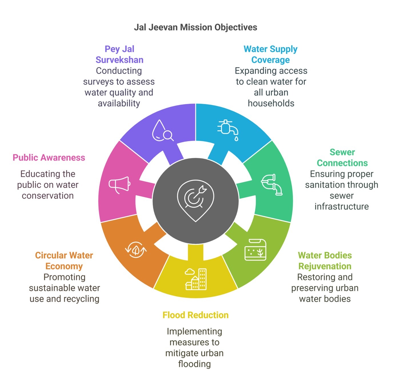
Objectives of the Jal Jeevan Mission (Urban)
The mission is aimed at bridging the significant water supply gap in urban areas and includes the following objectives:
Coverage of Water Supply:
- It aims to cover an estimated gap of 2.68 crore urban household tap connections, ensuring that more households have access to safe drinking water through taps.
Sewer Connections:
- The mission also aims to provide 2.64 crore sewer connections in 500 AMRUT cities, thereby enhancing sanitation infrastructure across urban areas.
Water Bodies Rejuvenation:
- The mission focuses on the rejuvenation of water bodies to augment the sustainable freshwater supply and create green spaces within cities. This approach ensures both environmental sustainability and enhanced urban living conditions.
Flood Reduction and Urban Aquifer Management:
- By implementing Urban Aquifer Management plans, the mission aims to reduce the occurrence of floods while enhancing the amenity value of cities. This involves improving groundwater recharge and optimizing water usage.
Circular Water Economy:
- Promoting the circular economy of water is another key objective of the mission. This involves focusing on the reuse and recycling of treated sewage, rejuvenating water bodies, and implementing water conservation strategies.
- Promoting the circular economy of water is another key objective of the mission. This involves focusing on the reuse and recycling of treated sewage, rejuvenating water bodies, and implementing water conservation strategies.
Public Awareness Campaign:
- The mission will also include an extensive Information, Education & Communication (IEC) campaign to raise awareness about water conservation and sustainable water use practices among urban residents.
Pey Jal Survekshan:
- The Pey Jal Survekshan will be conducted in cities to assess:
- Equitable distribution of water to ensure all urban areas have access to water.
- The reuse of wastewater, focusing on optimizing water resources and reducing wastage.
- The Pey Jal Survekshan will be conducted in cities to assess:
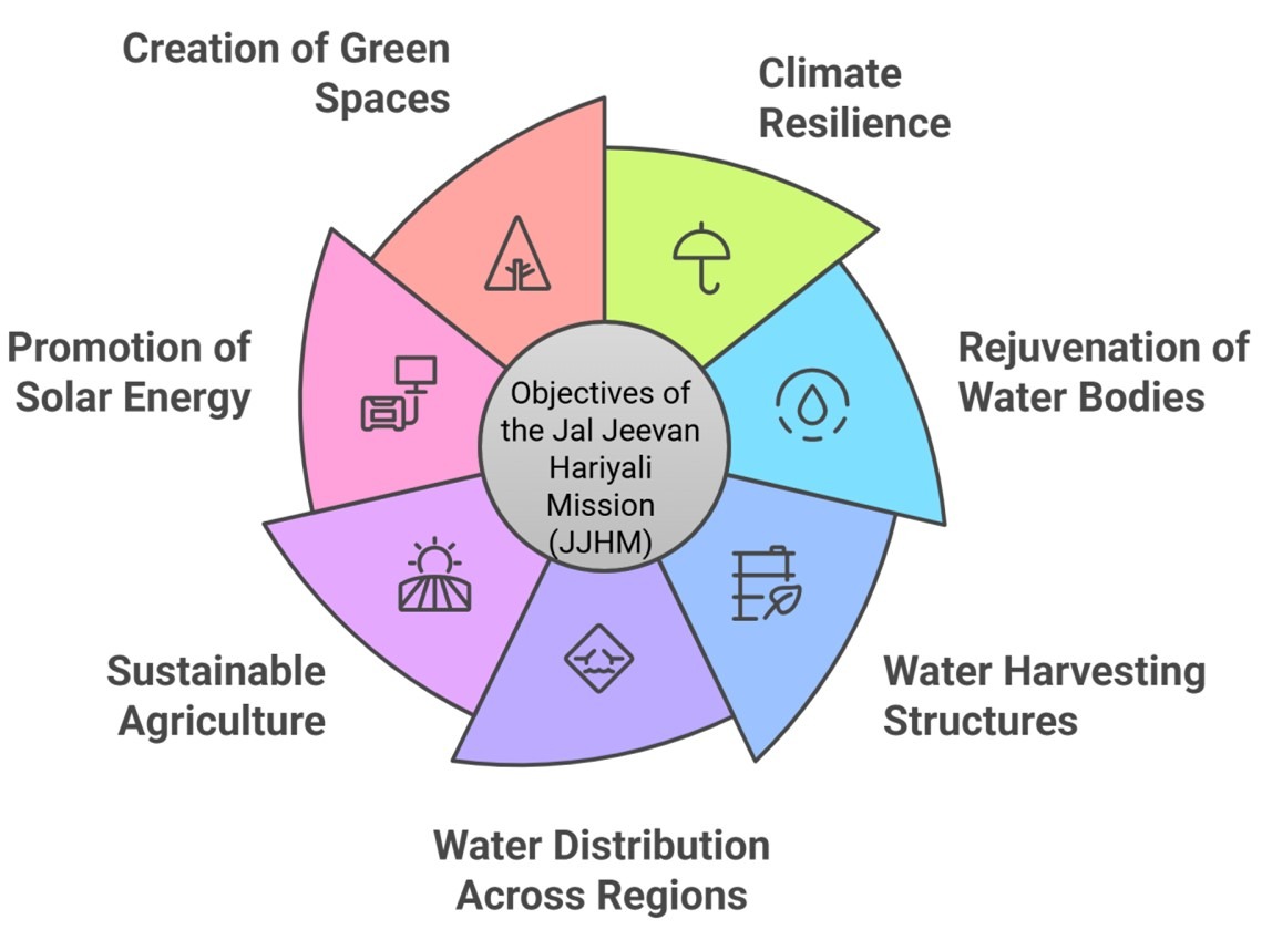
Jal Jeevan Hariyali Mission (JJHM)
In addition to urban water supply initiatives, the Jal Jeevan Hariyali Mission (JJHM), launched by the Government of Bihar, aims to address water conservation and sustainable water management in the state. It is an autonomous body under the Rural Development Department and focuses on ensuring climate sustenance, the conservation of water bodies, and groundwater rejuvenation.
Objectives of the Jal Jeevan Hariyali Mission (JJHM)
The key goals of the JJHM include:
Climate Resilience:
- The mission seeks to build climate-resilient agricultural systems by ensuring the availability of adequate water resources throughout the year.
Rejuvenation of Water Bodies:
- It emphasizes the rejuvenation of public conventional water storage structures like ponds, lakes, and reservoirs, helping to restore natural water sources.
Water Harvesting Structures:
- The mission also supports the construction of check dams, water harvesting structures, and rainwater harvesting systems in buildings to improve the collection and storage of rainwater.
Water Distribution Across Regions:
- By creating new water sources and facilitating the delivery of water from surplus river areas to water-deficit regions, the mission ensures that all areas have access to water resources.
Sustainable Agriculture:
- The mission promotes alternative cropping methods, including drip irrigation and organic farming, which are more water-efficient and sustainable for agricultural communities.
Promotion of Solar Energy:
- Solar energy is encouraged for agricultural and water-related activities, promoting energy conservation and reducing the carbon footprint associated with water pumping.
Creation of Green Spaces:
- To ensure environmental balance, the mission includes initiatives for tree plantation, the creation of nurseries, and the development of green spaces across rural and urban areas.
Har Ghar Gangajal Scheme
Another important initiative under the Jal Jeevan Hariyali Mission is the Har Ghar Gangajal scheme, which aims to provide access to Ganga water in areas with severe water scarcity, such as Rajgir, Gaya, and Bodhgaya in Bihar. These regions are known for their rocky terrain and low groundwater levels, and excessive groundwater extraction has caused a significant drop in the water table.
Key Features of the Har Ghar Gangajal Scheme
Lift, Store, and Supply:
- The scheme operates on a “lift-store-tame-treat-supply” model. Excess Ganga water is harvested during the monsoon season, treated, stored, and then piped to the water-deficient regions.
Water Deficit Areas:
- This scheme specifically targets regions like Rajgir, Gaya, and Bodhgaya, which face acute water shortages due to their geographical conditions and overuse of groundwater.
Sustainable Water Supply:
- The initiative aims to ensure a sustainable supply of freshwater in these areas by tapping into the abundant water resources of the Ganga River.
National Hydrology Project (NHP)
The National Hydrology Project (NHP) is a comprehensive pan-India initiative, funded by the World Bank as a Central Sector Scheme, and is being implemented with a 100% grant to the States. Launched in the year 2016-17, this ambitious project is set to run for a duration of 8 years, with an expected completion by 2023-24. The primary aim of the NHP is to revolutionize water resources management in India by providing a cutting-edge, real-time system for data acquisition, storage, collation, and management of water resources across the country.
Through this project, India seeks to build an advanced infrastructure for hydrological data, ensuring that real-time data is accessible to stakeholders at various levels, from State and District to even village levels. This initiative is designed to mitigate the recurring challenges posed by floods and droughts, particularly in vulnerable regions, by providing up-to-date information for accurate forecasting and timely alerts, which have historically been difficult to issue due to the lack of real-time ground data.
Key Objectives of the National Hydrology Project
1. Improvement of Hydrology and Groundwater Data Reliability:
One of the primary goals of the NHP is to improve the accuracy and reliability of hydrological and groundwater data across the entire country. This data will serve as the foundation for better water resource planning and management. Accurate, up-to-date data is essential for addressing challenges such as water scarcity, flood management, and sustainable development.
2. Establishment of a Comprehensive Hydrological Database:
The project will help establish an effective and integrated hydrological database, which will serve as a critical resource for water resource managers, policymakers, and scientists. The database will be centralized and will house all relevant data, including water levels, discharge rates, rainfall data, and groundwater measurements, among other crucial hydrological parameters.
3. Design Aids for Water Resource Planning and Management:
The NHP will also involve the development of advanced design aids to support more effective water resources planning and management. These tools will help authorities make data-driven decisions on water allocation, flood control, and irrigation strategies, leading to more efficient and sustainable water use across the nation.
4. Building Resilience Against Flooding and Droughts:
With climate change resulting in increased uncertainty in weather patterns, floods and droughts have become recurring issues. The NHP aims to enhance India’s resilience to these extreme weather events by providing real-time data and forecasting models that can better predict water-related disasters and enable timely interventions.
Key Features of the National Hydrology Project
1. Real-Time Data Acquisition and Management:
One of the core features of the NHP is its real-time data acquisition and management system. The project will establish a nationwide network of hydrological observation stations that will continuously collect data on various water parameters. This real-time information will be made available to stakeholders at all levels, improving the ability to respond to emerging situations promptly.
2. Access to Data at Local Levels:
The NHP will decentralize data accessibility, ensuring that it can be accessed by users at the State, District, and village levels. This will allow local authorities and communities to make informed decisions about water usage, conservation efforts, and disaster management.
3. Advanced Forecasting and Early Warning Systems:
By providing access to real-time data, the NHP will improve India’s ability to forecast floods and droughts. This will help in issuing early warnings, minimizing the damage caused by such disasters. Early detection will allow for the evacuation of people from flood-prone areas, and for planning water conservation measures ahead of drought periods.
4. Integrated Approach to Water Resources:
The NHP is designed to integrate data from multiple sources, such as groundwater and surface water systems. This integration allows for a holistic approach to water management, considering all aspects of the water cycle and ensuring that water resources are utilized in the most efficient and sustainable way.
5. Improved Disaster Management:
The project also aims to improve disaster management capabilities by providing detailed and accurate data on water-related hazards. With more precise forecasting, the NHP will help authorities plan better for potential floods, droughts, and other water-related disasters. This data can help with infrastructure planning, such as dam construction, flood defenses, and water storage systems, ensuring that the country is better prepared for climate extremes.
Why is the National Hydrology Project Important?
1. Enhanced Water Resource Management:
- One of the biggest challenges India faces today is the inefficient management of its water resources. By collecting and centralizing hydrological data, the NHP will help streamline the planning and management of water resources, ensuring that water is distributed efficiently and effectively to meet the demands of agriculture, industry, and urban areas.
2. Climate Resilience:
- As the effects of climate change continue to intensify, India needs to adapt its water management strategies. The NHP will provide essential tools for climate resilience, allowing the country to better prepare for fluctuations in water availability and manage the risks posed by extreme weather events.
3. Sustainable Water Use:
- With rising demands for water across multiple sectors, ensuring the sustainable use of water is essential. By using real-time data, the NHP will help ensure that water usage is optimized and that resources are not depleted in an unsustainable manner. This will contribute to long-term water security for India.
4. Improving Forecasting and Disaster Management:
- The real-time data provided by the NHP will improve forecasting capabilities, enabling more accurate predictions of floods, droughts, and other water-related disasters. With better data, India can reduce the human and economic costs associated with such disasters.
5. Empowering Local Communities:
- By making hydrological data accessible at the village, district, and state levels, the NHP empowers local communities to take control of their own water resources. With accurate data at their disposal, they can implement more effective water management practices, including water conservation, irrigation planning, and disaster preparedness.
Recommended Conservation Measures
Clean Water Sanctuaries
India faces a critical challenge when it comes to ensuring access to clean water. Currently, more than 70% of India’s surface water (rivers and lakes) and groundwater is polluted, making safe drinking water a significant concern for the population. As a result, many Indians will soon need Reverse Osmosis (RO) systems in their homes, which will only add to the existing pressure on the water purification infrastructure. However, amidst this crisis, there are still some sources of pure, unpolluted water that remain largely untapped. These include the floodplains of rivers and the subterranean natural mineral water found beneath forested areas. Both sources hold promise for the future, offering sustainable and non-invasive solutions to the water scarcity problem.
1. Floodplains and Organic Forests:
The floodplains, which have historically been crucial for groundwater replenishment, offer a potential solution for sourcing bulk water. These areas can be preserved by planting organic food forests or fruit forests, which require minimal water usage. By safeguarding these floodplains, we can secure access to unpolluted water without disturbing the delicate wetland ecology. Importantly, creating artificial lakes in floodplains, a recent suggestion, could disrupt the existing ecosystem, as it would require extensive sand digging and lead to evaporation losses. Therefore, protecting and enhancing these natural floodplains remains an essential strategy.
2. Subterranean Natural Mineral Water:
Beneath the forests of India lies some of the highest quality natural mineral water in the world. This water originates from unpolluted rainwater that percolates through the humus or leaf cover on the forest floor, gaining vital nutrients before moving through underlying rocks, where it picks up minerals. The result is water that is both pure and nutrient-rich, ideal for drinking. The Western and Eastern Ghats, as well as other forested regions, are home to such high-quality forest aquifers. These natural water reserves can provide a sustainable source of drinking water without relying on polluted surface water or groundwater.
Sponge City Concept
The Sponge City concept is an innovative urban design that aims to address the growing challenges of water scarcity and urban flooding. A Sponge City is designed to conserve, store, recharge, and sustainably use water. Unlike traditional cities with impermeable surfaces (concrete and asphalt) that prevent water from filtering into the ground, a Sponge City mimics the properties of a sponge, absorbing and naturally filtering rainwater.
In a Sponge City, the absorbed rainwater is allowed to percolate through the soil, enriching urban aquifers, and enabling water extraction through urban wells for use in the city’s water supply system. This concept aims to make urban areas more water-efficient, flood-resistant, and environmentally sustainable.
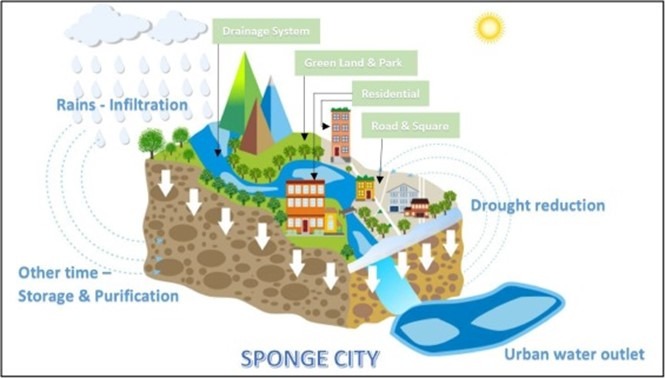
What Does a Sponge City Need in Practice?
1. Green Spaces:
- A Sponge City requires a significant amount of open, permeable spaces that allow water to seep into the ground. These spaces include parks, gardens, wetlands, ponds, and canals that interconnect neighborhoods and provide a network for water to flow through.
2. Green Roofs:
- In addition to open spaces, green roofs are vital in a Sponge City. These roofs are designed to capture and retain rainwater, which is then naturally filtered through the soil before being recycled or allowed to percolate back into the ground.
Benefits of a Sponge City
1. Replenished Groundwater:
- By allowing water to naturally percolate into the ground, Sponge Cities help recharge urban aquifers, increasing access to groundwater and improving water availability.
2. Cleaner Groundwater:
- The increased volume of naturally filtered rainwater also results in cleaner groundwater. As rainwater is absorbed through the soil, it undergoes a natural filtration process, removing impurities and improving water quality.
3. Reduction in Flood Risk:
- The permeable surfaces in a Sponge City provide greater capacity for water to be absorbed, reducing the risk of urban flooding. This is especially crucial during heavy rainfall or storm events, as it prevents water from pooling and flooding the streets.
4. Lower Burden on Infrastructure:
- With more water being absorbed naturally, there is a reduced need for extensive drainage systems, water treatment plants, and artificial channels. This reduces the maintenance costs and energy consumption associated with managing urban water systems.
5. Enhanced Biodiversity:
- A Sponge City fosters greener, healthier environments by creating spaces for urban gardens, wetlands, and green rooftops. These areas can become habitats for wildlife, improving urban biodiversity and creating more enjoyable living spaces for residents.
Measures Required for Water Conservation
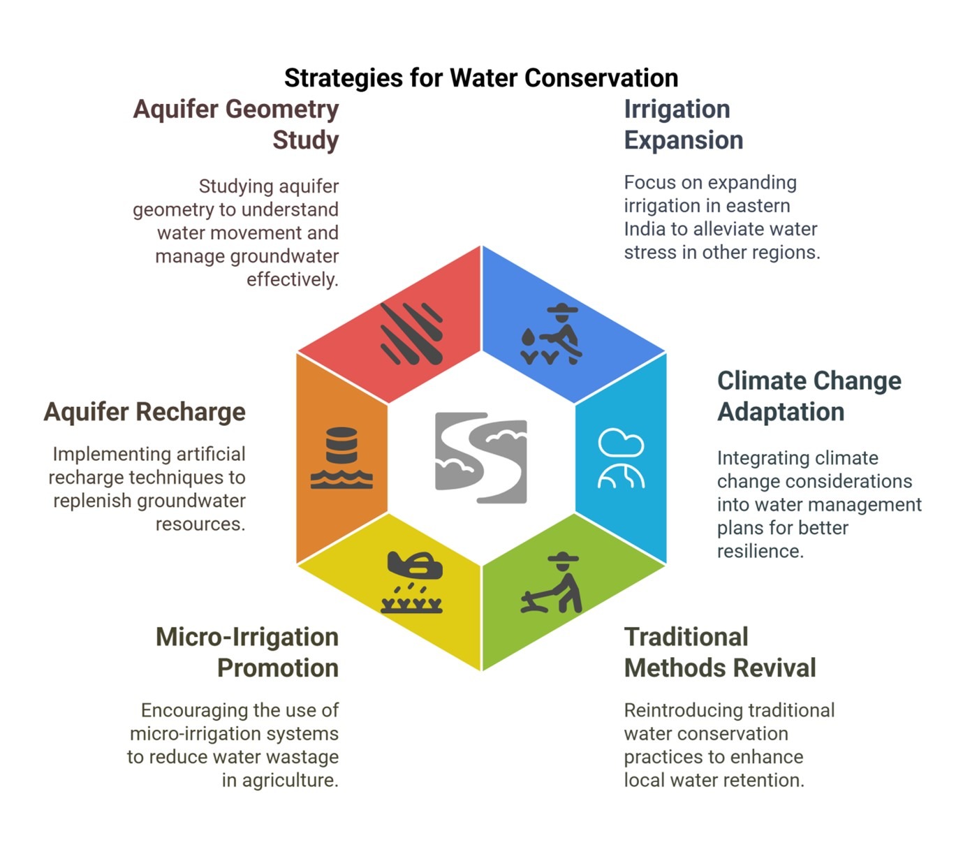
To tackle India’s water crisis, several key measures are required to ensure the sustainable use of water resources across the country.
1. Expanding Irrigation in Eastern India:
- Policies in eastern India must focus on expanding irrigation to increase agricultural productivity and reduce the pressure on water resources in north-western states.
2. Incorporating Climate Change into Water Resource Management:
- Water resource management plans need to be more dynamic and responsive to the effects of climate change, allowing for better predictions and adaptation strategies that account for altered rainfall patterns and water availability.
3. Reviving Traditional Conservation Methods:
- Traditional water conservation practices such as farm ponds, check dams, gully plugging, dug wells, and borewells should be revived to promote local water retention. The use of artificial glaciers in Ladakh and the Tamaswada Pattern nallahs treatment in Maharashtra have already shown promising results in enhancing water conservation.
4. Encouraging Micro-Irrigation:
- The government has initiated several programs like the DRIP program, Krishi Sinchai Yojana, and More Drop Per Crop to encourage farmers to adopt micro-irrigation systems such as drip irrigation and micro-sprinklers. These methods significantly reduce water wastage in agriculture and promote efficient water use.
5. Artificial Recharge of Aquifers:
- Artificial recharge of tube wells, water reuse, afforestation, and scientific agricultural practices should be integrated into water management plans to ensure sustainable water resources.
6. Studying Aquifer Geometry:
- It is crucial to study the geometry of aquifers to understand how water moves through underground layers. Special attention should be given to the saline-fresh interfaces near coastal areas, and to the effects of glacier melting on aquifer recharge in regions like the Ganga basin. Understanding these dynamics will be key to maintaining and improving groundwater supplies, especially in arid and semi-arid regions.
Droughts
What is Drought?
A drought is traditionally defined by the Indian Meteorological Department (IMD) as a consequence of a long-term reduction in precipitation. This lack of rainfall is often coupled with high temperatures, strong winds, and low relative humidity, which exacerbate drought conditions.
Drought conditions are declared based on the following key factors:
- Rainfall Deviation: A deficiency in rainfall when compared to the long-term average.
- Dry Spells: Extended periods without rainfall that lead to water shortages.
According to the Manual for Drought Management 2016, the IMD defines a drought year as one in which:
- Rainfall deficiency exceeds 10% of the Long Period Average (LPA).
- More than 20% of the area is affected by drought conditions (moderate or severe).
- When 40% or more of the area is affected, it is classified as an All India Severe Drought Year.
Droughts in India are categorized into three primary types:
- Meteorological Drought: Lack of rainfall over a region.
- Hydrological Drought: Decreased water availability in rivers, reservoirs, and groundwater systems.
- Agricultural Drought: Impact of water scarcity on crop production.
International Efforts for Drought Management
Droughts are a global challenge, and several international organizations are working to mitigate their impacts:
- United Nations Development Programme (UNDP): Launched the Integrated Drylands Development Programme (IDDP) to strengthen resilience in dryland regions by addressing poverty and unsustainable land management.
- United Nations Office for Disaster Risk Reduction (UNISDR): Developed a Drought Risk Reduction Framework, providing a comprehensive approach for both higher-level and local actions to reduce the impacts of drought.
- World Meteorological Organization (WMO) & Global Water Partnership (GWP): Launched the Integrated Drought Management Programme (IDMP) to tackle droughts with a focus on three key pillars:
- Monitoring and Early Warning Systems: To track and analyze drought indicators such as precipitation and temperature.
- Vulnerability and Impact Assessment: To assess the social, economic, and environmental factors affecting drought-impacted communities.
- Mitigation and Response: Measures include both structural (like dams and engineering projects) and non-structural (such as policies and public awareness) solutions.
Flash Droughts and Droughts in India: Understanding the Phenomenon and Its Management
What are Flash Droughts?
Flash droughts are extreme weather events that intensify rapidly, posing serious risks to agriculture, ecosystems, and water availability. Unlike conventional droughts, which can take months or years to develop, flash droughts can occur in a matter of weeks to months, often due to intense weather anomalies. These rapid developments make it difficult to anticipate and mitigate their impacts effectively. Flash droughts are often localized but can also spread over wide regions. For instance, in 1979, India experienced a severe flash drought that impacted about 40% of the country. Several factors contribute to flash droughts, including atmospheric anomalies and anthropogenic greenhouse gas (GHG) emissions, which alter weather patterns and intensify drought conditions.
Drought Management in India
In India, the management of drought is not governed by a single, legally accepted definition. Some states have their own criteria for declaring drought-affected regions. The National Disaster Management Authority (NDMA), however, is responsible for long-term drought mitigation and preparedness. The authority works closely with state governments to assess and respond to drought conditions, with the state government having the final authority to declare a drought.
India has issued two important documents for drought management:
- Manual for Drought Management, 2009: Published by the Ministry of Agriculture.
- Guidelines for Management of Drought, 2010: Published by the National Disaster Management Authority (NDMA).
However, these guidelines are non-binding, and the responsibility for implementing drought management strategies falls largely on the state level.
Way Forward for Drought Management in India
Given the severity and unpredictability of drought events, India needs to adopt efficient drought management practices and ensure better preparedness for future droughts. Here are some key steps that can be taken:
1. Efficient Drought Monitoring and Early Warning Systems:
- Developing and implementing real-time monitoring and early warning systems for droughts is essential to reduce the vulnerability of affected regions.
2. Drought Vulnerability and Impact Assessment:
- Regular assessments must be conducted to evaluate the social, economic, and environmental impact of drought conditions, allowing for more accurate and timely responses.
3. Framework for Assessment of Benefits and Costs (BACI):
- Implementing a framework for assessing the benefits of action and the cost of inaction is crucial for shifting from crisis management to a risk management approach in drought policy.
4. Incorporating National Drought Management Policy Guidelines:
- The WMO and GWP have codified National Drought Management Policy Guidelines that provide a template for countries to develop comprehensive drought management policies and preparedness plans.
Preventive and Mitigation Measures
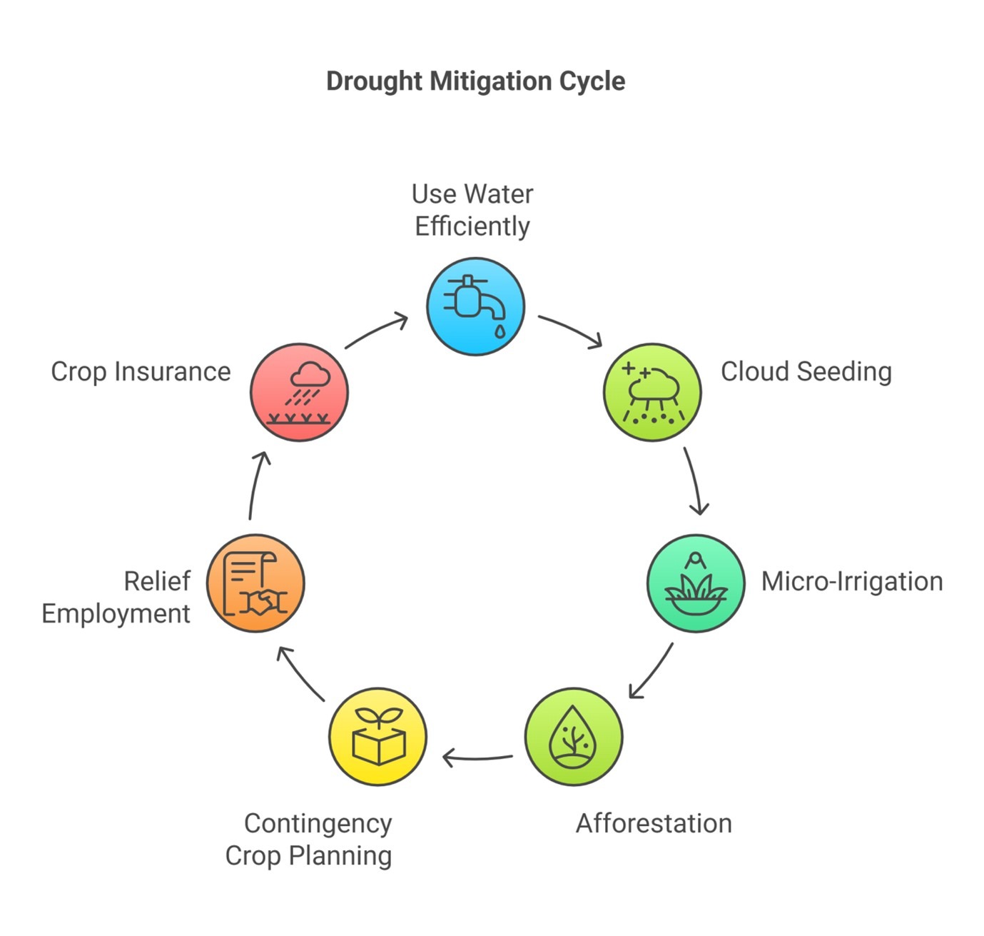
To reduce the frequency and intensity of droughts, several preventive and mitigation measures can be adopted:
1. Judicious Use of Water Resources:
- Surface and groundwater must be used efficiently to ensure sustainable water availability.
2. Cloud Seeding:
- The cloud seeding technique could be explored in drought-prone regions to increase rainfall artificially.
3. Micro-Irrigation Systems:
- Adoption of modern micro-irrigation methods such as drip and sprinkler irrigation can reduce water wastage in agriculture.
4. Afforestation and Water Conservation:
- Afforestation efforts and the revival of traditional water conservation techniques, such as rainwater harvesting and water storage structures, should be prioritized.
5. Contingency Crop Planning:
- Ensuring that farmers have access to drought-resistant crops and contingency crop plans is crucial for reducing the impact of droughts on agriculture.
6. Relief Employment Programs:
- Drought relief programs like MGNREGA (Mahatma Gandhi National Rural Employment Guarantee Act) should be expanded to provide employment during drought periods, helping communities recover.
7. Crop Insurance:
- Providing comprehensive crop insurance schemes such as the PM Fasal Bima Yojna can provide financial security to farmers in drought-prone areas.
UNCCD’s Drought Atlas
At the UNCCD COP16 in Riyadh, the UN Convention to Combat Desertification (UNCCD) and the European Commission’s Joint Research Centre launched the World Drought Atlas – a comprehensive global publication on drought risks and solutions.
Key Findings of the UNCCD’s Drought Atlas?
- Systemic Nature of Drought Risks:Drought is a systemic risk affecting multiple sectors globally. It projects that by 2050, 75% of the world’s population (nearly 3 in 4 people) will be affected by drought conditions if current trends continue.
- In 2022 and 2023 alone, 84 billionpeople (nearly 1 in 4 globally) were affected by drought, with about 85% in low- and middle-income countries.
- Economic Consequences:Droughts can severely impact agriculture, energy production, and trade. UNCCD asserts that the economic costs of the damages done due to droughts is underestimated by4 times amounting to USD 307 billion per year.
- Drought Vulnerability in India:India is particularly vulnerable to drought due to its diverse climatic conditions and reliance on monsoon rains for agriculture.
- The Atlas underscores that approximately60% of India’s agricultural land is rain-fed, making it susceptible to fluctuations in rainfall patterns.
- The 2016 drought in Southern Indiawas due to exceptionally low rainfall during both summer and winter monsoons.
- Rapid urbanizationhas caused water mismanagement in cities like Chennai, leading to a severe crisis despite ample rainfall.
- The UNCCD report blames human activitiesand occasional lack of rain for drought and resource degradation.
- Systemic Nature of Drought Risks:Drought is a systemic risk affecting multiple sectors globally. It projects that by 2050, 75% of the world’s population (nearly 3 in 4 people) will be affected by drought conditions if current trends continue.
Key Recommendations of the World Drought Atlas?
Governance:
- Countries should develop and implement comprehensive national drought plans to enhance preparedness and resilience against drought events.
- Strengthening international collaboration is essential for sharing knowledge, resources, and best practices to effectively manage drought risks across borders.
- Developing financial mechanisms, such as microinsurance for smallholder farmers, can provide safety nets for vulnerable populations affected by drought.
Land Use Management:
- Sustainable agriculture practices, such as land restoration via reforestation, soil conservation, crop diversification and agroforestry, are essential for building resilience against drought.
- These measures reduce runoff and increase stormwater retention, improving soil quality, providing shade for livestock and reducing evapotranspiration, which strengthens vegetation’s resilience to drought
Management of Water Supply and Use:
- Investment in Infrastructure:Increased investment in infrastructure for water supply and management, such as wastewater reuse and groundwater recharge systems, is necessary to enhance water security during droughts
NDMA guidelines for Drought Management-
- NDMA guidelines include developing vulnerability profiles for regions, communities, population groups, and others to compile critical informationwhich when integrated into the planning process can enhance the outcome of the process of identifying and prioritizing specific areas.
- Specific Drought Management cells should be created at the state level under SDMA. These DMCs will be responsible for the preparation of vulnerability maps for their respective states. Arid and semi-arid areas that are most vulnerable should be given priority where drought is a recurring feature occurring with varying magnitudes.
- Specific guidelines for use of Information and Communication Technology (ICT) and role of the National Informatics Center (NIC) for online interaction and availability of real-time drought-related informationthat will help in the assessment and early warning.
- Assessment of damage expected will include agricultural production, depletion of water resources, livestock population, land degradation, and deforestation as well as human health.
Drought is a slow-onset natural disaster characterized by prolonged periods of inadequate rainfall, leading to significant water shortages. As part of the Earth’s natural climate variability, it can strike any region and poses serious threats to human health, agriculture, economic stability, and energy resources. Recognizing and addressing its far-reaching impacts is essential for building resilient communities and sustainable development.